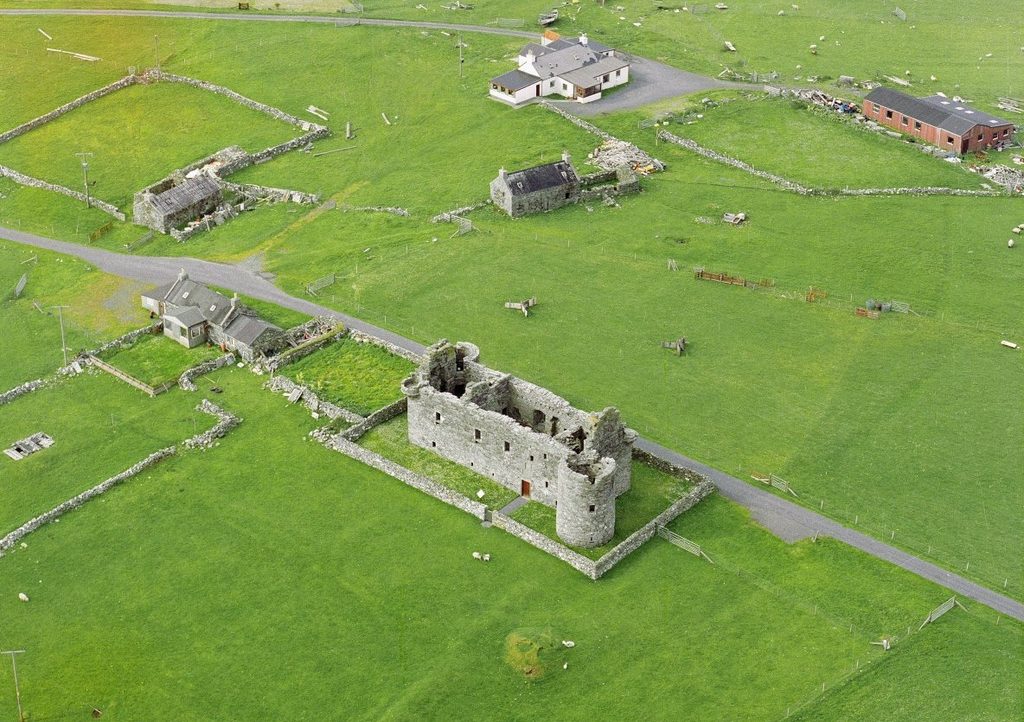
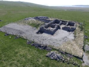
Post-medieval and modern archaeological research highlights a structural shift across Shetland from a rural society shaped by Norse cultural systems to a frontier integrated into global trading and industrial networks. This transformation is manifested in elite Scottish architecture, which was introduced to Shetland during the late 16th and early 17th centuries to enforce legal and economic hegemony over the islands. Fortified coastal sites, such as Muness Castle (c AD 1598) and Scalloway Castle (c AD 1600), represent the sudden dominance of the new Scottish elite during this period (Fawcett 1994).
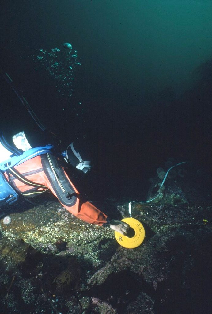
The excavation of the 16th century Kebister Tithe Barn revealed the physical infrastructure needed to systematically extract local agricultural and fishing wealth under this new system (Owen and Lowe 1999). At this time, Shetland’s strategic location in the North Atlantic transformed it into a key mercantile station. Marine surveys and material evidence from early modern Dutch and Scandinavian shipwrecks, such as the Kennemerland (c AD 1664) and Wrangles Palais (c AD 1687), have provided rich assemblages of foreign currency, trade goods, and continental wares. The evidence from these sites highlights the density of global shipping routes (Dobbs and Price 1991, Bound and Sharpe 1995, 1996).
On land, this trade network is visible at sites like Gunnister Voe, where excavations have unearthed böds (small seasonal trading booths) used by German merchants from the Hanseatic League. These merchants established shore bases to trade European goods, imported pottery, clothing, and spirits for dried Shetland cod caught during the intensive ‘haaf’ (deep-sea) fishing seasons (Gardiner and Mehler 2010).
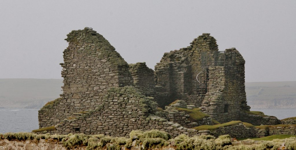
Multi-period coastal settlements illustrate the economic evolution. For example, at Jarlshof, a 17th century laird’s house was built directly on top of older prehistoric and Norse settlements (Hamilton 1956, Strachan 2008). Rural domestic life adapted alongside these shifting networks. 18th and 19th century crofts exhibit complex phases of architectural modification, relying on a lifestyle which combined small-scale farming and commercial fishing. This era also left a distinct landscape of small-scale industrial production, including hundreds of horizontal stone watermills and soapstone (steatite) quarries used for crafting hearths and domestic utensils (Forster and Turner 2009, Turner et al 2009).
One of the most prominent coastal sites from this period is Fort Charlotte, an artillery fort with angled bastions overlooking Bressay Sound. Originally constructed in 1652 during the Anglo-Dutch War, Fort Charlotte was burned down in 1673. A century later, the site was extensively rebuilt and updated from 1781 onward to counter American privateers and French naval threats. The significance of the fort extended well into the modern period, where it served as a Royal Naval Reserve base, town jail, courthouse, coastguard station and drill hall (Ewart 2007).
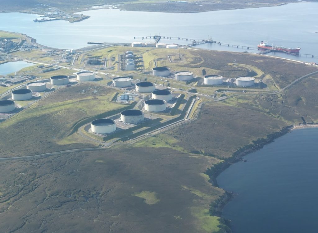
Shetland’s 20th century archaeological research has focused largely on the expansion of modern militarisation. Geopolitical conflicts left an extensive concrete footprint across the islands, notably the World War II coastal artillery batteries at Calback Ness, as well as anti-aircraft installations and early radar stations (Redfern 1998). This strategic military frontier transitioned into an industrial landscape in the late 20th century. The 1970s construction of the Sullom Voe Oil Terminal fundamentally reshaped the topography, economy, and archaeological record of north Mainland (Gifford 1992, 510).
You can download the datasheet for more information on the post-medieval & modern sites and c14 dates from Shetland.
Post-medieval & modern Research Questions
SIRFA SH99: What do shipwrecks off Shetland’s coast tell us about changes in maritime activity throughout the post-medieval era?
More information on this question
Local framework numbering:
SIRFA SH99
More information:
Where are the shipwrecks and what do the remains of these vessels suggest about the nature and purpose of post-medieval maritime activities associated with Shetland? What is known about post-medieval shipwrecking within Shetland’s waters? How frequently were ships or boats wrecked in Shetland’s waters and how did this change over time? Furthermore, what does the distribution of shipwrecks around Shetland tell us? It is recommended that extensive underwater survey work and desk-based research is carried out during the initial stages of this research.
SIRFA SH100: What did the religious lives of Shetland communities look like post-1500?
More information on this question
Local framework numbering:
SIRFA SH100
More information:
Religion is a fundamentally important aspect of daily life for many throughout history, and so the exploration of the religious lives of Shetlanders is crucial to understanding post-medieval Shetland. What does the physical archaeology of post-medieval religion and belief systems across Shetland look like? Is it possible to find evidence of the impact of religion on daily life?
SIRFA SH101: How did the Clearances manifest in Shetland?
More information on this question
Local framework numbering:
SIRFA SH101
More information:
The Clearances are perhaps one of the most significant events in Scotland’s history from the past three hundred years. Yet, relatively little archaeological research has focused on understanding this period in Shetland. How did the clearances manifest in Shetland? What physical evidence of Shetland’s clearances can be identified? How does the archaeological evidence of Shetland’s Clearance enhance our understanding of this period from other sources? Developer-led survey and excavation work on the Weisdale Clearance landscape has already begun to shed light on this topic (ORCA 2024) as well as highlighting the potential for this type of work to further advancing of this important topic. Other landscape focused projects – research or developer led – have the potential to further contribute. In a developer-funded context, the research significance of clearance sites needs emphasising. Alongside this, the need for accurate and thorough recording of structures and material culture and the importance of dating and other post-excavation work on material of this period.
SIRFA SH102: What did Shetland’s pre-clearance landscape look like?
More information on this question
Local framework numbering:
SIRFA SH102
More information:
What do we know about the pre-Clearance settlements of Shetland? Where were they and what did they look like? Pre-Clearance structures/settlements are under-researched, as well as frequently overlooked and undervalued. Can we date these settlements? When were they first established? What can be learnt from these sites about pre-Clearance Shetland life? And how does an understanding of pre-clearance landscapes aid understanding of the impacts of Clearance? In a developer-funded context, the research significance of pre-clearance or potentially pre-clearance sites and materials needs emphasising. Alongside this, the need for accurate and thorough recording of structures and material culture and the importance of dating and other post-excavation work on material of this period.
SIRFA SH103: How did Shetland’s religious landscapes change throughout the post-medieval period?
More information on this question
Local framework numbering:
SIRFA SH103
More information:
Part of the church’s post-medieval power lay in the structure and ownership of land. How was the post-medieval religious landscape structured? Where were the parish churches founded and how did this change over time? How did church land ownership expand or diminish through time from 1500 onwards? Does the structure of the landscape and the extent of church land link to the expansion and reduction of the church’s influence in Shetland? Targeted surveys of the post-medieval landscape in conjunction with map regression work and use of historical sources are likely to help expand understanding of this topic. In a developer-funded context, the significance of post-medieval religious sites needs to be emphasised. Accurate and through recording of post-medieval sites alongside post-excavation and dating work will be important.
SIRFA SH104: How did Shetland’s ‘urban’ settlements develop during the post-medieval period?
More information on this question
Local framework numbering:
SIRFA SH104
More information:
Although predominantly rural, Shetland has several towns and settlements that emerge throughout the post-medieval period that can be classed as ‘urban’. How did these urban settlements grow and develop? When did ‘urban’ settlements first appear in Shetland? What was the origin of Shetland’s large modern settlements? In particular, what is the earliest archaeological evidence for Lerwick? What can the urban archaeology of Shetland tell us about Shetland’s history and economic growth? Whilst Shetland’s urban development is relatively well documented, there is surprisingly little archaeological evidence and more work is clearly required. Encouraging people to report finds might produce new evidence. Shetland was not included in the Historic Environment Scotland’s Burgh Survey Project, however this approach could be adopted for both Lerwick and Scalloway, and perhaps Baltasound. A lack of data for this period and topic is a key barrier. It is likely that a series of research projects will be required to enhance knowledge and understanding. Collating and assessing existing archaeological information, use of existing archives and museums collections, map-regression work and use of historical documents are all likely to be important approaches. Developer funded research is likely to play an important role in enhancing data and information for this period and topic. In a developer-funded context, the significance of post-medieval urban remains needs to be emphasised, with accurate and thorough recording of structures and material culture and post-excavation work prioritised.
SIRFA SH105: How did the concept of ‘monumentality’ feature in Shetland’s post-medieval landscape?
More information on this question
Local framework numbering:
SIRFA SH105
More information:
The concept of ‘monumentality’ is familiar within archaeological narratives of Shetland’s prehistory. Adopting a similar thinking, what was ‘monumental’ about Shetland’s medieval and post-medieval landscapes? Parish churches were likely some of the most substantial and visually dominating buildings in these landscapes. Were they considered ‘monumental’ by Shetland’s medieval and post-medieval communities? What about secular features of the landscape? For example, might Shetland’s harbours and ships, substantial expressions of post-medieval engineering, be considered monumental?
SIRFA SH106: Where were Shetland’s post-medieval boat noosts and boat houses?
More information on this question
Local framework numbering:
SIRFA SH106
More information:
For the post-medieval period, as with earlier periods, there are substantial knowledge gaps around how people in the past accessed, navigated and interacted with the sea. For the post-medieval period there is a sense that these knowledge gaps are less crucial; historic documents trace the establishment of Shetland’s key ports and harbours and provide some information on navigation technology and key marine industries and activities. Yet, little is still known about local or community scale interactions with the sea throughout the post-medieval period. Where are Shetland’s post-medieval boat noosts and boat houses? What of natural harbours and their use throughout the post-medieval period? What does the geographic distribution of boat noosts and boathouses suggest about marine-based subsistence practices and the wider economy throughout the post-medieval period? Furthermore, what does the evidence suggest about the need for marine transport and wider connections during Shetland’s post-medieval period? Crucially, how do we identify and date boat noosts? Can we observe changes through the post-medieval period with regard to the way in which the sea was accessed, navigated and used across Shetland? What characterises post-medieval boat noosts; how big are they, what kind or size of vessels did they likely accommodate? Were there differences in either distribution or character across the archipelago, suggestive of more localised practices? The recent Caain da Noosts Project coordinate by Moder Dy is an excellent example of a community engagement project with the aim of information gathering on this topic. In addition to this, targeted surveys are recommended as key first steps in addressing these wider questions. A fundamental aspect of this research will centre on dating these features – OSL dating has been shown to be useful in some contexts OSL (Sandison et al), but there is far more work required in terms of dating, the variety of forms and potentially function. Also, where it exists, oral history could be a valuable resource to mine. Exploring new methods is also encouraged. In a developer-funded context, the importance of boat-noosts, natural harbours and boat houses for enhancing our understanding of past marine practices needs to be emphasised. Accurate recording of these features and, where appropriate, dating and post-excavation work. We also need a better understanding of the post-medieval coastline.
SIRFA SH107: How should Shetland’s contemporary industrial landscapes be recorded from an archaeological perspective?
More information on this question
Local framework numbering:
SIRFA SH107
More information:
Many people do not recognise Shetland’s contemporary industrial landscapes as archaeological contexts (yet). Nevertheless, these industrial landscapes have been key in shaping contemporary life in Shetland, are integral parts of the island’s rich heritage, and, arguably, will form key evidence for future archaeologists who seek to understand the islands’ past. There is currently research underway on the linen industry, which includes some interest in associated archaeological remains. Shetland’s knitwear industry has been relatively researched, but little interest in the mechanised industrial developments which were key features of the 20th century. Weaving and the exploitation of mineral resources in Shetland are two glaring gaps in current research. What archaeological methodologies should be used to record these contemporary industrial places? How can we know what information or data will be of most value, importance, use, or interest in the future?
SIRFA SH108: Is there evidence of pre-modern shieling use in Shetland?
More information on this question
Local framework numbering:
SIRFA SH108
More information:
Shielings in Shetland are typically associated with the modern era, specifically regarded as post-18th century phenomena; is this accurate or were sheilings across Shetland built and in use prior to this? What is the earliest evidence of shieling use in Shetland? If sheilings were built and used only post-18th century, why is this so different from the evidence elsewhere in Scotland? Does this suggest different land use and agricultural practices across Shetland in comparison with other regions? Were shielings in use prior to the mid 20th century in Shetland? How did Sheiling culture differ between Shetland and other places such as the Faroes or the Outer Hebrides? It is likely that interdisciplinary approaches will be valuable here, specifically the use of historical documents and place name evidence. Excavation of sheiling sites alongside programmes of scientific dating is recommended. Within a developer-funded context the importance of sheilings and sheiling landscapes for our understanding of the development of the post-medieval landscapes needs to be emphasised.
SIRFA SH109: How was access to coastal and marine resources structured throughout the post-medieval period?
More information on this question
Local framework numbering:
SIRFA SH109
More information:
It is commonly accepted that Shetland’s post-medieval landscape was structured around township divisions that included access to both agricultural and pastoral land. However, access to the coast and sea as part of post-medieval township structures is less well understood. Where were the key post-medieval shore-based fishing sites and natural harbours? What about access and rights to coastal resources and offshore fishing grounds? Were these organised and structured by township or were there different management structures at play for marine and coastal resources? Did this change over time and if so how and why? Hanseatic trade and fishing for the lairds is reasonably well documented and understood – however, the evidence for this is not always obvious. This ties into the lairds, the truk system and crofters rights (or lack of them). There will be a significant body of documentary evidence around this that could be used to complement archaeological research.
SIRFA SH110: What impact did Christianity and landownership by the church have on the development of Shetland’s modern landscape?
More information on this question
Local framework numbering:
SIRFA SH110
More information:
Christianity and land ownership by the church has had a profound and lasting impact on the social structure of modern Scottish society as well as on the character and structure of the modern landscape. Can more in-depth analysis of Shetland’s ecclesiastical landscapes enhance our understanding of Shetland’s modern landscape? How has the location of churches, chapels and other religious sites impacted the development of modern settlements, the construction of roads and other infrastructure? How has Christian land ownership impacted settlement and population distribution and density across the islands?
SIRFA SH111: What was the impact of oil on Shetland?
More information on this question
Local framework numbering:
SIRFA SH111
More information:
Oil led to significant changes to Shetland’s society, infrastructure, transport and economy. Currently, this is being researched in terms of daily life and in terms of the oil industry itself. But there were also major changes in building construction (domestic, civic and religious), in the abandonment of croft houses for new housing, changes to transport links etc, all of which has created modern archaeological remains which could easily be lost. Studying the physical impacts of the oil industry, especially while documentary evidence and oral history are still available, is not only valuable in its own right but has the potential to be extrapolated backwards and shed light on other periods of dramatic changes in Shetland’s past and how that becomes visible in the landscape. In addition, there are the buildings which were put up as part of the oil industry’s construction phase and subsequently demolished – what are the impacts of these changes? Survey is a major component of research here. Developer led work needs to acknowledge and incorporate the value of recent remains in terms of excavation and recording.
SIRFA SH112: What was the impact of modern road building in Shetland?
More information on this question
Local framework numbering:
SIRFA SH112
More information:
There were only a couple of very short lengths of road in Shetland prior to the creation of the Meal Roads in the 1850s. What impact did new road developments have? Where were the earlier tracks and what evidence do we have on them? How were they constructed? This is an area which is beginning to be researched via developer led excavation (CFA) and a survey project is planned for 2025 (Archaeology Shetland). Developer led recording of tracks and accompanying research will also be important.
If you have answered a research question, or have an update to add about a specific site or period, you can use our inline comments to flag the change and keep the frameworks up to date.
Register for an account, or login now to add updates and comments to our existing frameworks.