
Gerald F Bigelow
Scotland has extensive coastal sand environments, particularly in the northeast, the Outer Hebrides, Orkney and Shetland. Many settlement sites and human burials have been discovered in these specialised environments through marine and aeolian erosion, resulting in an ever-growing number of excavations (for example MacLaren 1974, Dockrill et al 1994, Gilbertson et al 1999, Sharples 2005, Griffiths and Ashmore 2011, Gal 2019, Sharples 2020). These sites are frequently rich in evidence because later burial in sand after their abandonment protected building remains, finds and bioarchaeological evidence from human disturbance, and mechanical and biological decay processes. However, archaeological sites in coastal sand are also particularly threatened by increasing erosion associated with rising sea level and other climate change impacts.
The archaeology of Scottish coastal sand sites demonstrates that these areas attracted human settlement at various times, but they were then abandoned at other periods when windblown sand from nearby beaches covered dwellings and arable and grazing lands. Since the 1970s (Lamb 1977) these episodes of landscape destabilization have been attributed to shore effects of increasing storm activity associated with periods of cooling climate, a model of causation based heavily on historically recorded ‘sand catastrophes’ on Scottish coasts (Lamb 1991). The almost complete destruction of the Broo Township, in southernmost Shetland, by the mid-18th century BC is a frequently cited example of such proposed interactions of climate, weather, geology and changes in settlement patterns (see Dawson 2009).
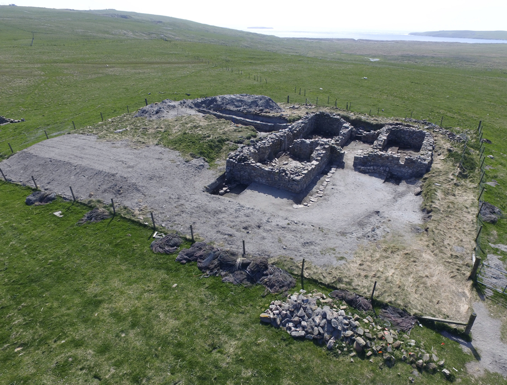
Twenty years ago, the Shetland Islands Climate and Settlement Project was formed to test this model through researching the causes and human responses to the destruction of the Broo Township community of four farms by drifting sand (Bigelow et al., 2005). This relatively recent event was chosen as a case study because it was recorded in part in historical records, its archaeological evidence was predicted to include artifacts that could be dated closely (eg coins, early modern trade ceramics and pipes), it caused huge environmental and human impacts and it occurred during an extreme phase of Little Ice Age climatic cooling (Ljungqvist et al 2012).
A combined programme of archival, archaeological and environmental research in the former area of Broo has continued with the support of the US National Science Foundation Division of Polar Programs and Bates College. The programme has been supported by the Shetland Amenity Trust, Shetland Museum and Archives, South Mainland Community History Group, Dunrossness Primary School, and many other local organisations and individuals in Sumburgh and Dunrossness. In 2013, the project was honoured to receive an Environmental Award from the Shetland Amenity Trust in recognition of contributions made to environmental and heritage education.
Interim Findings
It has been impossible to assemble a comprehensive picture of the sand movements and settlement abandonments at Broo because much of its area was ultimately covered by up to 2m of sand. However, archaeological surveys located the Broo Site Complex, one of the four township farms, where eight seasons of excavations have taken place (Bigelow et al 2005, Bigelow 2012, Bigelow et al 2007, Bigelow et al 2014, Bigelow 2024). In addition, multiple types of environmental surveys and analyses have been performed (Kinnaird et al 2014, Bampton et al 2017, Kelley et al 2018).
Key findings
Chronology of the Catastrophe
At this point archival, archaeological and Optically Stimulated Luminescence (OSL) dating evidence all converge in suggesting that the last and most destructive movements of sand at Broo began sometime around 1670-80, and most of the township was destroyed by the early 1720s (Bigelow 2024, Kinnaird et al 2013). Earlier, ephemeral sand blows affected the Broo Site Complex in the mid-1300s and mid-1500s but do not appear to have created significant accumulations of sand (Kinnaird et al 2014). The earliest formation of dunes at Quendale Beach appears to have occurred in the Neolithic Period, in common with other investigated sand sites in southernmost Shetland (Gillmore and Melton 2011).
Progression of the Sand Invasion
The Broo Site Complex is located 1.8 km from Quendale Beach and it must have been affected late and possibly last by the inland expansion of the sand. The site was clearly abandoned in two phases between the later 1690s and the mid-1720s. Given the location of the Cross Kirk, a medieval and post-medieval chapel only 300 metres from the current shoreline, it is likely that other Broo farms were closer to the shoreline and were impacted by the sand earlier.
Adaptations to a Growing Crisis
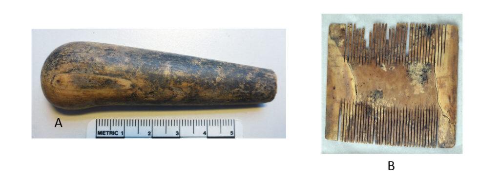
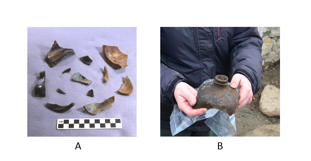
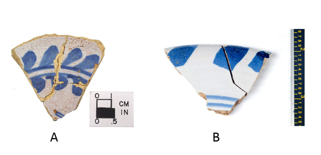
We do not yet know when the Broo Site Complex was established and its buildings were first constructed, but so far, the earliest identified finds recovered are from the mid-17th century. It is thus possible that it was a tenant farm that was relocated from a more shoreward area as an adaptation to the advance of the sand. What is abundantly clear from the site’s artefacts and building history is that the farm became the home of the township’s Sinclair proprietors sometime before 1690. Artefacts from the late occupation include various prestige ceramics, implements made from elephant ivory and large quantities of window glass and fragments of bottles for imported alcoholic beverages. A hall-type room with an unusually wide fireplace and carefully crafted window openings was added in this late phase, doubling the size of the original farm’s main dwelling. Around or shortly after this time several small stone walls were also built to limit or delay sand accumulation within the farmhouse yard and may have been a more prosaic and practical response to the crisis.
What Caused the Catastrophe?
Although the first phase of the project recovered much information about the earliest and the latest sand movements at Broo, we need to expand the geological survey area and the methods used to recover types of information that could indicate the role of storms in triggering the destabilization of the vegetated, sandy, shoreline strip, opening it to deflation and transport inland. Other promoters of geomorphological instability could have been changes in human land use or the introduction of rabbits (Bampton et al 2017, Kelley et al 2018).
Both variables could have increased the vulnerability of coastal sand grasslands to deflation, and recent research on a global scale by coastal geomorphologists has underlined the critical role played by vegetation in sustaining the stability of fixed dune systems under different climatic regimes (Jackson et al 2019, Jackson and Short 2020). Past episodes of climatic cooling may yet be shown to be an important driver of sand movements on Scottish shores but working more as a synergistic contributing agent to economic changes in farm practice and weather limits on plant growth, not as a monolithic stimulus to storm activity. More work on the rich evidence of the Broo catastrophe should aid in assessing alternative models for these environmental transformations with such broad human consequences. The relevance of these findinds to modern issues in coastal management is clear.
References
Bampton, M, Kelley, A, Kelley, J, Jones, M and Bigelow, G F 2017 ‘Little Ice Age catastrophic storms and the destruction of a Shetland Island community’, Journal of Archaeological Science 87, 17-29.
Bigelow, G F 2012 ‘Broo; survey, paleoenvironmental research and excavation’, Discovery and Excavation in Scotland, New Series 12, 170-171.
Bigelow, G F 2024 ‘Research into the destruction of the 17th century Broo Township, Shetland Islands, through burial in aeolian sand: an update’, in Smith, M and Tait, I (eds) History Maker: Essays in Honour of Brian Smith, Lerwick: The Shetland Times.
Bigelow, G F, Ferrante, S M, Hall, S T, Kimball, L M, Proctor, R E and Remington, S L 2005 ‘Researching catastrophic environmental changes on northern coastlines: a geoarchaeological case study from the Shetland Islands’, Arctic Anthropology 42, 88-102.
Bigelow, G F, Friel, R M and Outram, Z M 2014 ‘Shetland Islands, Dunrossness. Broo, survey, paleoenvironmental research and excavation’, Discovery and Excavation in Scotland, New Series, 14, 172-174.
Bigelow, G F, Jones, M and Retelle, M 2007 ‘The Little Ice Age, blowing sand and a lost township’, The New Shetlander 240, 6-12.
Dawson, A 2009 So foul and fair a day: a history of Scotland’s weather and climate, Edinburgh: Birlinn Ltd.
Dockrill, S J, Bond, J M, Milles, A, Simpson, I and Ambers, J 1994 ‘Tofts Ness, Sanday, Orkney. An integrated study of a buried Orcadian landscape’, In Luff, R and Rowly-Conwy, P (eds) Whither Environmental Archaeology? Oxford: Oxbow.
Gal, E L 2019 The archaeological potential of windblown sand and its impacts on prehistoric settlements and landscapes in the Orkney Islands, Scotland, PhD thesis, University of St Andrews.
Gilbertson, D D, Schwenninger, J-L, Kemp, R A and Rhodes, E J 1999 ‘Sand-drift and soil formation along an exposed North Atlantic coastline: 14,000 years of diverse geomorphological climatic and human impacts’, Journal of Archaeological Science 26, 439-469.
Gillmore, G K and Melton, N D 2011 ‘Early Neolithic sands at West Voe, Shetland Islands: implications for human settlement’, in Wilson, L (ed) Human interactions with the geosphere: the geoarchaeological perspective, London: The Geological Society.
Griffiths, D and Ashmore, P 2011 ‘Aeolian archaeology: the archaeology of sand landscapes in Scotland’, Scottish Archaeological Internet Reports 48. https://doi.org/10.9750/issn.2056-7421.2011.48
Jackson, D W T, Costas, S and Guisado-Pintado, E 2019 ‘Large-scale transgressive coastal dune behaviour in Europe during the Little Ice Age’, Global and planetary change 175, 82-91.
Jackson, D W T and Short, A (eds) 2020 Sandy beach morphodynamics: form and process, Amsterdam: Elsevier.
Kelley, J T, Kelley, A R, Sorrell, L, Bigelow, G F and Bampton, M 2018 ‘Evidence for a former transgressive dune field: Shetland Islands, United Kingdom’, Journal of Coastal Research, 34, 1289-1302.
Kinnaird, T C, Sanderson, D C, Winnaird, T C and Bigelow, G F 2014 ‘Luminescence dating of wind-blown sands from archaeological sites in Shetland: early modern farmstead, Broo Peninsula, Norse settlement, Sandwick South, Unst’, East Kilbride: Scottish Universities Environmental Research Centre.
Lamb, H H 1977 Climate: past, present and future. Vol. II, London: Methuen.
Lamb, H H 1991 Historic storms of the North Sea, British Isles and Northwest Europe, New York: Cambridge University Press.
Ljungqvist, F C, Krusic, P J, Brattström, G and Sundqvist, H S 2012 ‘Northern hemisphere temperature patterns in the last 12 centuries’, Climate of the Past 8, 227-249.
Maclaren, A 1974 ‘A Norse house on Drimore Machair, South Uist’, Glasgow Archaeological Journal 3, 9-18.
Sharples, N (ed) 2005 A Norse farmstead in the Outer Hebrides: excavation at Mound 3, Bornais, South Uist, Oxford: Oxbow Books.
Sharples, N 2020 A Norse settlement in the Outer Hebrides: excavation on Mounds 2 and 2a, Bornais, South Uist, Oxford: Oxbow Books.