
Jacqui Mulville
The sites of Hamar and Underhoull in Unst, the most northerly inhabited Scottish island, were investigated as part of the Viking Unst Project (Turner et al 2013). Unst has many structures which are assumed to be Viking or Norse. In contrast to the emerging pattern of Viking settlement on pre-existing multiperiod settlements with good agricultural land, such as Old Scatness, these sites seem to be short-lived, with no earlier settlement (Dockrill et al 2010, Bond et al 2013, Bond and Dockrill 2023). The aim of the investigation was to elucidate this settlement pattern, date the sites and test the theory that they were single-period.
There are two longhouses at Hamar. House 1 is aligned downslope, on a natural platform, while House 2 lies along the contour of the hill. House 2 was thought to be late post medieval in date. However, a test excavation produced late Norse rectangular bowl fragments, schist whetstones and a quantity of carbonised barley from the end of occupation which gave dates between the 15th to the 17th centuries AD.
IMAGE: Hamar house 1 under excavation; looking down the length of the longhouse towards Balta Sound. The ditch around the curved upper wall is in the foreground © J M Bond
Hamar House 1 is aligned north-south down the hill, with a panoramic view of Baltasound and the coastline. Its position may well be part of the reason for its existence. It gives an excellent view of sea traffic along the eastern coastline of Shetland and any vessels entering Baltasound. The house appeared to be a single-phase building approximately 25m long, with slightly bowed walls and an interior width of 5m. The walls were composed of inner and outer stone faces with a core of rubble and earth and were approximately 1m wide, which along with a lack of tumbled stone and a fairly uniform low height, might suggest that the walls above this base were of turf rather than stone. There seemed to be a single division into an upper and a lower room, with a narrow doorway between the two rooms and a central doorway in the lower wall. There also later openings in the long walls.
Excavation showed that this two-roomed longhouse was almost the last phase of occupation. Beneath the upper room and cross wall was a sunken-floored building on the same alignment as the later longhouse. It was 3m wide and 4m long, with cuts for post-pads at the centre of the north and south walls and cuts for post holes at the corners. There were traces of an oven or hearth, with a floor layer of black ash. Finds from this building included a steatite line sinker, an imported schist whetstone and a blue glass annular bead (Batey 2013). An archaeomagnetic date for the last use of the hearth (1065-1250 AD) agrees largely with calibrated radiocarbon dates in a range from the mid 11th to early 13th AD. Radiocarbon dates from the deliberate infilling of the pit house are also in this same range.
The Hamar pit house in form and size is very similar to pit houses in Norway from the 9th century AD and later, and to Icelandic examples, but no comparable structure has yet been found in the Northern Isles.
IMAGE: The pit house under the upper room of House 1, Hamar. The house shows as a shallow negative feature under the cross wall separating the upper and lower rooms of the later longhouse © J M Bond
A feature which was originally thought to be a drain for the byre in the late two-roomed house is probably contemporary with the pit house. When excavated, this proved to be not a drain but a long hearth from an earlier structure, sealed by the end wall of the later building and filled with rubble and ashy deposits including a schist whetstone and fragments of steatite bake plates and vessels. Dates from barley grains in the ash again gave a date in the mid 11th to early 13th century range. It seems possible that parts of the two existing long walls belonged to this earlier building, later modified with a new end wall added over the original long hearth. A new small hearth was constructed in this shorter building and later an annexe with a hearth was added to the west side of the house. A wall stub suggests an annexe was also added to the east wall. Later, the cross wall with a central doorway was constructed over the filled-in pit house, giving the new longhouse two rooms. This house had a rounded north wall and a rock-cut drainage ditch surrounded the upper end of the building.
The upper room of this later building had a central hearth, a small secondary hearth and ashy floor surfaces over bedrock. Finds included a schist hone stone, a steatite bake plate and fragments of pot, with radiocarbon dates again in the 11th-13th centuries, and an archaeomagnetic date of AD 1100-1330. In the lower room there was a layer of a uniform silty material sealing the long hearth and the second small hearth. It seems likely that the occupation layers in this area had been removed and the lower room converted to a byre in the very last phase of the site, with the old long hearth acting as a soakaway. Soil thin section analysis of the silty material supports this theory, with fragments of peat and animal dung and other similarities with known byre floors. Samples from the upper layers of the long hearth contained peat, charcoal, turf and fish bone, perhaps giving an idea of what the floor of this room may have been like before conversion to a byre.
IMAGE: Steatite bakeplate and vessel fragments being excavated from the ashes of the long hearth at Hamar © J M Bond
The end of this building showed a further fall in status, with a small room being constructed within the upper room and an informal hearth built against the stones of the west wall, scorching the stones. This coincided with the conversion of the lower room to a byre with two diagonally opposite openings constructed in the long walls.
The site of Underhoull was excavated in the 1960’s, but the site of Upper House, Underhoull, had not previously been investigated, though it was visible as low earthworks lying across the contours of the hill. The house had a curved end wall with three rooms (upper, central and lower) with two annexes flanking the paved entrance passage in the middle of the long wall facing the sea. A gulley ran parallel to the long wall on the hillward side, presumably to keep hillwash away from the building. The wall facing the sea was stone built at its base while the wall on the hill side appeared to have been constructed of turf with only a stone facing. It is possible that above the base layers, both walls were turf built. The stone base of the front wall and annexes would have provided a more impressive frontage to anyone approaching the house than turf alone.
IMAGE: The longhouse at Underhoull. The turf wall and drain can be seen on the left of the photograph with the stone wall and annexes on the right. The stones forming the base for the suspended floor can be seen along the inner walls of the middle room © S J Dockrill
The entrance passage led into the middle room of the house, which seems to have had a sprung timber floor; an internal ledge along both long walls was lined with small set flags interpreted as supports for wooden beams and floor over an air space, to prevent damp. The deposits in the room sloped towards the centre and there were patches of red ash and charcoal in the place a long hearth might have been expected, with material filtering down into the underfloor space. Finds from this central room included a steatite line sinker, loom weights and a spindle whorl, suggesting a shared domestic space. Artefacts from the paved room at the upper end of the building included an unfinished oval steatite vessel. A surprising find was fragments of vessel glass of 6th-10th century AD type, of which two other fragments were found at Hamar House 2.
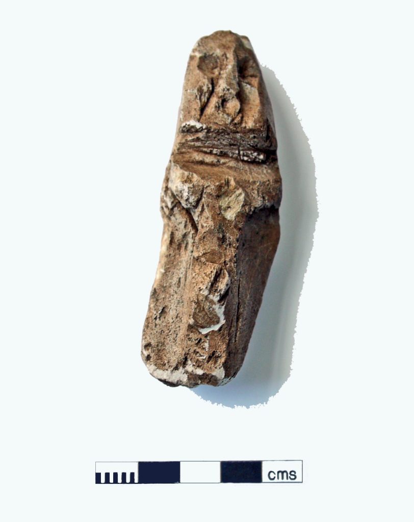
Both annexes by the main entrance had hearths; the hearth in the east annexe contained the charred remains of complete heads of barley. The destruction layers of this annexe contained a small steatite figurine. This object is roughly 9cm long and, from its size and shape, appears to have been carved from a fishing line sinker. This figure, with its clasped arms, round ‘blowing’ mouth and likely conical hat or helmet, has many similarities with figures suggested to represent Thor. The possibility that it was carved from a line sinker suggests associations with fishing, the sea and the wind, all aspects also associated with Thor.
The dates from Underhoull, which mostly fell into the 11th-13th century, as with Hamar, have been reassessed using Bayesian analysis (Swindles et al 2019). This study suggested the longhouse was constructed between 805-1050 cal AD and most probably between 880-1000 cal AD. Activity at the site probably ended between 1260-1380 cal AD, when there is evidence of peat growth on the paving around the upper end of the building. This end date possibly reflects evidence for climate change and settlement abandonment in other parts of the North Atlantic.
The Hamar and Underhoull excavations showed that these were not single-phase houses but settlements with long and complex histories. The Hamar pit house, so far unique in Scottish archaeology, also shows similarities with these structures. The end dates for both sites suggest the kind of settlement contraction seen across the North Atlantic at this period.
References
Bond, J M 2013 ‘Excavations at Hamar and Underhoull’, in Turner, V E, Bond, J M and Larsen, A-C (eds) Viking Unst: Excavation and Survey in Northern Shetland 2006–2010, Lerwick: Shetland Heritage Publications, 125-179.
Bond, J M and Dockrill, S J 2023 ‘Hamar and Underhoull, Unst: settlement in Northernmost Scotland’, in Horne, T, Pierce, E and Barrowman, R (eds) The Viking Age in Scotland, studies in Scottish Scandinavian Archaeology, Edinburgh University Press, Edinburgh, 85-97.
Dockrill, S J, Bond, J M, Turner, V E , Brown, L D, Bashford, D J, Cussans, J and Nicholson, R A 2010 Excavations at Old Scatness, Shetland Volume 1: The Pictish Village and Viking Settlement, Lerwick: Shetland Heritage Publications.
Swindles, G T, Outram, Z, Batt, C M, Hamilton, W D, Church, M J, Bond, J M Watson, E J, Cook, G T, Sin, T J, Newton A J and Dugmore, A J 2019 ‘Vikings, peat formation and settlement abandonment: a multi-method chronological approach from Shetland.’ Quaternary Science Reviews 210, 211-225.
Turner, V E, Bond, J M and Larsen, A-C 2013 Viking Unst: Excavation and Survey in Northern Shetland 2006–2010, Lerwick: Shetland Heritage Publications.