
What stone tool quarries on Shetland can tell us about life on the edge of Europe in the Neolithic
Gabriel Cooney and Will Megarry
The archaeology of Shetland remains poorly understood when compared to its neighbours, yet it boasts some of the best preserved prehistoric landscapes in the UK and Ireland. While large-scale buildings and architecture are less prominent, from early in the Neolithic communities in Shetland were investing a significant amount of time and effort in one monumental activity – the extraction and production of polished stone tools from reibeckite felsite, quarried from well-preserved and extensive quarry complex on the slopes of Ronas Hill, the highest point of the archipelago and adjacent areas at North Roe, Northmavine.
Since 2012, the North Roe Felsite Project (NRFP) has been working on this element of the Neolithic in Shetland. The project has been exploring the extraction and production of stone axes and knives and the grinding and polishing of these objects off site, their use and deposition, and asking wider questions about Shetland island communities on the edge of the Neolithic world (Megarry et al 2023, Cooney et al 2019).
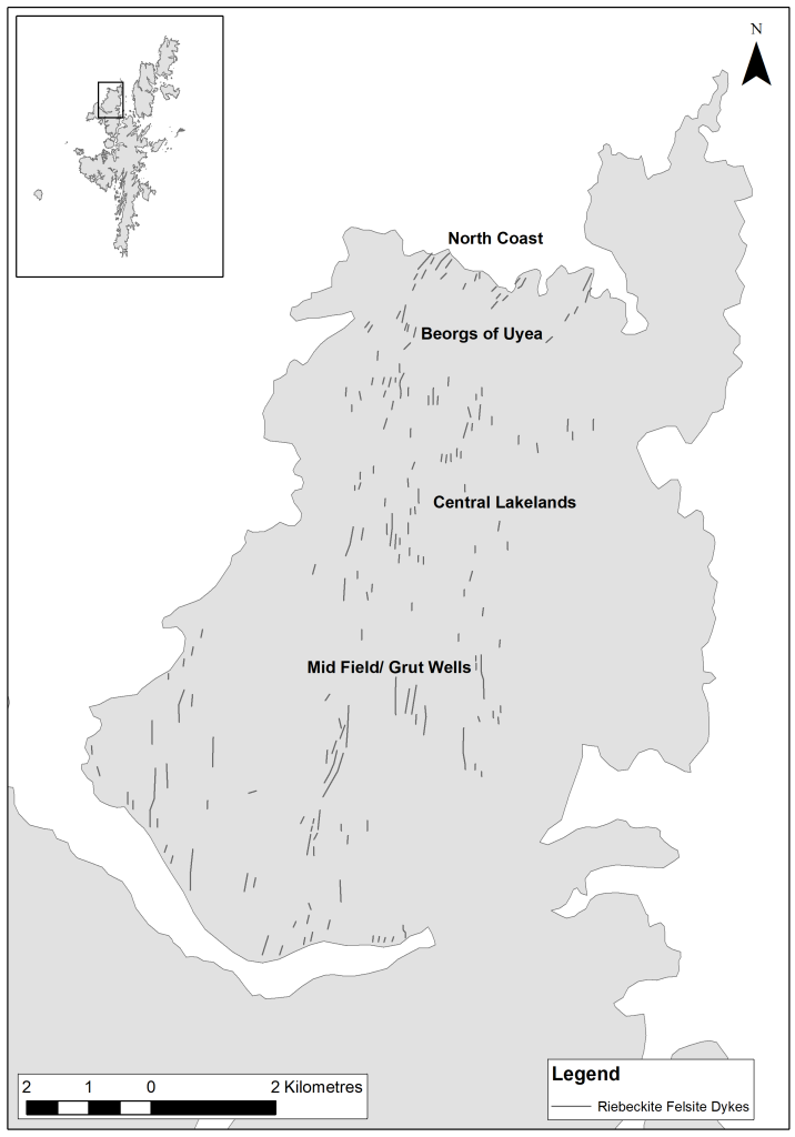
Reibeckite felsite is a visually distinctive blue-grey rock which outcrops as linear dykes intruding into the red granite landscape of North Roe. These dykes have varying widths, ranging from 0.5m to 5m with some dykes being traceable by intermittent exposure for over 1km. There are numerous quarries along these dykes and care seems to have gone into selecting felsite with distinctive markings including phenocrysts, spherulitc crystals and/or banding which remain visible on finished polished axes and knives.
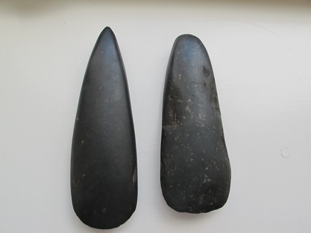
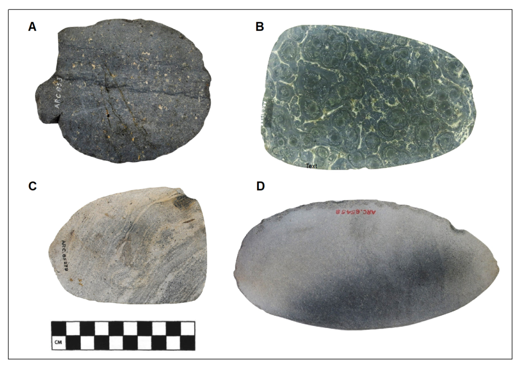
Reibeckite felsite was attributed as Group XXII in the Implement Petrology Committee (now the Implement Petrology Group) petrological grouping scheme (Ritchie and Scott 1988). The NRFP primarily focused on two areas in the complex, at the Beorgs of Uyea, to the north of Ronas Hill and Grut Wells, on its northeast slope. At the former, there is a considerable amount of surviving surface material or debitage spread across the site while the latter is more exposed and weathered with less surface material. Numerous quarry pits, where felsite had been extracted from the side of dykes or where the dyke had been completely removed, are present at both sites. The project undertook extensive surveys of both areas exploring the density and type of surface material and using survey equipment and drone imagery to create maps and plans (Megarry et al 2018).
In 2017, small excavations were undertaken across quarry pits at both sites in an effort to better understand the quarrying process. These trenches showed that while surface material is sparser at the more exposed site of Grut Wells, the depth of felsite extraction at Dyke 1 is extensive while the opposite was true at the Beorgs of Uyea.
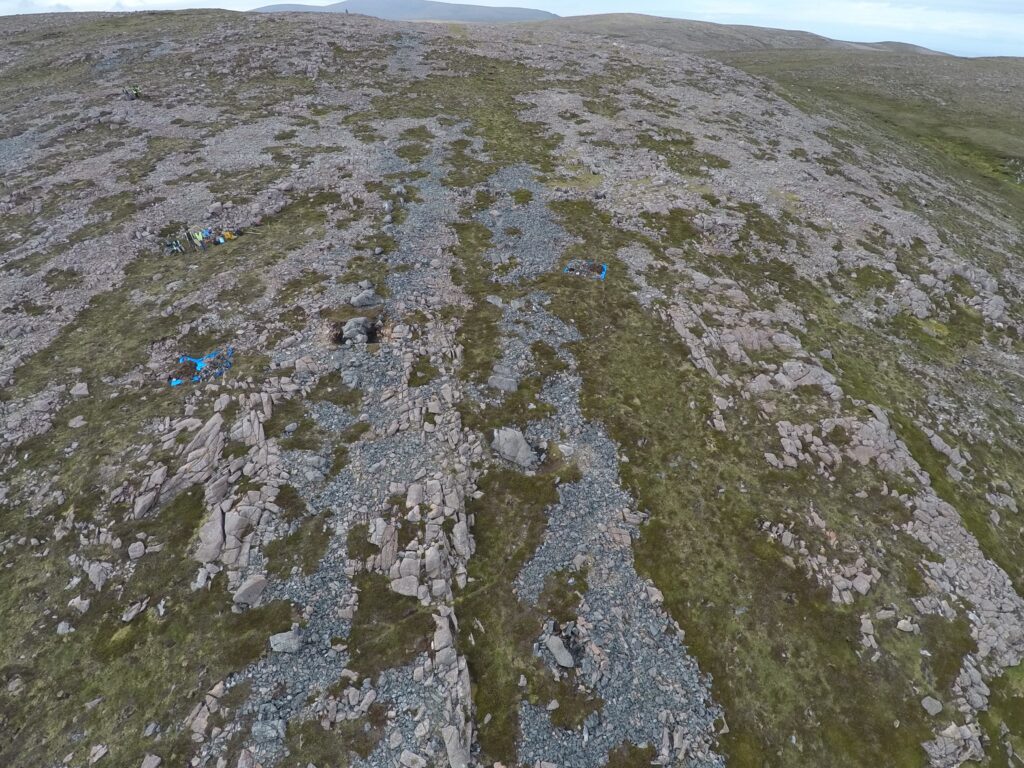
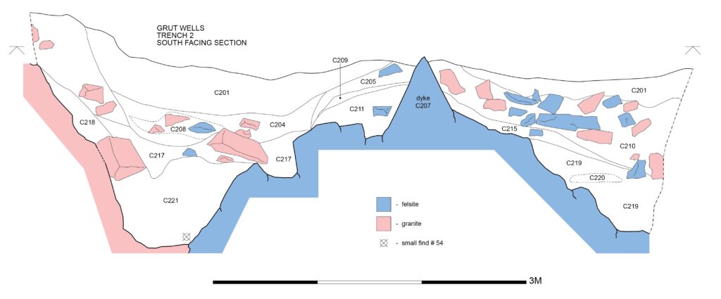
During these excavations charcoal was collected from the base of a trench next to a quarry face at Grut Wells which provided three dates, two of which dated to 4580±44 and 4670±33 (Cooney et al 2019, 60). These dates are similar to recent dates from contexts containing felsite tools found at Crooksetter and Modesty (Cummings 2017, 83, Sheridan 2021, 6-38). These dates indicate that the extraction and use of felsite was well established within a couple of centuries of the establishment of the first Neolithic communities on Shetland.
| Site | Lab Code | Conventional Age (BP) | Calibrated 14C Date (BC) |
| Modesty | SUERC-37997 | 4580 ± 35 | 3500–3110 |
| Crooksetter | SUERC-43349 | 4603 ± 27 | 3505–3360 |
| Crooksetter | SUERC-43353 | 4582 ± 24 | 3494–3350 |
| Grutt Wells | UBA-35547 | 4580 ± 44 | 3379–3265 |
| Grutt Wells | UBA-35548 | 4670 ± 33 | 3522–3366 |
Understanding the chaine opératoire or production process of felsite tool production is reliant on the archaeological interpretation of the enormous quantities of debitage or waste material present at quarry sites. An experimental programme was undertaken by members of the NRFP to assist with the interpretation of the surface surveys and this shed crucial insights into the knapping and morphological characteristics of this material. From an energy and human perspective it was noted that working felsite is more tiring than other lithologies, such as porcellanite. Quarrying often began beside the dyke, removing granite to access more of the felsite’s outer margin.
Although there is currently no direct evidence for exactly how large blocks were detached from dykes, it seems likely that a combination of techniques were employed. Fire setting does not appear to have been used. Once removed, felsite blocks were further reduced to roughouts in a series of stages (Megarry et al 2018). Further grinding and polishing appears to have occurred away from the quarries at settlements across the archipelago, and felsite tools have been found in large numbers, from the southernmost point of Sumburgh to the northernmost isle of Unst, suggesting an established island-wide distribution network.
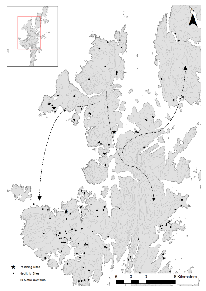
The quarries at North Roe share similarities to other contemporary Neolithic quarry sites including Great Langdale, Cumbria and Tievebulliagh, County Antrim (Cooney et al 2013). All are situated in places which are perceived as remote and isolated by contemporary standards and in all these cases, the chaine opératoire extends beyond the quarry complex. The quarries then form part of complex cultural landscapes. At the North Roe quarry complex, people in the Neolithic and later periods elaborated the surrounding landscape. At the Beorgs of Uyea a number of structures have been constructed in close proximity to the quarries including circular structures, a small chambered cairn and a gallery structure built up against an excavated dyke (Scott and Calder 1952). These structures, and their clear relationship to the quarries, are visible on drone imagery. On the ridge above the quarry, nearly 50 small standing stones of granite and sandstone were erected (Cooney et al 2019). Near Grut Wells, Archaeology Shetland have recently identified a series of structures located adjacent to or in close proximity to exploited dykes.
While Neolithic stone axe quarry complexes took time and effort to reach, they became the centres of local, regional and even international distribution networks. This is one of the many things which make quarries so important. They allow us to simultaneously explore the dichotomy of islands as both bounded units and as components of complex wider islandscapes. Quarries can also tell us about social organisation. Unlike structures, they are defined by what is taken from the landscape rather than what is added and the considerable investment of time and labour expended in the quarrying process is often overlooked in favour of large constructions. The importance of the North Roe quarry landscape continued into the Bronze Age and beyond. Excavations of a small structure east of and lower than Grut Wells, Dyke 1 produced a Bronze Age date of 1874-1672 cal BC (UBA-43169, 3422 BP ± 32), while pioneering work by Jennings has suggested substantial Iron Age occupation of the area (2021).
Finally, while we have discussed some of the evidence for felsite tool production and distribution on Shetland, it is worth concluding by noting the near complete absence of evidence for felsite exportation beyond the archipelago, suggesting a focus on this specific island world (Megarry et al 2021). This dynamic is also visible in the Neolithic pottery record from the archipelago which does not clearly follow styles evident elsewhere during the period (Sheridan 2012). If Shetland was in contact with the wider world of the North Atlantic, this contact does not appear to have be frequent. Was this insularity due to both geographical and social factors? Could remoteness have fed into a sense of island identity, which in turn reinforced insularity by apparently lessening contact beyond the islands?
You can read more about the NRFP project on the Society of Antiquaries of Scotland’s Society-Funded Research page.
Bibliography
Cooney, G, Warren, G and Ballin, T 2013 ‘Island quarries, island axeheads, and the Neolithic of Ireland and Britain’, North American Archaeologist 34(4), 409-431.
Cooney, G, Megarry, W, Markham, M, Gilhooley, B and O’Neill, B 2019 ‘Tangled up in blue: The role of reibeckite felsite in Neolithic Shetland’, in A Teather, P Topping and J Baczkowski (eds), Mining and Quarrying in Neolithic Europe: A Social Perspective, Oxford: Oxbow Books.
Cummings, V 2017 The Neolithic of Britain and Ireland, London: Routledge.
Jennings, S 2021 The Iron Age in the Neolithic Axe Factory, North Roe, Shetland, MLitt thesis, University of Highlands and Islands.
Megarry, W, Graham, C, Gilhooly, B, O’Neill, B, Sands, R, Nyland, A and Cooney, G 2018 ‘Debitage and drones: Classifying and characterising Neolithic stone tool production in the Shetland Islands using High Resolution Unmanned Aerial Vehicle imagery’, Drones 2(2), 12.
Megarry, W P, Markham, M, Gilhooley, B, O’Neill, B and Cooney, G 2021 ‘Insular networks: An exploration of material distribution, insularity and island identity on the edge of Europe in the Shetland Neolithic’, The Journal of Island and Coastal Archaeology 18, 612-634.
Ritchie, P R and Scott, J G 1988 ‘The petrological identification of stone axes from Shetland’, in McKClough, T H and Cummins, W A (eds), Stone Axe Studies 2, 85-91, London: Council for British Archaeology.
Scott, LG and Calder, CST 1952 ‘Notes on a chambered cairn, and a working gallery, on the Beorgs of Uyea, Northmaven, Shetland’, Proceedings of the Society of Antiquaries of Scotland 86, 171-177.
Sheridan, A 2012 ‘Neolithic Shetland: A view from the “mainland”’, in Mahler, D L (ed) The border of farming and the cultural markers, Copenhagen: The National Museum of Denmark, 6-36.