
Joanna Hambly and Scott Timpany
In May 2016, a resident of Benbecula in the Western Isles noticed stumps and twisted roots of trees far out in the intertidal zone during a very low tide at Lùb Bhàn, Lionacleit. Intertidal and sub-tidal peat containing sub-fossil trees are found all along the Atlantic coast of Uist and Benbecula. Around twenty sites are documented but because of the fickle nature of their visibility, which is dependent on the covering of sand that comes and goes, many more examples are known to the residents of these islands (Ritchie 1985). These examples are evidence of once widespread woodland that existed across the archipelago throughout the Mesolithic and into the Neolithic period.
Rapid sea level rise from around 5000 BC inundated these forests, but the marine and aeolian processes operating also created a new landscape of blown sand (machair) along the western seaboard. By the Bronze Age people living here would only have known the machair, which is synonymous with the Western Isles and with astonishingly well-preserved prehistoric archaeology. Much of the research into sea level change and machair development outlined in this introduction was conducted at Borve (Sidhean Bhuirg) very nearby to the site at Lionacleit (Edwards et al 2005, Ritchie 1985, Ritchie et al 2001, Whittington et al 1997). Lionacleit has added interest, not only because of the exposure of sub-fossil trees, but because locals had also noted a prehistoric saddle quern, quartz stone tools and animal bone embedded in intertidal peat much closer to the shore. The archaeological remains lie in the intertidal zone now because of coastal erosion, which since the 1970s has stripped away between 30m to 90m of machair in this location exposing the underlying buried land surface.
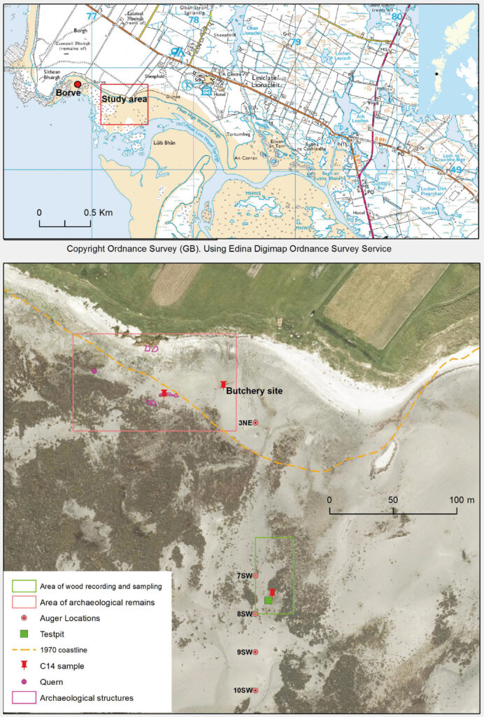
Working around low tides over a glorious week in May 2018, we applied a range of mapping and sampling techniques to investigate the submerged forest and intertidal archaeology of Lùb Bhàn, Lionacleit. The investigation was conducted by local volunteers, many of whom are experienced members of the Uist Community Archaeology Group, The SCAPE Trust, and Scott Timpany, palaeoecologist with the University of Highlands and Islands (UHI). S1 and S2 pupils from nearby Lionacleit School also assited in the project.
The submerged forest
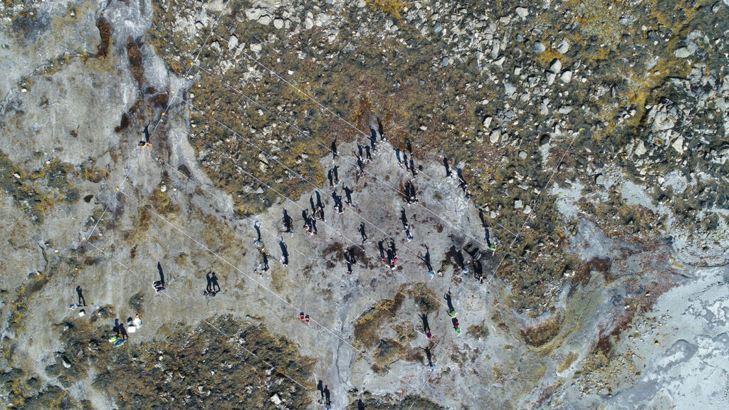
Roots and branches are visible from around 100m into the intertidal zone and we selected a representative sample area of 30m by 60m for detailed investigation of the tree remains and associated peat. Volunteers planned every visible wood fragment at a scale of 1:50 and sampled each piece of wood for microscopic identification. When the tide came in, we used the facilities kindly provided by the UHI campus at Lionacleit to start the microscopic identification of the tree types. Pupils from Lionacleit School helped us visualise the density of the forest by standing on each tree stump to recreate the life position of the tree.
We dug a test pit to look beneath the surface and sample for insect remains and plant macrofossils such as seeds and buds and took a 50cm long monolith tin sample through the peat and underlying sediments which was later sub-sampled for pollen, fungal spores, waterlogged plant remains, and material for radiocarbon dating.
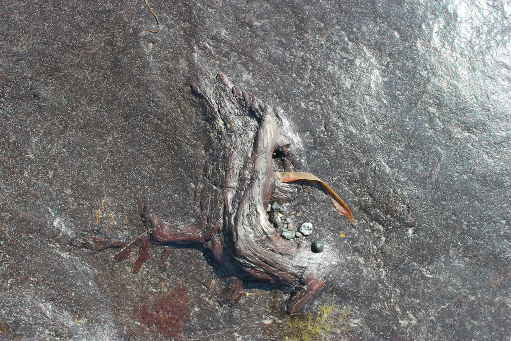
The results of the wood identification and analysis of pollen, waterlogged plant and insect remains, opens a window into a former world of wet, tangled willow (Salix) woodland with open grassy areas (Poaceae) and marshy ground favoured by sedges (Cyperaceae), meadowsweet (Filipendula), and cowbane (Cicuta virosa-type). Occasional birch (Betula) and Scot’s pine (Pinus sylvestris) indicate drier patches. This is the first identification of birch and willow wood remains in Benbecula and the first recording of Scot’s pine tree-remains in Uist with previous recordings of this tree in the Western Isles restricted to Harris (Fossitt 1996). The pollen from these trees become more common higher up and so later in the sequence. Specialist woodland floor beetles (Pterostichus strenuous) and species that prefer drier conditions (Amara sp.) underline the variety of habitats. The peat containing the sub-fossil trees dates from 6066-5931 cal BC [SUERC 85850] to 4043-3947 cal BC [SUERC 85852]. This tells us the woodland was growing in the late Mesolithic into the early Neolithic, and probably beyond, but the top of the peat sequence is truncated by marine erosion. A spike in microscopic charcoal around 4338-4084 cal BC [SUERC 85851] may signify the presence of people. Researchers at nearby Borve identified a sudden persistent increase of high charcoal to pollen ratios in peat samples from around 7000 years ago and have argued that Mesolithic populations may have had a greater than hitherto realised large-scale impact on vegetation (Edwards et al 2005).
The archaeology
A concentration of previously identified animal bone and quartz lithics were found in intertidal peat around 30m from the present-day shoreline. During the investigation, we realised that vestiges of walls and structures may also survive in the upper intertidal zone. They rest unconformably upon sand covered peat. A radiocarbon sample from peat beneath a wall returned an early Neolithic date of 3519-3365 cal BC (SUERC 85843). This gives a terminus post quem for the wall which is, however, much more likely to be later in date. The archaeological remains owe their survival to their recent exposure. Less than 50 years ago the animal bone and lithics were buried beneath machair and the possible structures would have been on the beach.
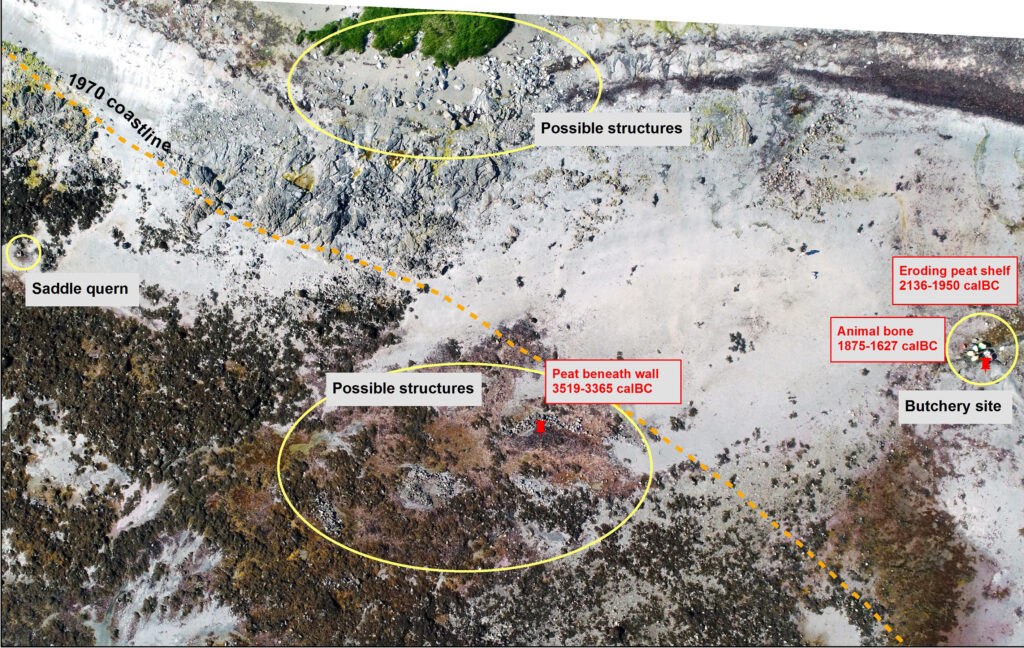
The peat bank within which the bone and quartz tools were embedded was obviously rapidly eroding and so we excavated and recovered 100% of the surviving remains. These turned out to be cattle bone from a single mature individual, over 5 years old, of small stature, standing at around 110cm. Bones from all parts of the skeleton were present, and those from the right forelimb articulated. A radiocarbon date returned from a sample of bone show the animal died in the Early Bronze Age between 1875-1627 cal BC (SUERC 85845). This is consistent with the date of the peat shelf from which the animal bone and struck lithics were eroding of 2136-1950 cal BC (SUERC 85844).
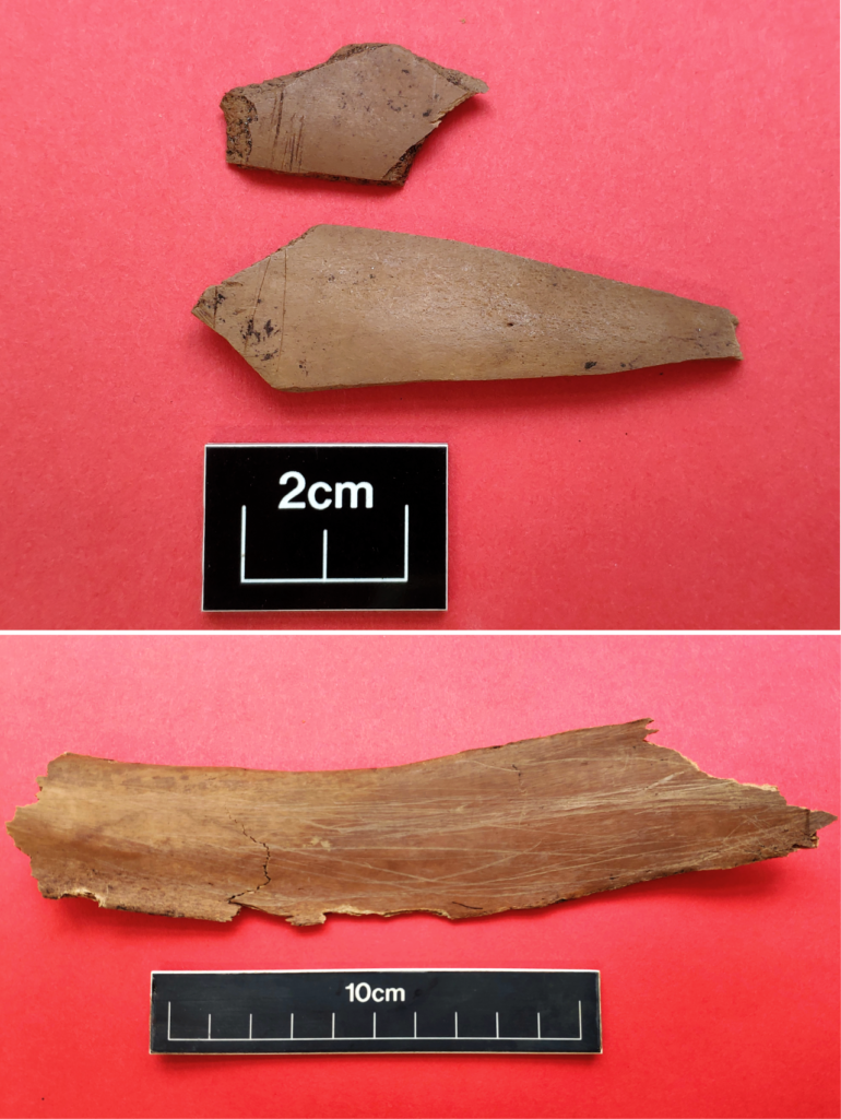
A significant feature of the bones was the presence of numerous cut marks. Groups of parallel cut marks are present on the skull, mandible, scapula, humerus and upon long bone shaft fragments, which have themselves been chopped in antiquity. A chatter mark from a tool skidding along a bone surface was noted, and the ribs are covered in multiple long scratches along the ventral surface, suggesting a scraping action along the length of the bone.
The smoking gun for the cut marks is the close association of twenty-nine freshly struck quartz lithics, several of which were found in direct contact with the bone. Many pieces had a distinctive colour combination of a blueish-grey centre becoming white towards the surface, suggesting they were struck from the same nodule or nodules derived from the same vein. Most of the assemblage is debitage; seven chips and twenty flakes; whereas two are tools; a side scraper, and one piece with edge retouched.
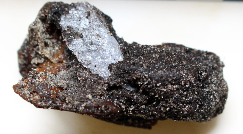
It looks very much like nodules of raw material were brought to the animal and struck on the fly. Unmodified flakes were expedient knives used for the butchering. The edge-retouched pieces may have been used for more robust work such as scraping the bones clean or cutting grooves into the bones to split them for marrow. The lithics were discarded when the job was done.
This compelling evidence of a single action in prehistory preserved in the archaeological record is extremely rare. A Late Neolithic butchery site in Skaill Bay, Mainland Orkney and articulated and butchered Neolithic cattle bone from Tofts Ness on Sanday, Orkney are the only two parallels in Scotland and neither have such closely associated lithics that can be linked to the action of butchery itself (Richards et al 2015, Dockrill 2007, 195-201).
Conclusion
These remains, hiding in plain sight until noticed by local residents, demonstrate the potential of the coastal and intertidal archaeological resource in bringing the distant past to life. In one small Benbecula bay lies the physical evidence of the landscape and environmental transformations of the Western Isles during early prehistory. The timespan over which this occurred coincides with the occupation of the island by people who witnessed, and possibly even influenced, large-scale vegetation change. The chance survival of an event, frozen in time, brings an immediacy to a Bronze Age community. The circumstances of discovery and ensuing investigation highlight the critical role of the local community in monitoring coastlines for the inevitable further exposure of archaeological remains along shorelines globally.
Acknowledgements
We would like to thank all the volunteers who made this project so enjoyable and productive. A big thank you to Caitriona MacCuish, Museum Development Officer at Museum nan Eilean and to the staff and S1 and S2 pupils of Sgoil Lionacleit for bringing the forest to life.
The animal bone and lithics information is based upon analysis by Catherine Smith, Mary Harman and Torben Bjarke Ballin.
A special thank you to Anne Corrance Monk and Simon Davies for bringing the site to our attention and for continuing to keep an eye on it.
References
Dockrill S 2007 Investigations in Sanday, Orkney, vol 2: Toft’s Ness, Sanday: An island landscape through 3000 years of prehistory, Kirkwall: The Orcadian Ltd.
Edwards K J, Whittington G and Ritchie W 2005 ‘The possible role of humans in the early stages of machair evolution: palaeoenvironmental investigations in the Outer Hebrides, Scotland’, Journal of Archaeological Science 32, 435-449.
Fossitt, J A 1996 ‘Late Quaternary Vegetation History of the Western Isles of Scotland’, The New Phytologist 132(1), 171-196.
Richards, C, Clarke, A, Ingrem, C, Mulville, J and Mainland, I 2015 ‘Containment, closure and red deer: a Late Neolithic butchery site at Skaill Bay, Mainland, Orkney’, Proceedings of the Society of Antiquaries of Scotland 145, 91-124.
Ritchie W, Whittington G and Edwards K J 2001 ‘Holocene changes in the physiography and vegetation of the Atlantic littoral of the Uists Outer Hebrides, Scotland’, Transactions of the Royal Society of Edinburgh: Earth Sciences 92, 121-136.
Ritchie, W 1985 ‘Inter-tidal and sub-tidal organic deposits and sea level changes in the Uists, Outer Hebrides’, Scottish Journal of Geology 21, 161-176.
Whittington, G and Edwards, K J 1997 ‘Evolution of a machair landscape: pollen and related studies from Benbecula, Outer Hebrides, Scotland’, Transactions of the Royal Society of Edinburgh: Earth Sciences 87, 515-531.