
The transition from the Palaeolithic to Mesolithic is characterised as the end of the glacial conditions of the Pleistocene to the mild conditions of the Holocene, with associated establishment of woodland cover (Hardy and Ballin 2024,13). Scottish sites and finds from the Palaeolithic have been dated to the Late Upper Palaeolithic from 12,700BC to 9800BC from typologies of lithics with parallels from Europe. From the end of the Palaeolithic the Mesolithic continues to around 4100BC. The end of the Palaeolithic is not purely signified by the climatic change but is also understood archaeologically through the changing stone tool technology and the production of microliths in the Mesolithic, a much finer composite stone tool technology than previously observed.
Throughout the Clyde Valley study area evidence of human presence through the Later Upper Palaeolithic and Mesolithic are identified by stone implements finds spots and stone working sites, as well as some evidence of occasional settlement at Howburn Farm (41356) (Ballin et al 2018) and Camps Valley (Cox and Marshall 2023), both in South Lanarkshire. The eagerly awaited publication of Howburn Farm, South Lanarkshire was released in 2018 interpreting the site with two phases of Upper Late Palaeolithic occupation, the Hamburgian period, beginning in 12,700BC, and the Feddermesser-Gruppen period, running onwards from 12,000BC to 10,800BC, as well as evidence of land use during the Mesolithic and Neolithic (Ballin et al 2018, 13). The publication discusses Howburn Farm as an occasional settlement site of people following migrating reindeer towards Norway (Ballin et al 2018, 116).
Unfortunately, these site types limit the understanding of overall occupation, as they are representative only of a narrow range of activities or tasks but utilising a landscape approach does provide information on these highly mobile communities. The array of Mesolithic sites in the Biggar Gap including Daer Valley (Ballin et al 2018), Biggar Common (Johnston 1997) and now Camps Valley and Woodend (Cox & Marshall 2023), provide us with insights into the routeway connecting the Tweed and Clyde rivers, which was longstanding from the Mesolithic and highlight repeated occasional settlement and continued use through to the Bronze Age. Early prehistoric routeways through upland landscapes have been explored through Wickham-Jones et al’s (2020) which is highly comparable to the sites at Daer Valley.
There is opportunity to further develop the understanding of these routeways by locating other occasional sites of occupation in the wider Clyde Valley. It has already been noted that the sites above are concentrated in South Lanarkshire due to the efforts of particularly interested parties, as there is further potential evidence towards Loch Lomond with a series of pits and hearths dated to the Mesolithic at Mid Ross (55497, Batey 2023, Beckett et al no date), there is likely to be other evidence not yet located and our current distribution may reflect where the Mesolithic and Palaeolithic have been looked for, rather than the true extent of activity from these periods in the region.
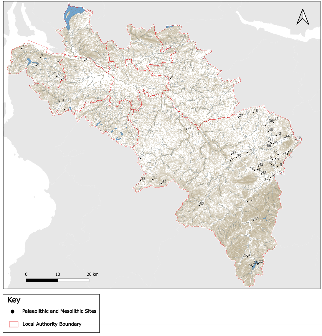
| id | Site Name | Co-ordinate |
| 1 | Craigmarloch | NS 34969 72191 |
| 2 | Gryffe | NS 27999 71001 |
| 3 | Gourock Golf Course | NS 23450 76420 |
| 4 | Quarrier’s Homes | NS 36100 66600 |
| 5 | Lawpark | NS 34000 68700 |
| 6 | Duchal Mains | NS 34600 67500 |
| 7 | Lurg Moor | NS 29400 73639 |
| 8 | Woodend Loch | NS 70700 66900 |
| 9 | Bishopton | NS 43300 72500 |
| 10 | Crook Hill | NS 35300 59500 |
| 11 | Wateryett | NS 37000 57000 |
| 12 | North Deanhead | NT 04401 48901 |
| 13 | Thankerton | NS 97400 37800 |
| 14 | Heavyside | NT 05500 37500 |
| 15 | Biggar, Bizzyberry Hill | NT 04680 39040 |
| 16 | Carwood Hill | NT 02950 40400 |
| 17 | Bagmoors | NS 95100 43400 |
| 18 | Mountblaw Farm | NS 97000 56200 |
| 19 | Cornhill | NT 02499 35501 |
| 20 | Cornhill | NT 02099 34700 |
| 21 | Brownsbank Farm | NT 07800 42700 |
| 22 | Daer Resevoir (Site 1) | NS 98600 08270 |
| 23 | Daer Resevoir (Site 2) | NS 98419 08020 |
| 24 | Daer Resevoir (Site 5) | NS 96867 07188 |
| 25 | Daer Valley (Site 85) | NS 95290 10319 |
| 26 | Weston Farm | NT 02600 46500 |
| 27 | Hare Hill | NS 92290 54629 |
| 28 | Woollen Burn | NS 65034 34822 |
| 29 | Hynshawland | NT 04899 42799 |
| 30 | East Yardhouses | NT 00800 51900 |
| 31 | South Trabax, Dunsyre | NT 03600 53700 |
| 32 | Howburn farm, Elsrickle | NT 08202 43616 |
| 33 | Avon Water | NS 61200 34600 |
| 34 | Carwood Farm | NT 02950 40400 |
| 35 | The Greens, Newbigging | NT 01999 47000 |
| 36 | Darby Burn | NT 03499 53000 |
| 37 | Lanark Race Course | NS 90100 42900 |
| 38 | Elsrickle, Cocklaw Farm | NT 04100 41400 |
| 39 | Charleston | NS 91700 41850 |
| 40 | Muirlea Farm | NT 03099 41241 |
| 41 | Quothquan Law Farm | NS 98300 38100 |
| 42 | Parkhouse | NS 98700 39099 |
| 43 | Annieston | NS 99600 36600 |
| 44 | Dunsyre | NT 07100 48100 |
| 45 | Daer Valley (Site 84) | NS 95290 10319 |
| 46 | Weston Farm | NT 02600 46500 |
| 47 | Camps Valley | NS 96998 21953 |
| 48 | Corse Law | NT 01800 50099 |
| 49 | Haughhead | NS 10602 47635 |
| 50 | Howburn | NT 08002 42996 |
| 51 | Hyndford Quarry | NS 89733 40765 |
| 52 | Kennox | NS 79846 26646 |
| 53 | Nairn Street | NS 75878 50859 |
| 54 | Powbrone Burn | NS 67903 33604 |
| 55 | Tod Hill | NS 61259 41443 |
| 56 | Weston Farm | NT 02860 46360 |
| 57 | Woodend | NS 95261 27804 |