
As discussed by Alexander in the 2015 essay The Iron Age sites of the period have been researched throughout the Clyde Valley, although the quality of these activities is varied. A wide range of settlement types belonging to the Iron Age reside within the Clyde Valley although there is discussion from other authors that the region has been largely overlooked in general research of the Iron Age in Scotland (Banks 2002, Murtagh 2014). The previous research which will be discussed in History of Research focused on hillforts and special sites, which is not reflective of the overall complexity of communities in the Iron Age and limits the understanding of communities throughout the Iron Age.
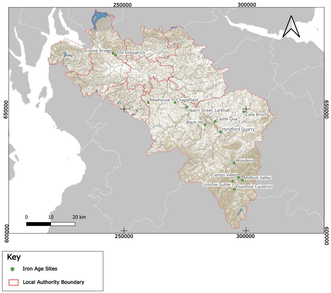
Since the production of the 2015 essay eight new sites attributed to the Iron Age have been discovered and intrusively investigated (Figure 1). Three waterlogged roundhouses were located at Hyndford Quarry within an area of bog which has allowed excellent preservation of the site. The wetland context of the roundhouses allowed excellent survival of organic material (O’Connell 2022). Four sites dated to the Iron Age were identified during construction of Clyde Windfarm in South Lanarkshire, an Iron Age enclosure was recorded at Woodend Hillfort (10440), while a single pit at Camps Valley were radiocarbon dated to the Iron Age. To the south a roundhouse was excavated with two long enclosures at Midlock Valley and the remains of a post-fence and non-ferrous metal working site recovered from Newton Plantation (Cox and Marshall 2023). A possible Iron Age rectangular structure at Nairn Street, Larkhall (96486, Mooney 2023), two roundhouses newly located at Chapelfield, Hamilton ( 99471, Barret 2023) and Newhouse, East Kilbride (69987, Hugget & Barret 2021).
Four known sites were also investigated, Castle Qua was confirmed as an Iron age D-shaped enclosure and Black Hill (10294) was excavated with multiperiod settlement with use during the Iron Age (Murtagh forthcoming). Two marine crannogs in the River Clyde, Old Kirkpatrick (7828) and Erskine (7863), to determine their use as domestic structures (Mackie et al 2022).
| id | Site Name | Site Type | Co-ordinate |
| 1 | Newhouse | Ring ditch and Roundhouse | NS 59955 52677 |
| 2 | Hyndford Quarry | Round Houses | NS 90609 41872 |
| 3 | Chapelfield | Enclosure; Ring Ditch; Pits; Post-holes; Pottery | NS 70932 52643 |
| 4 | Erskine Bridge | Crannog | NS 45483 72902 |
| 5 | Old Kirkpatrick | Crannog | NS 46558 72111 |
| 6 | Nairn Street, Larkhall | Building | NS 75878 50859 |
| 7 | Woodend | Enclosed Settlement; Metal Working Site | NS 95184 27800 |
| 8 | Midlock Valley | Roundhouse, Ring ditch, Structure | NS 98513 20762 |
| 9 | Camps Valley | Pit | NS 96997 21953 |
| 10 | Bonnyton Moor | Roundhouse; Enclosure | NS 541 522 |
| 11 | Annieston | Ring Ditch | NS 001 365 |
| 12 | Castlehill, Gibblaston | Fort | NS 3458 6605 |
| 13 | Marshall Moor | Fort | NS 3721 6257 |
| 14 | Craigmarloch | Fort | NS 3442 7185 |
| 15 | Walls Hill | Fort | NS 4117 5880 |
| 16 | Barr Hill | Fort | NS 4094 6365 |
| 17 | Corslie Hill | Fort | NS 4056 6902 |
| 18 | Oakshaw, Paisley | Fort | NS 477 640 |
| 19 | Dunwan | Fort | NS 5468 4894 |
| 20 | Duncarnock | Fort | NS 5010 5580 |
| 21 | Dechmont Hill | Fort | NS 656 582 |
| 22 | Double Dykes | Fort | NS 7647 4793 |
| 23 | Black Hill | Fort | NS 8318 4350 |
| 24 | Arbory Hill | Fort | NS 9445 2379 |
| 25 | Cow Castle | Fort | NS 0425 3311 |
| 26 | Quothquan Law | Fort | NS 9882 3842 |
| 27 | Chester Hill | Fort | NS 9532 3953 |
| 28 | Fallburn | Fort | NS 9619 3674 |
| 29 | St John’s Kirk | Fort | NS 9796 3674 |
| 30 | Caringryffe | Fort | NS 9429 4116 |
| 31 | Meikle Reive | Fort | NS 6392 7893 |
| 32 | Carman | Fort | NS 3720 7944 |
| 33 | Sheep Hill | Fort | NS 4348 7440 |
| 34 | Dumbarton Rock | Fort | NS 3998 7448 |
| 35 | Castle Hill, Bar Hill | Fort | NS 7091 7610 |
| 36 | Park Knowe | Enclosure | NS 9697 3660 |
| 37 | Shiels | Enclosure | NS 5259 6629 |
| 38 | Braehead | Earthwork | NS 5259 6629 |
| 39 | Pollok Park | Earthwork | NS 5566 6263 |
| 40 | Queen’s Park | Earthwork | NS 578 621 |
| 41 | Byreshill | Earthwork | NS 5055 6477 |
| 42 | Rosshall | Earthwork | NS 5066 6314 |
| 43 | Cadzow | Earthwork | NS 7343 5347 |
| 44 | Hillhead | Settlement | NS 9816 4018 |
| 45 | Knapps | Homestead | NS 3693 6884 |
| 46 | Knockmade Hill | Homestead | NS 3524 6182 |
| 47 | Middleton | Homestead | NS 494 542 |
| 48 | Gallowflat | Homestead | NS 6230 6158 |
| 49 | Dumbuie | Dun | NS 4218 7517 |
| 50 | Calla | Brock | NS 9911 4884 |
| 51 | Castle Semple Loch | Crannog | NS 360 590 |
| 52 | Dumbuck | Crannog | NS 4157 7392 |
| 53 | Langbank West | Crannog | NS 3813 7355 |
| 54 | Langbank East | Crannog | NS 4050 7328 |
| 55 | Erskine | Crannog | NS 4554 7288 |
| 56 | Erskine Ferry | Crannog | NS 4656 7211 |
| 57 | Lochend Loch | Crannog | NS 7065 6618 |
| 58 | Bishop Loch | Crannog | NS 687 688 |
| 59 | Hyndford | Crannog | NS 9061 4187 |
| 60 | Wester Yardhouses | Souterrain | NT 0042 5079 |
| 61 | Law of Mauldslie | Souterrain | NS 8214 5146 |
| 62 | Meikle Cloak | Cave | NS 3434 6068 |
| 63 | Auld Wive’s Lifts | Erratic Boulder | NS 5818 7646 |
| 64 | Clochodrick | Erratic Boulder | NS 3736 6127 |