Antoninus Pius’ decision to reverse his predecessor’s policy and move the frontier in Britain north seems to have been taken very soon after his accession in AD 138. The governor responsible, Q. Lollius Urbicus (Historia Augusta Antoninus Pius V), is attested building at both Corbridge in AD 139–40 (Roman Inscriptions of Britain 1147; 1148) and Balmuildy presumably shortly thereafter (Roman Inscriptions of Britain 2191 and 2192) as his victory is celebrated on coins issued late in AD 142 (Royal Imperial Coinage Antoninus Pius, 743–5). There has been some debate about the reasons for this dramatic change of policy, though it is now widely agreed that the new emperor, who lacked military experience and reputation, needed the prestige that such a military victory would bring (eg Hanson and Maxwell 1986, 60–4; Breeze 2006, 12–14). He may also have used possible local unrest in the frontier zone to prompt military action here rather than elsewhere in the Empire.


The reason that the forts on the Antonine Wall are so much more closely spaced than those on Hadrian’s Wall or, indeed, on any other Roman frontier, requires explanation, regardless of whether this represents the original plan or came about as the result of changes made during the construction process (see Planning and Building the Wall). It implies an increasing concern for border security, and the suggestion that the building of the Wall sparked a hostile local reaction is a potentially attractive explanation (Hanson 2020b). The same argument may apply to the postulated change from an original intention to build the Wall in stone, in order to speed up construction (Hodgson 2020).
There have long been problems with the chronology of the northern frontier in the mid-later second century, with disagreements about the length of occupation of the Wall and the number of phases involved. For a time, there appeared to be a consensus that there were two phases of Antonine occupation in Scotland which ended in around AD 164, based on the latest dated stratified coin from the Wall (Hanson and Maxwell 1986, ch 7). However, Hodgson (1995; 2009a) put forward a cogent case for dismissing the existence of a second Antonine phase, with the beginning of the end of the occupation by AD 158, the epigraphically attested date for the refurbishment of the curtain of Hadrian’s Wall (Roman Inscriptions of Britain 1389). He noted that hardly any of the excavated sites have provided unequivocal evidence of a second Antonine occupation following a period of abandonment. Hodgson suggested that the minor structural changes attested need be no more than piecemeal alterations and repairs to predominantly timber buildings.
He further argued that where two Antonine phases could be identified, they reflect changes in the deployment of troops after the addition of more forts to the Wall, rather than indicating any later reoccupation. This interpretation of the dating evidence has been widely accepted (eg Breeze 2006, 167; Keppie 2009, 1136), though the timescale for the process of abandonment seems uncomfortably lengthy, so that Hodgson was forced to postulate either a phased withdrawal or the occasional use of certain sites as outposts of Hadrian’s Wall. If this re-dating is combined with a return to the concept of the Wall as a unitary construction (see Planning and Building the Wall), then an alternative explanation must be found for the more persuasive structural indications of two phases, such as the rebuilding of the headquarters building (principia) and commander’s quarters (praetorium) at Mumrills.
For an interactive map of sites along the Antonine Wall, please click here
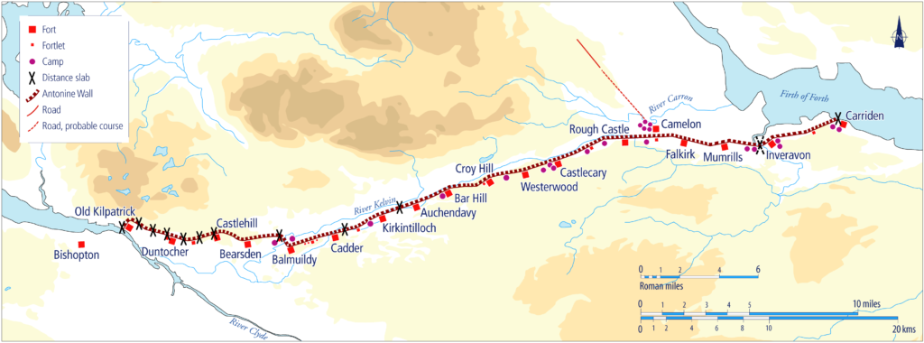
The identification of pottery with strong North African influences from various sites on the Wall (notably Mumrills, Croy Hill, Bar Hill, Bearsden, Duntocher and Old Kilpatrick), some of which was clearly of local manufacture, may indicate the presence of troops who originated from or had served in that region (Swan 1999). The most likely historical context for their presence is the return of a task force previously withdrawn to assist in Pius’ Mauretanian war in around AD 149/50, or slightly later, according to a series of diplomas from North Africa (Eck and Pangerl 2016; Breeze 2016b, 118–19). There is currently no independent evidence to support the suggestion that the return of these troops was linked to a hiatus in Wall building and the decision to build annexes, which would imply a lengthy delay in the whole construction programme (see Annexes).
The reasons for the abandonment of the Wall are no more certain, particularly now that a link with the end of the reign of Pius in AD 161 appears less chronologically sustainable. There is evidence to suggest that the decision was both ordered and controlled, involving the deliberate demolition of forts followed by careful tidying up and the removal of items of value. This included the infilling of wells at Old Kilpatrick and Bar Hill (Miller 1928, 23; Robertson et al 1975, 14), and the careful removal and burial of some of the Distance Stones, perhaps reflecting some ritual acts (Keppie 1998, 51–2 and 67; Breeze and Ferris 2016).
Hodgson suggests that the withdrawal from Scotland was a reaction to local opposition that was greater than could be contained by the forces then available because of military demands elsewhere in Europe (Hodgson 1995, 42–3; Hodgson 2009). The geographical focus of that opposition appears to have been south-west Scotland, where the relative lack of Roman material in Iron Age settlement sites has been noted (Wilson 2003, 113–14). The need for closer control in an area which remained insecure during the Antonine period is reflected in the enhanced disposition of well-defended fortlets throughout the occupation (Symonds 2017, 81–90). Continued hostile opposition is suggested both by the number of temporary camps that appear to date to this period and the fate of the fort at Birrens (Jones 2011, 123; Hanson and Maxwell 1986, 145). However, the most recent analysis puts greater emphasis on a shortage of manpower, which had been stretched throughout the Antonine occupation. It links the withdrawal to the dispatch of troops from all three British legions to Germany in AD 158 to assist with the reconfiguration of the frontier there (Hanson and Breeze 2020b).
Research issues
- Continue to examine the context of the building of the Antonine Wall, its occupation and abandonment, including a review of the African-style pottery and its stratigraphy.
- Undertake research to see if it is possible to identify vessels used in cooking in the North African style in the forts along the Danube that also provided other troops for service in the Mauretanian War.
- Undertake re-analysis of diplomas, and study any new ones found, to ascertain links between soldiers on the Antonine Wall and northern Africa.