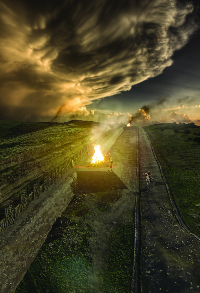
Six ‘expansions’, so-called because they consist of a southern extension of the rampart, were discovered along the line of the Wall in the 1890s (GAS 1899, 77–9, 84–5 and 107). Their purpose is uncertain but they may have been associated with long-distance signalling.
Expansions occur in pairs: one pair on each side of the fort at Rough Castle, referred to as Tentfield East and West and Bonnyside East and West, and one pair on the western slope of Croy Hill. Inveravon has been interpreted as a seventh (Dunwell and Ralston 1995, 526–30 and 567–9), but the north-south dimensions of the cobble base are too large by comparison with the other examples while the discovery of a posthole would be more appropriate if the cobbling were to be identified as the rampart of a small fort (see Forts).
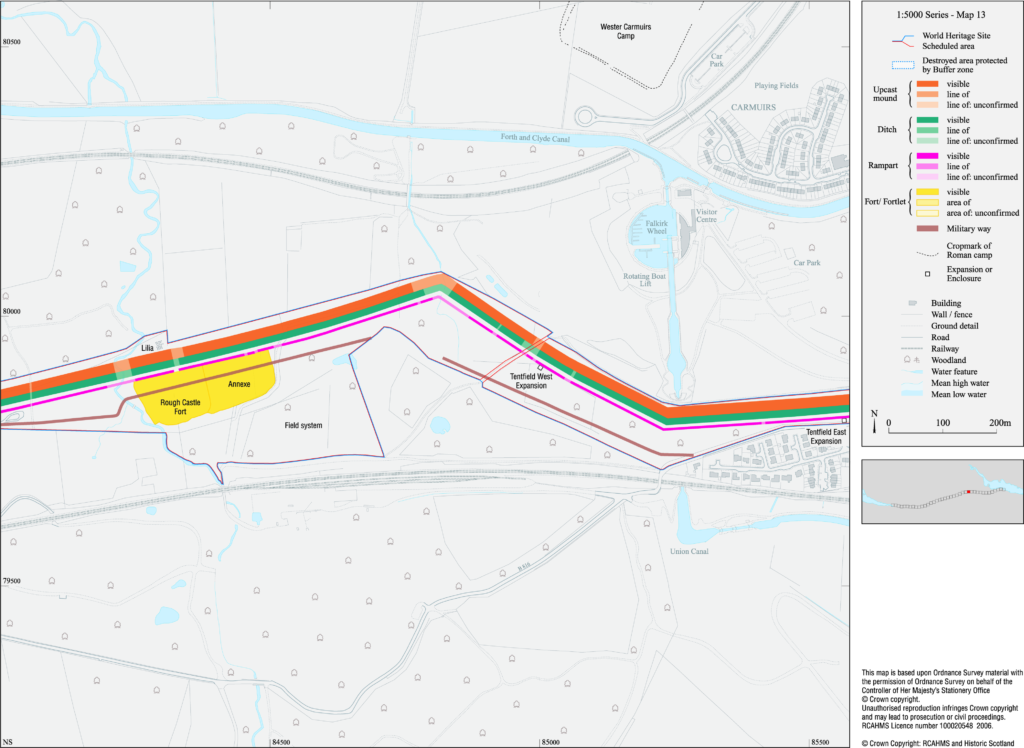
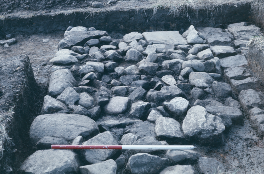
Each expansion consisted of a turf mound on a cobble base some 5.2m square attached to the rear of the Wall rampart after its construction (GAS 1899, 77–9 and 84–5; Steer 1957). Steer suggested that the superstructure of the expansion at Bonnyside East was bonded with the Wall rampart and so built at the same time. However, this interpretation is not as clearly supported by his section drawings as he implies (Hanson 2020b, fn 57). Furthermore the base of the expansion was not bonded with the Wall, which implies that it was secondary; as does the fact that it overlay a quarry pit of the Military Way. The purpose of the expansions is not certain, though it seems most likely to have been related to long-distance signalling using fire, given the quantities of burnt material found at Bonnyside East. The two pairs of expansions on either side of Rough Castle may have been intended to signal to the outpost forts in the north, while the pair on Croy Hill may have faced south towards the fort at Bothwellhaugh in Clydesdale.
Only three so-called minor enclosures are known along the Wall; all were discovered through aerial photography, two to the west of the fortlet at Wilderness Plantation and one to its east, referred to as Buchley, Wilderness West and Wilderness East.
The spacing between the enclosures and the fortlet varies between 260–295m, rather less than one-sixth of a Roman mile. Only one example has been excavated; it consisted of a single ditch surrounding a very slight rampart of dumped-earth, internally revetted with turf, enclosing an area of approximately 5.5m square (Hanson and Maxwell 1983). Its construction does not seem to have been integrated with that of the Wall rampart, though the turf had not been stripped from the interior prior to its construction. Neither an entrance nor any internal structure was found, so its purpose remains a mystery.
It has long been argued that watchtowers ought to exist on the Wall, on analogy with linear frontiers elsewhere (eg Gillam 1975, 55–6), but they continue to remain elusive. It was thought that the small enclosures near Wilderness Plantation were potential candidates, but excavation failed to find any supporting structural evidence. Two other possible candidates have been suggested, but neither are entirely convincing. A penannular ditched enclosure 26.5m in diameter was located on aerial photographs just to the south of the Wall at Garnhall. Excavation identified an internal posthole structure interpreted as a tower around 4m square (Woolliscroft 2008, 145–57 and 163–7). However, the irregularity and shallow depth of the postholes, the absence of associated Roman material and the fact that its ditch was partly overlain by the Military Way suggests that it may instead be an Iron Age structure. A rectangular interruption in the clay cheek at the rear of the Wall in Callendar Park was interpreted as a post-setting for a timber tower (Bailey 1995, 585–6 and Illus 3), but the structural stability of such a post is questionable, since the batter of the rampart would mean that very little of it would have been supported by rampart material, and no corresponding setting in the body of the rampart was located. However, evidence of occupation was also found immediately to the rear of the Wall some 100m to the east, where a two-phase hearth and a possible lean-to timber structure were identified, indicating some form of Roman activity nearby (Bailey 1995, 580 and 586). That no towers were built on the Wall is now being more widely suggested (Breeze 2019, 96–7; Hanson and Breeze 2020a, 23), though it is possible that timber towers could yet be located within the body of the rampart.
Other occasional enigmatic features have been recorded attached to the rampart. A 12m long, narrow stone platform added to the back of the rampart at Tollpark was regarded as too massive and regular to constitute a repair (Keppie and Breeze 1981, 239–40). One suggestion is that it served as a means of accessing the Wall top (Robertson 2015, 18), though the absence of a turf stack above it and the presence of extensive burning on its surface would not support such an interpretation. A similar discovery was recorded some 874m to the west at Garnhall (Woolliscroft 2008, 158–62), though its irregular remains and location next to a culvert may hint at an association with repairs.
Research issues
- Take any opportunities to seek other examples of expansions, small enclosures or other minor structures attached to the Wall rampart and investigate their functions and history.
- Undertake GIS analysis to explore the feasibility of long-distance signalling from the expansions.
- Seek to establish whether or not there were towers along the line of the Wall, including geophysical survey in lengths where the wall base has been destroyed to seek postholes of possible towers.