Evidence for Early Neolithic funerary practices comes mostly from non-megalithic long mounds, of which four examples – all in Scottish Borders – were listed by Ian Kinnes in his publication, Non-Megalithic Long Barrows and Allied Structures in the British Neolithic (Kinnes 1992a; see also Kinnes 1992b and Henshall 1972, 404, 459, 468, 479–80).
| Findspot | NGR | Trove ID | Reference |
| Harlaw Muir, Scottish Borders | NT 179546 | 50228 | Henshall 1972, 468; Kinnes 1992a, 17; 1992b, 84 |
| The Mutiny Stones, Scottish Borders | NT 62257 59025 | 60309 | Henshall 1992, 404; Kinnes 1992a, 17; 1992b, 83 |
| Langknowe (Long Knowe), Scottish Borders | NY 5272 8621 | 67938 | Henshall 1992, 479; Kinnes 1992a, 17; 1992b, 84 |
| Caverton Hillhead (Black Dike), Scottish Borders | NT 7328 2749 | 58269 | Henshall 1992, 480; Kinnes 1992a, 17; 1992b, 84 |
All are impressive stone cairns, located on hilltops or hill slopes at elevations between 160 and 370 metres above sea level. Caverton Hillhead, has been destroyed and Harlaw Muir, partly destroyed. The Mutiny Stones in the Lammermuir Hills, and Langknowe, in Liddisdale, are trapezoidal and the former is a massive, around 82 metres long by an estimated 21 m wide. Explorations during the 19th and early 20th centuries failed to produce artefacts or any meaningful dating evidence. A wall facing was discovered in 1924 at The Mutiny Stones and at Langknowe, structures described as ‘cists’ were found. However these are likely to be secondary additions of Early Bronze Age date.
In addition to these four long cairns, two previously unrecognised earth-and-stone long barrows were excavated as part of the A1 upgrade work by GUARD, at Eweford West and Pencraig Hill, East Lothian (Lelong and MacGregor 2007). These excavations provided invaluable information about the age, construction and use of these monuments, and demonstrated that non-megalithic long mounds are not exclusively located at relatively high altitudes. Moreover, the Eweford West long mound is within 3 km of the large, Early Neolithic communal house (‘hall’) on Doon Hill.
The Eweford West monument (Lelong and MacGregor 2007) has a complex history. It started out as a low, small, sub-circular mound placed on a natural glacial bank. A large pit was then dug into its centre, some kind of burning occurred, and burnt stones were placed in the pit along with unburnt cattle bones, one dated to 3960–3780 cal BC (SUERC-5280, 5065±35 BP). Meanwhile, around the same time, a pit 30 metres away was dug and seven pot sherds in the Carinated Bowl tradition were placed in it. Subsequently, the mound was enlarged to a width of 20 metres using turves, and cutting into this mound two rectangular timber mortuary structures were constructed, one after the other, with the second being built after the first was burnt down. The second was also burnt down. Running parallel with these was a trench for a timber façade, which showed two phases of construction, the first followed by burning down, possibly at the time when the first mortuary structure was burnt down. The rebuilt façade was left intact. Finally, the mound was built up over the remains of the mortuary structures, to create a long, rectangular, stone-revetted mound. Bone from one adult and one immature individual was found in the first structure, while in the second were the remains of at least two adults and probably those of a newborn baby. One of the adults had been laid out for the skin to decay before the structure was burnt down. Carinated Bowl pottery is associated with the second structure and sherds were found scattered over the mound on which the structures had been built; in the area of the façade; and in one of the quarry pits dug to provide mound material. An Arran pitchstone bladelet was also found in one of the quarry pits. The several radiocarbon dates obtained for this monument confirm that it was in use during the first quarter of the fourth millennium BC. Just 0.5 grams of cremated human bone was also found in a small pit near the long mound. A sample of burnt hazelnut shell from the pit produced a radiocarbon date of 3640-3370 cal BC (SUERC-5338, 4740±40 BP), and if this was contemporary with the bone, it indicates that the use of the area for depositing the dead – or at least for rituals associated with human remains – continued after the long mound had been built.
The monument at Pencraig Hill (Lelong and MacGregor 2007, 32–41), with its uninterrupted views to Traprain Law and the Lammermuir Hills to the south, also has a complex structural history. It appears to have started its life as a small, axehead-shaped mound constructed on cleared land where preparatory fires had been lit. A small, open-ended wooden structure was set into it, clay was then laid possibly as a flooring inside this structure before further fires were lit and the structure was burnt down. This activity is dated to 3950–3710 cal BC (SUERC-7663, 5025±35 BP). Then a more monumental, trapezoidal enclosure was constructed around this. Inserted into its long side ditches was a substantial screen made from oak planks fastened with pegs of pine, alder or hazel. A façade of oak posts was added at the broad end, terminating in two massive oak posts. A moveable entrance to the enclosed area, using a screen of wattle and daub, was created and this activity is dated to 3800–3650 cal BC (SUERC-7658, 4945±35 BP). Within the enclosed area a rectangular mortuary structure was constructed, into (or onto) which they laid at least two human corpses, one being an adult male. After an interval, this was also burnt down. Four samples of oak bark charcoal produced consistent dates around 3950–3650 cal BC. Evidently the trapezoidal enclosure, with its façade, was also burnt down – possibly at the same time as the mortuary structure. Unlike Eweford West, however, the burnt remains do not seem to have been subsequently covered over by a mound – or, at least, no evidence for a mound was found.
Ian Kinnes’ distribution map of non-megalithic long mounds, to which the two East Lothian examples have been added, along with Biggar Common in South Lanarkshire, places these monuments in relation to other examples in Britain and shows that they are part of a widespread Early Neolithic tradition, with Langknowe lying at the west end of a cluster of such sites in and around the Cheviot Hills.

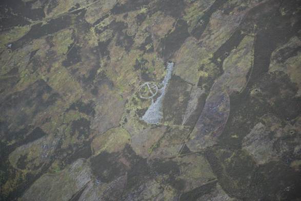
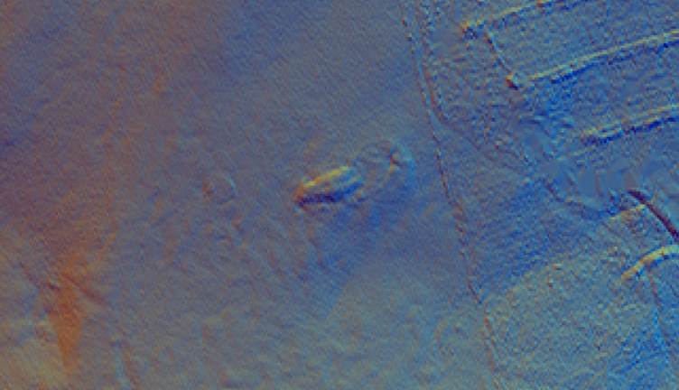
Further non-megalithic long mounds may well exist in the SESARF area, and a search of aerial photographs and lidar scans is recommended. In Scottish Borders region, a long cairn at Broughton Knowe is identified with no further details; the identification is based on aerial photographs. Strat Halliday (pers. comm.) has, however, confirmed that it is a good candidate, and has mentioned other possible examples, from aerial photographs, at Sheriff Muir (but could be an un-mounded mortuary enclosure rather than a barrow) and Ninewells Mains.
It is clear, from the excavation of Eweford West and Pencraig Hill, and from Early Neolithic non-megalithic long mounds elsewhere (for example Lochhill and Slewcairn: Sheridan 2023), that only very small numbers of people ended up in these monuments. These monuments were not designed to be the final resting places of the whole community, or to be added to sequentially. It may be that the few people buried in these monuments were selected by the community to be ‘the special dead’, and treated as though they were the founding fathers/mothers of the community, memorialised within these striking monuments in the landscape. The creation of these monuments, like the construction of the large Early Neolithic ‘halls’ such as at Doon Hill, will have involved the efforts of many people. As with the ‘halls’, long mounds will have served to signal the identity of these farmers, strengthening and expressing community ties. The local community could have used the monuments not just as a bold statement of their presence and identity – differentiating themselves spectacularly from indigenous groups of hunter-fisher-foragers who might still be around, and for whom such a funerary practice would be utterly alien – but also to justify their occupation of the land by claiming ‘This is my land because my ancestors are buried here’.
As far as we can tell from the admittedly fairly sparse dating evidence, the construction of these non-megalithic long monuments appears to be a phenomenon associated just with the first few generations of farmers in south-east Scotland. Unlike elsewhere in the south of Scotland, where an evolution from non-megalithic to megalithic monuments can be traced (Sheridan 2023), these long monuments were not succeeded by the construction of megalithic monuments. Similarly, there is no evidence for the use of Early Neolithic non-megalithic round mounds that are found elsewhere in Scotland (Sheridan 2010).
But what happened to all the other people who died during the Early Neolithic, if these monuments were only for the very few?
Luckily, developer-funded archaeology has provided an important clue. In 2012, during a watching brief for the installation of a water main, archaeologists from CFA Archaeology discovered a pit on the slope of Duns Law. This contained (along with later Beaker finds) sherds of two Carinated Bowl pots, a stone axehead (of local greywacke) with its blade rendered unusable, and cremated human bone fragments, three of which produced radiocarbon dates of 3942–3708 cal BC, 3786–3657 cal BC and 3768–3651 cal BC respectively (SUERC-43923, 42417, 42416: see Anderson 2017, table 5 and illus 6 for details). It appears that three Early Neolithic individuals are represented. With the exception of a second, smaller pit nearby, no other features were found and it is unclear whether this pit had been part of a settlement or not, although such an interpretation would be plausible. It does demonstrate, however, a funerary practice that is far harder to spot or to search for: cremation and deposition in a simple pit. It remains to be seen whether this was the standard Early Neolithic funerary rite for those not chosen for a monumental resting place.