The emphasis on settlement types in the research of Iron Age Scotland and its implication of social dynamics has been argued by academics in the previous century. Iron Age settlements are generally split into two categories, enclosed and unenclosed. The decision of why Iron Age people chose to enclose a settlement has been the dominant question within Iron Age research (Alexander 2015, 4). Unenclosed settlements refers to roundhouses or other structures which are not retained by a large earthen ditch and bank or timber boundaries, while enclosed settlements, such as hillforts have varying numbers of palisades, ditches and ramparts perhaps as a defensive feature.
Unenclosed Settlements
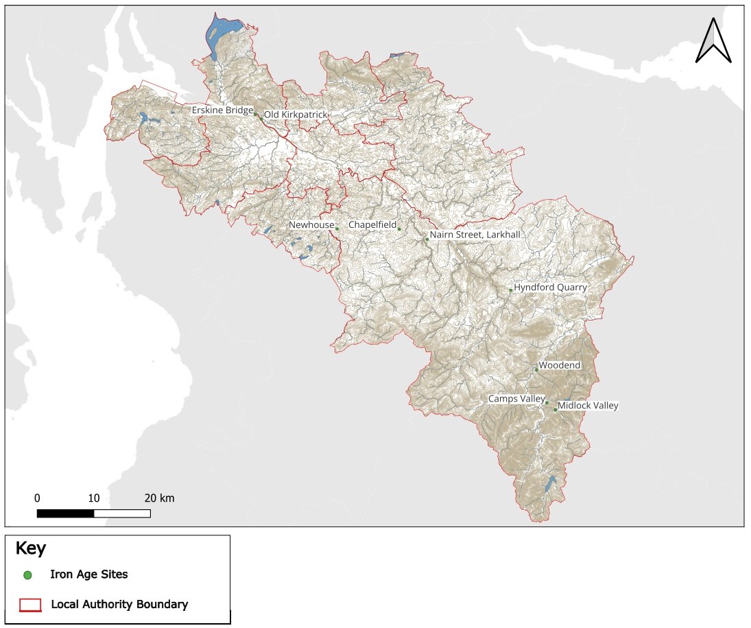
Excavation Nairn Street, Larkhall (96486) discovered material within the remains of two possible structures produced two radiocarbon dates of 19 cal BC – cal AD 130 (SUERC-62289) and AD 51 – 214 (SUERC-62286), from a fill deposit in gully and post hole, respectively. This Roman/Iron Age date range indicated re-occupation cut into an earlier Bronze Age roundhouse (Mooney 2023, 17). The possible Iron Age structure was not identified during the initial excavation of the site but located during post-excavation analysis as a rectangular shaped alignment of gullies and postholes. Material recovered from the structure were mostly Bronze Age, which belonged to the earlier roundhouse. The only identifying feature from the structure which sets the structure in the Iron Age are the radiocarbon dates. These are regarded as outlying dates in the overall site, as the sample retained from the fill of the gully was mostly Alder (67%), the dominant material used for burning in the Iron Age and the charcoal recovered from the pit was willow, the interpretation of these deposits are that of dumped hearth material (Mooney 2023, 23).
A roundhouse was found in Newhouse, East Kilbride (69987) during works for the East Kilbride Community Growth Project with pits internal to the structure as well as associated external pits (Hugget & Barret 2021). This site has not been radiocarbon dated and no finds were recovered but it is presumed to date from the late Bronze Age to early Iron Age due to its morphology.
A possible unenclosed homestead was located during the works for the construction of Clyde Windfarm in Midlock Valley. Two sets of structures were located on either side of the Valley. On the North side of the valley two four-post structures were recorded rectangular in shape and between two to three meters long. On the south side of the valley a roundhouse was located with a ring gully annex (Cox and Marshall 2023, 110). While the roundhouse was likely a dwelling, with the ring gully annex used as an animal pen, neither set of structures contained artefacts which would further indicate function. There is a suggestion from other Iron Age settlements nearby such as Lintshie Gutter (10521, Terry 1995) the structures could be of domestic use with a related outbuilding for storage, and seasonal pasture. Evidence of relating to the use of the small structure was not obtained through the excavation and a further issue is raised by the author as the radiocarbon samples were retrieved from unstable locations. Instability of the samples limit accuracy in establishing whether the structures on either side of the valley were in use at the same time (Cox and Marshall 2023, 111).
Enclosed Settlements
A waterlogged enclosed settlement comprising three roundhouses was discovered at Hyndford Quarry, South Lanarkshire during topsoil stripping within peatbogs. The roundhouses were excellently preserved by the bog with brushwood mat surfaces survived as well as many organic finds such as wooden bowls, wheels and a mallet. Inorganic finds include shale bracelets, course stone tools, a polished stone axe and other metallic objects. This site is yet to be published but is a promising site for the understanding of enclosed settlements and the activities which are undertaken at them.
The building works for Clyde Windfarm also allowed intrusive testing of Woodend Hillfort (10440)as the northwest corner of the rampart was removed. Excavations located evidence of a two concentric palisades enhancing the understanding of the site viewed from aerial photography, described as an earthwork with a ditch running oval in shape (Cox and Marshall 2023, 23; RCHAMS 1978). Finds from the inner part of the hillfort identified metal working and crafting which will be discussed in Settlement, People and Society. While only a section comprising 5% of the inner area was excavated, 14 pits and postholes were located with three in an arc alignment indicating a structure. The remaining pits were found to contain large amounts of burnt material, including burnt bone with radiocarbon dates contemporary with those of the palisade and ditches. The burnt material in some of the pits contained vitrified waste material related to blacksmithing (Cox and Marshall 2023, 18). Complexity of the internal area of the enclosure with blacksmithing and a potential domestic structure is enhanced by the recovery of a small cup-marked stone located in the fill of a gully near the blacksmithing site. The presence of the stone indicates reuse of Neolithic materials in the surrounding area and transported to the site which is seen at other Bronze Age and Iron Age sites in the South of Scotland and England (Jobey 1980; Terry 1995; Croom 2012; Cox and Marshall 2023, 20).
A prehistoric enclosure was identified in Chapelfield, Hamilton ( 99471) during works for the Hamilton West Community Growth Area (Barret 2023). During the excavation the enclosure was found to contain a ring ditch with several internal post holes and pits. Finds from the excavation included pottery sherds which were likely Iron Age although this site has not been radiocarbon dated and a specialist ceramics report of the sherds recovered in the excavation has not been produced.
The enclosed settlements at Black Hill (10294) and Castle Qua (10194)in South Lanarkshire were excavated in 2017 as part of the Clyde and Avon Valley Landscape Partnership with the excavation aligned with the Scottish Archaeological Research Framework (ScARF) seeking to answer questions outlined in the Iron Age research panel (ScARF 2012) asking questions of the chronology, purpose and use of the sites (Murtagh Forthcoming). Black Hill (10294) is a site relating to multiple periods, comprising a Bronze Age cairn bounded within a fort, with an oval shaped rampart constructed of stone, an additional enclosed settlement adjoins the fort rampart to the southeast. Five trenches were placed across the site at Black Hill to investigate the possible Bronze Age cairn, fort rampart, structure and wall within the fort, possible Medieval field boundary and settlement rampart to the southeast. Some pottery was located through the excavation at the old ground surface below the fort rampart, unfortunately the pottery could only be dated to the late prehistoric, from the Late Bronze Age to the Late Iron Age (Murtagh Forthcoming). The finding of cannel coal and shale working debris at Black Hill indicates that material was being processed at the site.
While Castle Qua (10194)is a D-shaped enclosure bounded by two ditches and a bank which has been attributed to the Iron Age or Medieval. The internal area of the enclosure is recorded with sunken features which were noted in the Old Statistical Account as “some possible foundations, but there are some artificial caves or arched ways” (Sinclair 1795, 11). During the 2017 excavation of Castle Qua two trenches were placed at the site, one across the inner ditch and the other within the enclosure across the potential medieval bailey which was discussed in a consultancy report (Addyman Archaeology 2013). The excavation indicated Castle Qua as entirely Iron Age with no evidence of use or reuse in the Medieval period (Murtagh Forthcoming). Trench 1, which overlay the ditch had no material finds but did locate the outer ditch and remains of a rampart. Material from the fill of the ditch returned a radiocarbon date of cal BC 347 – 207 (95% probability; SUERC-86858) belonging to the Middle Iron Age. The ditch was not intentionally filled in and is partially filled by the slumped material of the rampart which indicates that the site was abandoned and naturally filled as the rampart eroded. The remains of foundations for a stone-built structure were discovered in Trench 2. Two stone tools were also recovered from this trench, a sandstone whetstone and a faceted smoother, which were located in a colluvial deposit likely washed down from the ramparts (Murtagh Forthcoming).