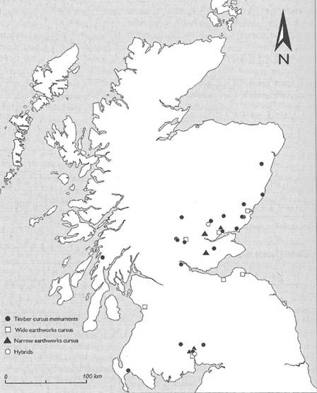
The only kind of Early Neolithic monument found in the SESARF area, other than the long mounds and related structures is the cursus. These are long, rectangular monuments constructed either of timber posts, or a bank and ditch, or a combination of the two (Brophy 2016). They may be elongated versions of Early Neolithic rectangular mortuary enclosures, for example at Inchtuthil, Perth and Kinross, and they may have been designed for ceremonial processions to commemorate the ancestors. The post-built examples, such as those around Dumfries show signs of having been burnt down deliberately, probably as part of the performance of the rituals (Thomas 2007). The huge amount of effort involved in creating these monuments indicates that they will have involved many people. This will have served to strengthen ties between communities and, perhaps, to express identity and solidarity at a scale even larger than that expressed in long barrows: perhaps at a ‘tribal’ level. Dated examples from elsewhere in Scotland indicate that cursus monuments were being constructed during the second quarter of the fourth millennium BC – with dates from Broich, Perth and Kinross, suggesting that construction continued into the third quarter of that millennium (Brophy 2016, 81–6). Two, possibly three examples, all ditch-and-bank-defined as opposed to timber-built, are known in the SESARF area (table 4.10).
| Findspot | NGR | Trove ID | Reference |
| Monktonhall (aka Inveresk, Westfield), East Lothian | NT 3505 7100 | 53692 | Hanson 2002; Brophy 2016, 51, 75, 77, 78, 124, 132, 151, 152, 153, 154, 214, 215, 219, 224, 247 |
| East Linton (west end)/ Drylawhill, East Lothian East Linton (east end), East Lothian | NT5892 7790 NT 5992 7808 | 56270, 312225 | Brophy 2016, 247 |
| Upper Whitfield, Scottish Borders | NT 17205 53339 | 374560 | Halliday 2022 |
There is a speculative cursus at Overhowden, Scottish Borders but alternative interpretations as a rectangular enclosure and as field drains are offered and it cannot be regarded as a convincing candidate.
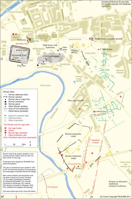
The example from Monktonhall, part of whose northern terminal was excavated during Bill Hanson’s investigation of the Roman temporary camp at Inveresk, is about 900 m long by 180 m wide, running SSW–NNE. Its NNE terminal is slightly skewed in relation to the long axis of the monument. Its sides and SSW terminal are defined by double ditches.
The example from East Linton consists of two parallel ditches, around 60 metres apart, running E–W for at least 300 metres. One probable terminal has been identified.
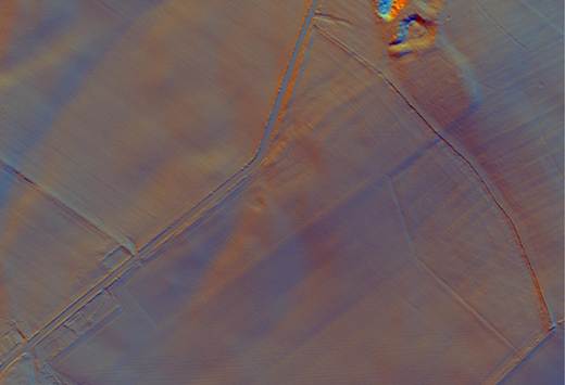
The possible cursus at Upper Whitfield has been identified with the aid of Lidar data (Halliday 2022). It appears to be at least 380 metres long by 70 metres wide. Its parallel sides consist of a low bank with external ditch and its north-east terminal is slightly askew to the main axis. The monument appears to be aligned on Black Mount, around 11 km to the south west. Excavation would be necessary to confirm whether this is indeed an Early Neolithic cursus, although obvious alternative interpretations do not readily spring to mind. The monument is not very far from the recently discovered example at Melbourne Crossroads in South Lanarkshire.
None of the SESARF-area cursus monuments have been dated, and until they have been investigated they cannot add to our understanding of the date and use of these monuments. Their location in comparison to the overall distribution of cursus monuments shows that they lie to the south of a cluster in Tayside and Fife; a second cluster is known around Dumfries.
No example of a bank barrow or similar monument type, such as a hugely elongated long mound, like that from Auchenlaich, Stirling, some 342 m long (Foster and Stevenson 2002) has been found in the SESARF study area.