This section summarises the division of land during the Iron Age in South East Scotland. Chapter 2 offers a detailed description of the region’s landscape and environment over time, including 2.8 Later Prehistory and the development of agricultural landscapes and 2.9 Roman and Medieval landscape.
Various forms of land divisions were used to divide land, possibly for stock-proofing or marking territory. Such divisions are likely to be linked economic and political structures, with the emergence of specialised delineated areas of landscape, perhaps associated with power centres within socially and economically differentiated settlement systems and potentially specialised forms of land use, mixing stock and arable (Cowley and Dickson 2007).
In the upland areas (for example, the Borders), there are linear earthworks which likely form estate or agricultural land divisions. Heriot’s Dyke and The Catrail are examples of sections of much larger boundaries which likely divided the landscape. Heriot’s Dyke is described as a low stony wall whereas The Catrail is a bank and ditch, some portions of the earthwork are noted as being referred to as ‘the Picts work ditch’ in 1861. At least one section of the Catrail has been dated to the late Iron Age (Barber 1999). It is possible that the sections do not in fact constitute an individual boundary but rather several.
On the low-lying plains of East Lothian and Berwickshire there are boundaries consisting of linear earthworks and pit-alignments. Given their proximity to Iron Age enclosures they may be broadly contemporary (see Waddington 1997; Cowley 2008; Halliday 2002)
An example of pit-alignment is around the hillforts at Chesters, Drem and Kae Heughs by Barney Mains, a few miles from Haddington (see Halliday 1982; Cowley 2009; Harding 2017). At the latter site a fort at Kae heughs, Barney Mains, survives as earthworks, while the complex remains of an enclosure system and a palisaded enclosure have been recorded as cropmarks in the field below. Much of the enclosure system is made up of closely spaced pits, arranged as a string of beads and referred to as pit-alignments; these are likely to have been supplemented by an upcast bank.
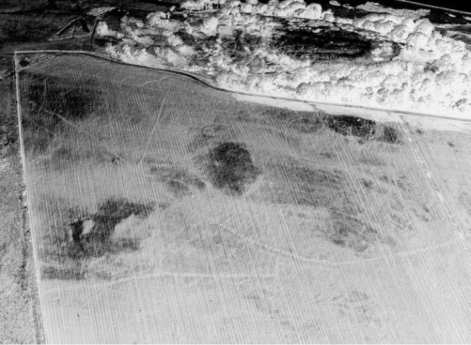
Another excellent example is Castlesteads, Midlothian where a system of single and double pit-alignments forms a network of land divisions by the lower Esk, with several ditched enclosures nearby (Halliday 1982; Harding 2017).
Not many pit-alignments have been investigated but some examples include Eskbank, Drem, Castlesteads and East Linton (Barber 1985; MacKay 1980). The excavation at Eskbank returned radiocarbon dates between the 4th century BC and the 1st century AD and the pit alignments at Castlesteads, Midlothian are argued to be Early Iron Age in date (Barber 1985; Cameron and Mitchell 2010). Work in 2018 and 2019 CFA Archaeology excavated the remains of a pit alignment outside East Linton, East Lothian. The excavation revealed an L-shaped alignment which consisted of 49 pits. A fragment of a cannel coal bangle, dated to the Iron Age, and with parallels to Broxmouth and Traprain Law was recovered from one of the pits (Hunter 2023; Savory 2023). In sum, the minimal dating of the pit-alignments and the sites with which they may have been associated suggests that this pattern of pit-alignments may have emerged by the mid-first millennium BC (Halliday 2002; Cowley 2009).
Although much is open to interpretation, there seems to be a general consensus that most of the pit alignments relate to the subdivision of a pastoral or agricultural landscape (Barber 1985; Halliday 1982; 2002; Harding 2017; Pickering 1992).