Tipping excellently details the change of coastal change in prehistory, and no further research has been undertaken in the Clyde Estuary of the past. Instead work on coastal change in Scotland more widely has targeted future coastal change and the impact on coastal heritage assets. In 2003 a Coastal Zone Assessment Survey was undertaken in the Firth of Clyde and Isle of Bute by CFA Archaeology to record and analyse evidence of coastal erosion and the potential impact upon coastal heritage sites (Cressey & Johnson 2004). The survey targeted the coastline north of the Clyde from Erskine Bridge extending outwith the assessment area to Helensburgh and the south bank of the Clyde from the east bank of the mouth of the Black and White Cart rivers to Port Glasgow, wholly within the assessment area as well as the entirety of the coastline of the Isle of Bute which is entirely outwith the assessment area. The outcome of the survey was divided into two parts, classing erosion and the impact upon heritage sites. Within the assessment the erosion classes were split into three categories: definitely eroding, both accreting/eroding and accreting/stable. The area assessed along the north and south banks of the River Clyde included 25% of the area definitely eroding, 35% accreting/eroding and 40% accreting/stable. The areas recorded as definitely eroding were located on the soft shores of the northside of the River Clyde. Fish traps and marine Crannogs were employed through this research as they are highly susceptible to change as the foundation of the sites are within mobile sediments which can be altered through tidal scour (Cressey & Johnson 2004, 186). The inner Clyde over 40% of the coastal heritage sites were recorded with poor state of preservation with recommendations for detailed survey of fish traps and crannogs to create an initial condition for further research and monitoring as well as further surveys of the shorelines to routinely monitor and class further erosion and accretion (Cressey & Johnson 2204, 187). Unfortunately, the recommendation of subsequent routine survey of the inner Clyde was not implemented as such there is no further information on the progression of erosion or accretion.
More recently SCAPE has carried out a series of surveys in the Highlands, Moray, Aberdeenshire with local volunteers to undertake rapid coastal heritage surveys (Hambly et al 2024, 240). The aim of the surveys was to update records of coastal sites with current condition and identify the most archaeologically significant and vulnerable sites identified through predictive modelling of erosion. There were a multitude of successes through this project as localised areas of greater than expected erosion was identified as well as areas which were more resilient than predicted by the models (Hambly et al 2024, 241). Utilising the community allowed for a greater area of coastline to be analysed and by extension more sites, local knowledge was used to enrich the historic record, but also a path of future assessment and management highlighted. The ease of access to coastal areas as well as the use of a mobile app for reporting information allows for local people to monitor the condition of the coast and heritage sites.
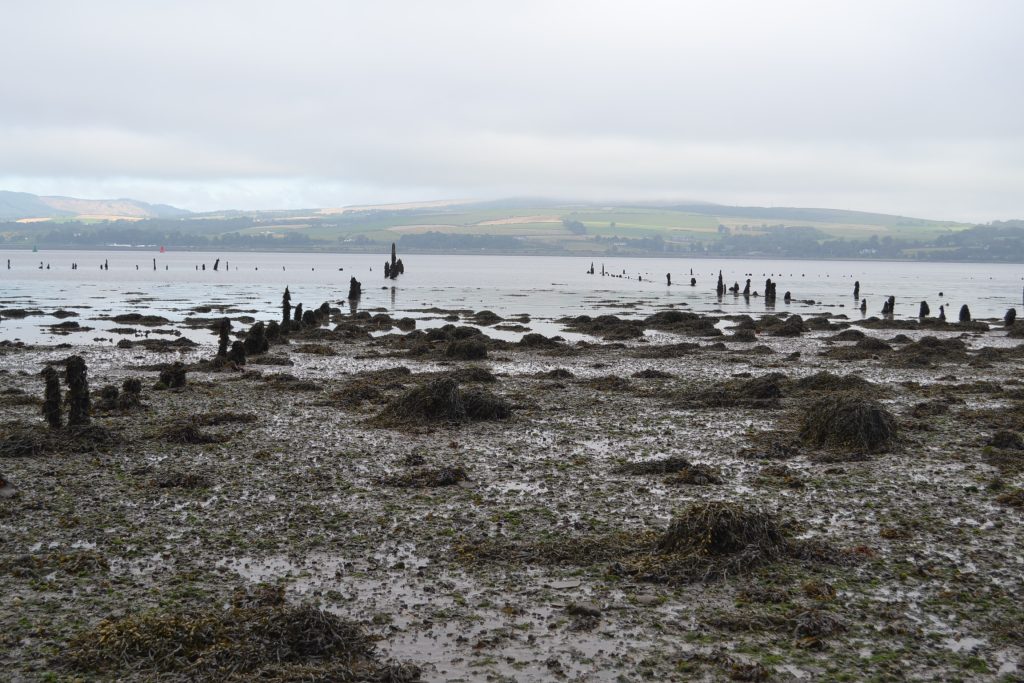
It is not only changes to the shoreline which are affected by higher water levels and stronger waves within the estuary but also impacts of the underlying sediments. Salt marshes are the morphological feature most at risk from climate change and will either be drastically depleted or washed away entirely (Karunarathna 2011, 504). The river flow cannot be predicted, modelling the long-term morphological change of the Clyde Estuary was undertaken in 2011 and concluded with five scenarios dependant on future river flow rates. The least severe was no change to current river flow rates which maintained a stable morphological state. With the most severe resulting in receding or complete removal of salt marshes and other forms of inter-tidal flats affected as well. The moderate changes of river flow create a time of instability of estuarian morphology and then return to stability (Karunarathna 2011, 506). While all but the most severe scenario result in a return to stability there is an impact on heritage sites and archaeological potential in the estuarian muds. The Old Kirkpatrick (7828), Erskine Bridge (7863) and Langbank (7901) Crannogs and Finlaystone House Timber Ponds (51577, Figure 2) all reside within estuarian muds which may be washed away, even if the period of instability is short lived. Furthermore, there is currently unknown potential for archaeological sites seen elsewhere such as the Mesolithic footprints located in estuarine muds of the Severn (Scales 2007).
This research has identified the sites at risk from projected coastal flooding in the estuarian Clyde from data available from SEPA. The heritage sites in the National Record of Historic Environment (NRHE) were intersected with the projected coastal flood layers for high probability scenario for 2080 (Appendix 1). The results showed 833 heritage sites would be impacted by the future floods in a high emissions scenario whereby little or no action is taken to avoid climate change. The projected sea level rise for the west of Scotland and River Clyde basin is 0.62m by 2080. This includes 13 scheduled monuments including Govan, carved stones and Old Parish Church graveyard (8570) and Paisley Abbey drain (12080) amongst others. The impacts of increased flooding at higher reach may also include higher force from waves but we are unable to predict future river flows. The archaeological resource within the Clyde Estuary has been discussed through this chapter as under utilised and nearly half of the sites included in the coastal zone assessment undertaken by CFA more than 20 years ago already had a poor state of survival.