The modern groundwork for the investigation of the Roman Iron Age in south east Scotland was laid principally by the Society of Antiquities of Scotland in the late 19th and early 20th century with the natural focus on the identification and exploration of Roman military sites in the region.
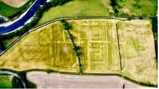
Investigations by Christison and Anderson (1901) at Lyne, near Peebles, Curle (1911) at Newstead (Trimontium), near Melrose, and Stevenson and Miller (1912) at Cappuck, near Jedburgh, uncovered substantial evidence of episodic Roman occupation. Curle’s comprehensive fieldwork and meticulous documentation at Newstead particularly stands out, setting the standard for future archaeology in the region. Further investigations at Newstead were carried out by Richmond (1952) and more recently by Jones (1990). Oakwood fort, and the adjacent campaign camp were discovered from aerial photographs in the 1940s, and the fort was excavated by Steer and Feachem (1954).
Further north, the Flavian fort of Elginhaugh on the southern outskirts of Edinburgh, was identified by aerial photography in the 1970s and was completely excavated by Hanson in 1986 — resulting in one of the most complete investigations of a turf and timber auxiliary fort anywhere in Europe (Hanson 2007).

The Antonine fort and probable supply base for the Antonine Wall at Inveresk, near Musselburgh, was first excavated by Richmond in the 1940s (1981) and the full extent of the settlement has been elucidated by multiple investigators since (Maxwell 1971; Thomas 1988; Rogers 1990; Bishop 2002 and 2004; Kirby 2020; Will and Leslie forthcoming).
The vestiges of numerous campaign camps extending northwards alongside Dere Street, from Chew Green to the Forth, have been extensively surveyed from the air over many years, notably by St Joseph (1976). These camps have been attributed to particular Roman expeditions, especially the massive camps of Channelkirk and St Leonards, which are thought to be related to the Severan incursion of AD 210/11. Until now, however, there has been relatively little ground proofing of these sites to help firmly establish sequence and chronology.
Publication of some of the excavations in the SE remain outstanding with a few key excavations (such as Newstead) remaining unpublished.
The HER records of the SE associated with Roman archaeology are dominated by temporary camps but there are significant numbers of isolated artefact finds that consist mostly of coins and also a widespread artefact scatter of small finds including fibulae, paterae, and metalwork hoards. Diverse larger artefacts, such as the Hawkshaw head, multiple paterae, and Milsington leg, appear to predominantly cluster in date to the late first and early second century. Coin hoards from the area, on the other hand, cluster towards early 3rd century suggesting these represent traces of different aspects of Roman control.
Concentrations of different data entries can be observed around sites such as Newstead and Elginhaugh and this can be attributed to the fact that these have been the focus of archaeological study and excavation whereas very few of the temporary camps have been the focus of any archaeological investigation (Jones 2011).

Since 2021, the Leverhulme-funded project ‘Beyond Walls: Reassessing Iron Age and Roman Encounters in Northern Britain’ has been carrying out research in an area stretching from about 40 km south of Hadrian’s Wall to 40 km north of the Antonine Wall (see overview in Fernández-Götz et al 2022). The project aims to examine the trends and transformations before, during, and after the period of direct Roman presence in the region, taking a long-term perspective from around 500 BC to AD 500 to evaluate transformations and continuities over time. In addition to the broad-brush picture being compiled for the general project area, four case studies are being analysed in greater depth to provide more detailed data for selected landscape transects. Of particular interest, is case study 2, which is situated along Dere Street from Otterburn (Northumberland) to Newstead (Scottish Borders), extending 57 km by 18 km (around 1,000 km²). While research is still ongoing, the project has compiled an extensive database for case study 2 and discovered numerous previously unknown indigenous sites that will improve our understanding of the Roman Iron Age in the region.