4.4.1 Holocene sea level change
This topic can appear remote to archaeologists but in Argyll and Bute it is critical, not just to early prehistorians but to later prehistorians and early historians. Shennan et al. (2006) published the first detailed reconstruction for the region, in Knapdale (Figure 18). Their approach was to identify enclosed coastal basins at different altitudes and recognise the time they received estuarine and marine sediment from diatom and pollen analyses, and the time this sediment was replaced by terrestrial sediment (peat) as sea level fell.
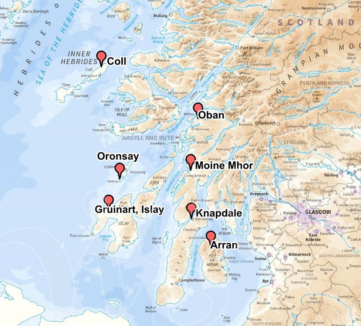
Figure 18: Map of sediment records of Holocene sea level change© Richard Tipping: Arran (Gemmell 1973); Coll (Dawson et al. 2001); Gruinart, Islay (Dawson et al. 1998); Knapdale (Shennan et al. 2006); Moine Mhor (Haggart and Sutherland 1992); Oban (Bonsall and Sutherland 1992); Oronsay (Jardine 1977, 1987).
Devensian Lateglacial sea level has been described above. Early Holocene shorelines will also have sloped because of differential uplift but we have few data points to reconstruct this gradient. Sea level is modelled to have fallen to –5m below present on Skye, to around 0m on Arisaig but to have remained above present tidal limits, around 2m above present in Knapdale (Shennan et al. 2006) but empirical evidence for this at the sites analysed by Shennan et al. (2006) is currently lacking. On Islay, Dawson, Dawson and Edwards (1998) date the lowest early Holocene RSL at around 0m OD to c. 9350 cal BC, as Dawson et al. (2001) do on northern Coll.
Dawson et al. (1998) then describe a rapid Relative Sea Level (RSL) rise on Islay to 3m OD by c. 7960 cal BC, slowing to c. 5m OD by the Neolithic period. On Oronsay, Jardine (1977) thought sea level reached c. 7m OD before this time. Sequences on the Scottish west coast currently lack the chronological precision to test the suggestion (Clarke et al. 2003) that the collapse of the Laurentide ice sheet caused a nearly instantaneous global RSL rise of around 1.4m.
In Knapdale this shoreline, the Main Postglacial Shoreline, reached c. 11m OD (Shennan et al. 2006) and c. 10m OD on Arran (Gemmell 1973). Bonsall and Sutherland (1992) suggested that coast–facing caves in the Oban area occupied prior to the Main Postglacial Shoreline would have been eroded during RSL rise, thus seeming to shorten the duration of the ‘Obanian’ flint industry.
Dawson et al. (1998) suggested that RSL levels remained high on Islay, above 4m OD until the late Iron Age, and a similar suggestion can be made for Coll (Dawson et al. 2001) and, outside the region, for Skye (Selby 2004). This differs from the interpretation of Jardine (1977) on Oronsay for a 3m fall in the late prehistoric period and by Shennan et al. (2006) in Knapdale who see RSL fall steadily c. 11m OD at c. 3500 cal BC to 3–4m OD by c. cal AD200. Smith et al. (2007) construct a 14C–dated RSL curve for south west Scotland in which RSL continues to remain high (above 8m OD) until after c. 2000 cal BC. They try to resolve the different interpretations by identifying a narrow zone in south west Scotland where the Main Postglacial Shoreline converges with a later shoreline, the Blairdrummond Shoreline (Smith, Cullingford and Firth 2000), to maintain relatively high RSL, perhaps into the early historic period. This narrow zone crosses southern Kintyre and separates Islay from northern Kintyre, explaining the contrasts apparent in these two places (above), and straddles Mull (Smith et al. 2007, Figure 8).
Reconstructing later prehistoric and early historic RSL change is thus a complex issue in Argyll and Bute, in which site–specific patterns override regional trends. Researchers should be aware of these subtleties in the use of RSL models, and the influence of local topographic settings on the expression of RSL. Radiocarbon dates anywhere in the British Isles on RSL change post–2000 cal BC are rare (Shennan and Horton 2002) but a site like Barr na Criche in Knapdale demonstrates that detailed reconstructions in this period are possible. Sutherland (1997) drew attention to the rare large coastal sediment stores of mid– and later Holocene age where ‘unpicking’ post–Neolithic RSL change would be feasible. These include the Machrihanish and Moine Mhor embayments. No work at Machrihanish is known to this author. Analyses of RSL change in the Moine Mhor (Haggart and Sutherland 1992) remain skeletal but the potential is enormous because the base of the peat falls from c. 10m OD to c. 2m OD, implying that basal peat formed at progressively later times as RSL fell. We do not know if it was possible to sail to the foot of Dunadd in the early Historic period.
There have been very few attempts in the region to depict in map form how coastal areas will have altered with RSL change, although this could greatly aid archaeological understanding of site distributions in the way exemplified in the Forth valley by Smith et al. (2010). Dawson et al. (1998) described the physical isolation of the Rhinns of Islay from the east of the island as RSL rose in the early Holocene. In the Moine Mhor, Winterbottom and O’Shea (2002) looked at the effect of a 10.0m OD RSL on Neolithic and early Bronze Age archaeological site distributions to great effect.
4.4.2 Coastline and marine changes
By this is meant change to our coastlines other than directly by sea level change. It embraces evidence for past coastal erosion and deposition and evidence for the abundances in the past of marine and littoral resources. Such evidence is fundamental to understanding the archaeology of Argyll and Bute in several ways.
Perhaps the least important aspect to this is in measuring the rate at which current coastal erosion and storm damage impact on coastal sites (Dawson 2003). The ‘soft’ dune and machair coasts of the islands are most vulnerable. There are coastal zone archaeological surveys for Coll, Tiree and Islay and Shorewatch programmes on Coll and Islay (ScAPE Trust). There are no surveys, to the authors’ knowledge, of the exposed western Kintyre coastline and the dune system around Machrihanish, or of sensitive salt marsh environments at the heads of the Kintyre fjords and the Moine Mhor.
We know very little from the region about the environmental changes at the coast or offshore. The evidence and potential are there, however. Gerard Bond pioneered such research in identifying transport from the Arctic Ocean of “armadas” of icebergs as far south as the Irish west coast periodically in the Holocene at c. 9200, 8300, 7400, 6200, 3900, 2200 cal BC and c. 600 cal AD (Bond et al. 1997). Thornalley, Elderfield and McCave (2009) analysed fluctuating surface and deep–water temperature and salinity south of Iceland. Changes in either will have affected the abundance and locations of spawning and feeding grounds for fish populations. They recognise falling salinity from the start of the Holocene to c. 6000 cal BC: the 6200 cal BC event freshened by 0.4psu the North Atlantic. Sea water was well mixed and fresh after this event for c. 1000 cal years until c. 5000 calBC. Salinity then increased to present values at c. 3000 cal BC. Rapid freshening set in after c. 2000 cal BC until this trend was reversed at c. 1400 cal BC. Particularly warm and saline conditions occurred at c. 3000 and 700 cal BC and at c. cal AD1000, probably representing persistent westerly winds at these times. Marret, Scourse and Austin (2004) have described major changes to thermal stratification in the Celtic Sea between Ireland and Wales, with strong contrasts in seasonality inferred for the period c. 4700 to c. 1650 cal BC. In the sediments of Loch Sunart, Cage and Austin (2010) define with clarity the switch from the medieval ‘warm’ period to the ‘little ice age’ at c. AD1400. Annually and seasonally resolved climate signals from marine molluscs are being explored (Stott et al. 2010; Wang, Surge and Mithen 2012).
Sand dune accumulation is a major information source. This is no longer seen to be a product of sea level change but as a product of abrupt climate change, and increased storminess in particular (Bjorck and Clemmensen 2004; Clarke and Rendell 2006; De Jong et al. 2006; Orme, Davies and Duller 2015), so here we have a measure of sea conditions that were perhaps unpredictable enough to deter crossings. Dunes on the Outer Isles (Gilbertson et al. 1999; Dawson et al. 2004), in Wester Ross (Wilson 2002) and along the north Irish coast (Wilson, McGourty and Bateman 2004) have been analysed. There is periodicity rather than continuity in dune and machair accumulation, with phases of dune building c. 4300–3800, 3200, 280–2400, 1400–1200 and 800–300 cal BC, and cal AD850 and 1400–1800. But dating by 14C is restricted to periods of climatic stability and by optically stimulated luminescence untried on the west coast compared to their deployment on the north Scottish coast (Sommerville et al. 2003, 2007; Tisdall et al. 2013).
Winterbottom and Dawson (2005) attempted to locate archaeological structures buried by drifting sand on Coll by remote sensing and ground penetrating radar, as Astin has with Mithen (Mithen pers. comm.) but the recovery of archaeological remains from dune systems will always lead to partial chronologies of dune formation. Systematic dating programmes are badly needed.
Sediment–stratigraphic and biological RSL indicators tend to describe mean sea levels, not tidal or wave extremes. Jardine (1987) mapped a series of storm–beach gravel ridges on Oronsay, thought to be of mid–Holocene age, one at least perhaps 10m above contemporary mean sea level. Smith et al. (2007) surveyed storm beach ridges probably dating to the mid–Holocene on the west and east coasts of Bute which reached up to 3m higher than contemporary mean sea level. The probable Mesolithic site of Croig (Canmore ID 233381) on Mull is protected by a large storm beach (Mithen pers. comm.) as is the Mesolithic site of Kilmore near Oban (Macklin et al. 2000). Early Holocene storm beaches are deposited from a significantly lower sea level, of course. These kinds of observation are rare: there need to be more. Systematic mapping and dating of storm beaches would provide data, though biased to Devensian Lateglacial and post–4000 cal BC events, to infer past periods of increased storminess, the degree of exposure of particular parts of the coast and the modelling of wave extremes that may have been critical to travel by sea. Innovative approaches such as Andrews et al.’s (1987a) estimation of later Mesolithic storminess from dogwhelks is to be encouraged. These authors suggest the later Mesolithic to have been less stormy than today.
There is no substantiated method other than from archaeological analysis (Barrett, Nicholson and Ceron–Cerrasco 1999) for defining the presence or size of fish populations in near–shore or deep waters (Pickard and Bonsall 2004) but such analyses are bound to reveal more about food selection than availability and abundance. The same is true of analysis of marine shells (Connock, Finlayson and Mills 1993). Sediment–stratigraphic methods need to be developed, perhaps biochemically or from quantification of fish scales (Davidson et al. 2003) to define the natural abundance of marine resources and their availability.