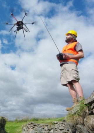
Hexakopter aerial drone and operator. Until recently, Morvern Maritime Centre surveys have been conducted with simple field equipment (plane table and tapes), with access where necessary by boat. In 2011, in conjunction with Edward Martin Photography, trials were conducted with a rotary-winged drone to obtain low-level vertical aerial photographs. These can be rectified geometrically as a basis for two-dimensional survey, allowing faster, accurate, and more detailed survey. Such survey systems are highly useful for coastal work, particularly in places of difficult access, ©Colin Martin.
For the past 15 years Morvern Maritime Centre (a charitable company with research and educational objectives) has been investigating concepts of maritime landscapes through a survey of coastal features around Mull, Morvern, Ardnamurchan, the Lorn and Lochaber mainland and adjacent islands, and Skye. The research is now being conducted in partnership with RCAHMS through its aerial photography programme. Surveys include fish-traps, harbours and landing places, prehistoric and later fortified sites with maritime associations, and coastal industries (fishing, boat-building, quarrying, mining, metal processing, gunpowder, lime production, and kelp).
Comments 1
STAC: The Severe Terrain Archaeological CampaignThe STAC (Severe Terrain Archaeological Campaign) project conducted topographic and archaeological surveys of sea stacks and other cliff-bound coastal sites around the Isle of Lewis over three annual field seasons from 2003–2005. The project made use of a specialised access system called ‘Industrial Rope Access’, which proved to be both a safe and a practical way of achieving archaeological research in such places. The first part of the report (see link below) details the formation and methods of the STAC project, and discusses some relevant geographical issues. The second part presents the results of the eleven site surveys. One of these sites, Dunasbroc, was thought to be particularly vulnerable to erosion and was subject to small-scale excavation, the results of which form the third part of the report.See the SAIR report for free: STAC: The Severe Terrain Archaeological Campaign