
Matt Ritchie
The well-preserved Neolithic rock art at Ormaig in Argyll and Bute was recorded by high resolution sub-millimetre terrestrial laser scanning in both 2007 and in 2014. The survey and recording programme was undertaken by AOC Archaeology and aimed to investigate the potential for comparison analysis between datasets collected several years apart, in order to allow stone weathering and erosion to be detected and accurately monitored over time (AOC Archaeology Group 2014).
-1024x669.jpg)
Figure 1: Recording Exposure 1 South using a Faro Platinum Arm with laser line probe under a protective canopy. High resolution sub-millimetre terrestrial laser scanning systems are typically susceptible to variable exposure conditions, with strong lighting a particular problem; during the 2014 survey a lightweight tent was used to provide shade for the scanning operations. © Forestry Commission Scotland by AOC Archaeology
Following the collection of comparable direct-measurement data, significant changes to the site were noted, largely due to moss and lichen growth over the exposures caused by the removal of the surrounding conifer plantation (which had previously provided a protective screen). The resulting exposure of the rock panels led to considerable lichen and moss growth, to the extent that some carvings were entirely covered.
This had a direct effect on the results of the laser scan survey. Very black lichens meant that it was difficult to obtain a good response from the laser during scanning, with the consequence that data voids were unavoidable. It also caused difficulties in carrying out point cloud-to-point cloud registration between the 2007 and 2014 datasets, meaning that useful surface-to-surface comparison analysis was only possible in a few key areas. Subsequent careful cleaning of the panels successfully removed much of the lichen and moss growth.

Figure 2: Exposure 1 South, geometric mesh illuminated from top left, showing the location of the surface-to-surface inspection map. Copyright: Forestry Commission Scotland by AOC Archaeology
The photogrammetric meshes, while lower resolutions, provide a valuable additional source for illustration and are comparatively easy to produce, requiring much less processing than laser scanned data. While high-resolution sub-millimetre laser scanning provides exceptional detail, the various associated logistical challenges mean that photogrammetric solutions are more practical for recording most rock-art sites. It is clear that any wider programme of rock art recording (including multiple sites in the wider landscape) should probably utilise photogrammetric recording techniques.

Figure 3: Exposure 1 South, surface-to-surface inspection map between 2007 laser scan data and 2014 data, showing some differences in cup and ring depth in the smaller cups. The ‘rosette’ carving shows some evidence of variation in the ring depth of up to 1mm. Copyright: Forestry Commission Scotland by AOC Archaeology
However, archaeological measured survey provides more than just a foundation to inform conservation management. It is a visibly impressive method of effectively demonstrating and confirming the importance of a site to land managers and visitors. The work at Ormaig highlights and confirms the significance of the site through research and communication—and this has a trickle-down effect towards the wider historic environment. Through the visible act of archaeological survey, the importance of the wider historic environment is confirmed and enhanced.

Figure 4: Exposure 1 South, detail during cleaning using a medium bristled brush. The area to the right is an example of unchecked lichen growth; the area left has been carefully cleaned. Subsequent conservation management advice was to ensure the site is strimmed on a regular basis (keeping it exposed to the air and less damp); and to brush it each year (to repress black lichen growth). Regenerating tress will also be removed. Copyright: Forestry Commission Scotland
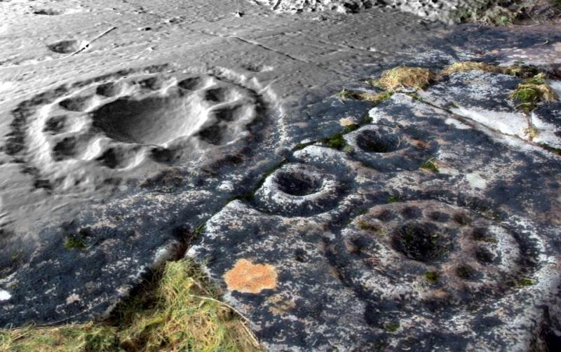
Figure 5: Exposure 1 South, oblique view of a detail from the geometric mesh. Two of the ‘rosette’ motifs are shown using simulated raking light and a juxtaposition of real colour texture (recording lichen growth) and greyscale depiction (allowing detailed observation). Copyright: Forestry Commission Scotland by AOC Archaeology
Return to 2.1 Prehistoric rock art
Return to Section 3.3: Recording
Return to Section 5.3.5: At risk categories of carved stones: other categories of carved stones
Comments 1
Pingback: 2.1 Prehistoric rock art – The Scottish Archaeological Research Framework