Understanding of the infrastructure of the early medieval economy such as the development and operation of ports and harbours, and the transportation of goods and people over land and sea is still in its infancy (SESARF 8.2.2 Demography, migration, and mobility). It has been suggested that the coastal location of Northumbrian monasteries in North East England, strongly associated with good harbours and river mouths, may indicate the presence of beach markets and riverine routes inland which could support long-distance trade links (NERF). There are numerous sand-dune sites in the study region which would be suitable in this regard. Among sites located near good harbours, Aberlady is discussed below as a productive site with numerous coins and other trade finds (SESARF 8.3.3 Coinage).


Excavated Northumbrian settlements like Dalmeny, Aberlady, Dunbar and Auldhame suggest these coastal settlements were occupied during the 8th, 9th and 10th centuries. These sites, along with the monastic remains at Coldingham, Tyninghame and St Abbs Head, suggest that much of the most high-status Northumbrian occupation (including monasteries) was at or near the coast, potentially looking for sites close to good harbouring locations, as seen at Bamburgh and Lindisfarne just outside of the study area (Petts 2009). Notable exceptions include Jedburgh, Sprouston and Old Melrose along major rivers in the Borders region.
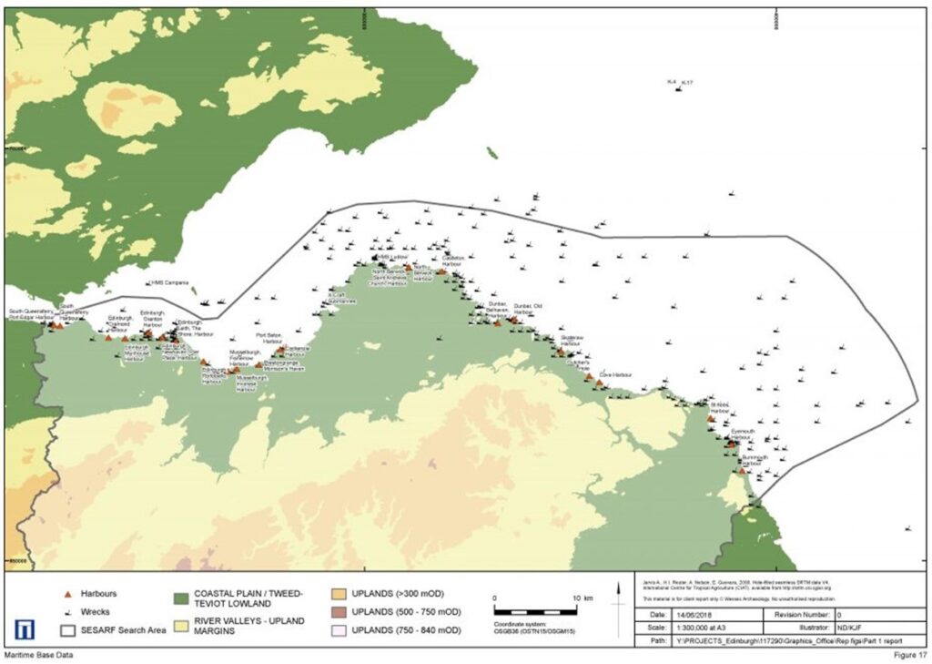
More detailed records of ports and harbours are noted from the 11th and 12th centuries. The map above shows the location of some of the harbours that are known to be from this period from across the SESARF region. South Queensferry has a long-established history as a port. There were linear rock formations on the foreshore which likely created natural landing points and these were later enhanced by the construction of piers and the early harbour (City of Edinburgh Council 2015).

During this period, it served as the south terminal of the Passagium Reginae, Queen Margaret’s Ferry, which served to give both the north and south terminals their names. Queen Margaret was wife of Mael Coluim III, king of Scotland from 1057 to 1093 AD, and she gifted the ferry crossing with ‘boats, hostels and a right of free passage for pilgrims travelling to St Andrews and Dunfermline Abbey’ (City of Edinburgh Council 2015). Since then however, the harbour has undergone extensive alterations and nothing now remains of the early medieval harbour.
Another harbour with a long-established history probably originating in the early medieval period is that of North Berwick, previously a tidal island. The island was home to the old church of St Andrew and a hospital for pilgrims, founded in the 12th century by Duncan, Earl of Fife. It is thought that the use of the harbour also dates to the 12th century as ‘ports’ at each end of the pilgrims’ ferry to Fife are mentioned in a charter of 1177 (Graham 1969).
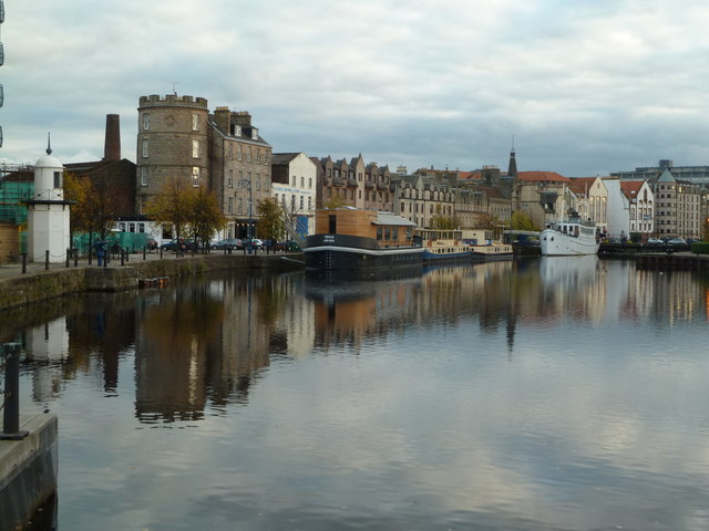
The mouth of the Water of Leith would have been an ideal landing place for craft servicing visitors and traders to the power centre of Din Eidyn from very early times, and available geoarchaeological information suggests the coastal area at Leith has changed markedly, likely building-out (prograding) seaward since the mid-Holocene (i.e. from the later Mesolithic). Leith is first recorded, or at least implied, as being a port by the charter of Holyrood Abbey in 1128 when the existing port was given to the Abbey resulting in a new harbour being established for the crown. Excavations along Sandport Street in 1997 by CECAS uncovered evidence of timber-framed buildings predating the creation of 12th century burgage plots and thought to extend back to the 10th and 11th centuries (Reed and Lawson 2000). The Shore is still a street in Leith and it is assumed that this is where early craft would have beached in the foreshore.
Within the context of coastal change a general trend that should be considered with early harbours in this period is that (if archaeological remains survive) the original sites may be inland of the current coast, and possibly buried under thicknesses of later sediments, and later urban/coastal development. For example, Aberlady and Auldhame are important early medieval sites, but what is their relationship to their contemporary (now inland) shorelines? Is there evidence for buried ports and harbours in the region?
Roads and routeways through the landscape are a perennial aspect of the human past but widespread archaeological evidence for them is partial, and difficult to date. For example, Roman routes are inferred through linear distributions of forts and temporary camps and examples of ‘roads’ appear specifically in the medieval baseline data. (For pilgrimage routes, see SESARF 8.4.5 Early monasteries). However, it is not clear to what extent there were discrete roads in use in the early medieval period. The earliest maps (all post-medieval) such as Gerardus Mercator’s map of Southern Scotland highlights the physical and political geography clearly, but with no roads. This may be partly stylistic, so as to not obscure the details of the map, or may reflect that roads and routeways are implied aspects of the cartography and presumed to exist, and not shown at the national scale.

By the mid-18th century, Roy’s 1752–55 Lowland Map quite precisely depicts the complexity of road networks, settlements, farms, areas under cultivation, uplands and upland margins and records patterns of routeways that we would assume to have developed, in some cases, from earlier centuries if not before. The complexity of how people moved around and through the landscape is a key part of understanding the SESARF region, but poorly defined archaeologically.

There is however some evidence that Roman roads remained visible and to a certain extent continued to be uses into the early medieval period. Most prominent is Dere Street, the main trunk road connecting York to Inveresk (See SESARF Roman chapter – coming soon). The name of this road is Old English, first attested in the 12th-century work of Simeon of Durham as Deorestrete, the road of Deira. A western extension connecting it to the eastern terminus of the Antonine Wall has also been identified (eg Engl and Dunbar 2016), possibly linking several of the medieval settlements identified above such as Gogar, Ratho and Newbridge.

