Roddy Regan
Introduction
Dun Mhuirich (CANMORE ID 39122) presented an intriguing multi period site, possibly originating as an Iron Age Dun from which evolved a series of enclosures and internal buildings probably of a later but unknown date. Documentary sources also told us that the site was likely connected to the MacNeil family of Taynish who have associations with this part of North Knapdale since at least the 15th century.
The first phase of excavation at Dun Mhuirich took place in June 2012 and was part of the Connected Communities: Community Archaeology in Argyll and Ulster Project whereby archaeologists from Kilmartin Museum, Queens University Belfast and Ulster University led a team of students and local volunteers.
During the second phase of excavation, which took place in 2013, archaeologists from Kilmartin Museum were assisted by over 20 volunteers and pupils from Tayvallich Primary School (as part of their All Our Stories project) and history students from Lochgilphead High School as well as the local Great Auks group. The project also initiated the Archaeological Apprenticeship scheme in which three local young people undertook a five week programme of learning basic archaeological techniques.
The results of the excavation and the accompanying research into the site are summarised below. Full reports on the excavation results can be found on the Kilmartin Museum website [http://www.kilmartin.org/docs/dunMhurichExcavation2012DSR.pdf http://www.kilmartin.org/docs/dunMhurichExcavation2013DSR.pdf (Regan 2012, Regan 2013).
Location and Topography
The site lies within North Knapdale Parish, Argyll, and is situated on the western shore of Linne Mhuirich (centred NR 7228 8441) an inlet of Loch Sween that separates this promontory of Keills from that of Taynish to the east. The B8025 road that runs between Tayvallich and Keills passes the site some 100m to the west.
The site is located on an undulating terrace that gradually slopes up from sea level at the north culminating in steep, near vertical sides at its southern end (Figure 103). The underlying geology consists of limestone bedrock with glacial till between the undulating bedrock outcrops. The vegetation cover principally consists of bracken and blackthorn scrub, with a few more mature trees growing within the site.

Figure 103: Plan of Dun Mhuirich © Kilmartin Museum
The site has long been noted by antiquarians and archaeologists and is described in the New Statistical Account ‘On a rocky mount opposite ‘Taynish’, about 160ft. above (an arm of) Loch Swein, there is an ancient fort of an oval form, with a double rampart and Various Compartments named Dun McHuiric’. The Ordnance Survey Name Book of which was compiled 1865 corrects the earlier name and states that ‘the proper name to be given to this object’ is ‘Dhù Mhuirich’, which means ‘Murdoch’s Fort’. Indeed its name seems to have evolved over time as on Roy’s map of 1746 an occupied structure or settlement is depicted as ‘Dunourich’ while an Inverneil Estate map compiled in 1789 labels the site ‘Dun vurick’ a ‘Danish Castle’.
The site was mentioned by Currie in 1830 and photographed by Erskine Beveridge in 1889 (Currie 1830). In 1904 the site was described and illustrated by Christieson and later more comprehensively surveyed by the Royal Commission on the Ancient and Historical Monuments of Scotland, this work published in their Inventory of Argyll in Volume 6 (Christieson 1904, RCAHMS 1988). The site was scheduled in 1955.
In brief the site consists of an upper enclosure measuring 15.5m by 12m with and entrance and ‘hornwork’ at the south. In the interior of the enclosure there are ruined foundations of two rectangular buildings of drystone construction, separated by a narrow passage. The smaller building measures about 8m by 4.7m with walls 0.6m in average thickness, while the larger measures about 11m by 5.3m. The remains of a third building lie in the SW of the enclosure. Outside the N gable of the largest building there are the remains of a flight of stone steps, which may originally have given access to the wall-head.
At the north and below the upper enclosure are the well preserved wall and entrance of the lower enclosure. This bifurcates at its southern end the walls protecting a series of lower shelves and terraces on the ridge. Also at this southern end there appears to be the remains of a denuded structure.
Two further lengths of drystone walling may be seen on the NW and NE of the lower enclosure the former cutting off access onto the ridge on this side and while the later wall runs down to the shore at the east where there are further walls and a series of wharves, inlets and jetties.
Below and east of the lower enclosure entrance is the remains of a rectangular structure along with a hollow that may represent a well or spring.
The Excavation Results in Brief
The Upper Enclosure (Figure 104)
The earliest deposits encountered lay within the south western part of the upper enclosure lying just above bedrock and may represent the disturbed remains of the original wall and likely associated occupation deposits that predate both the upstanding structures within the enclosure and the current enclosure wall alignment. A period of abandonment is perhaps suggested by a soil accumulation forming above the disturbed or collapsed wall. After that a large rubble deposit is deposited in this part of the enclosure, perhaps with a view to levelling the area prior to the construction of Structure 5, the walls of which lay directly over the stone dump.
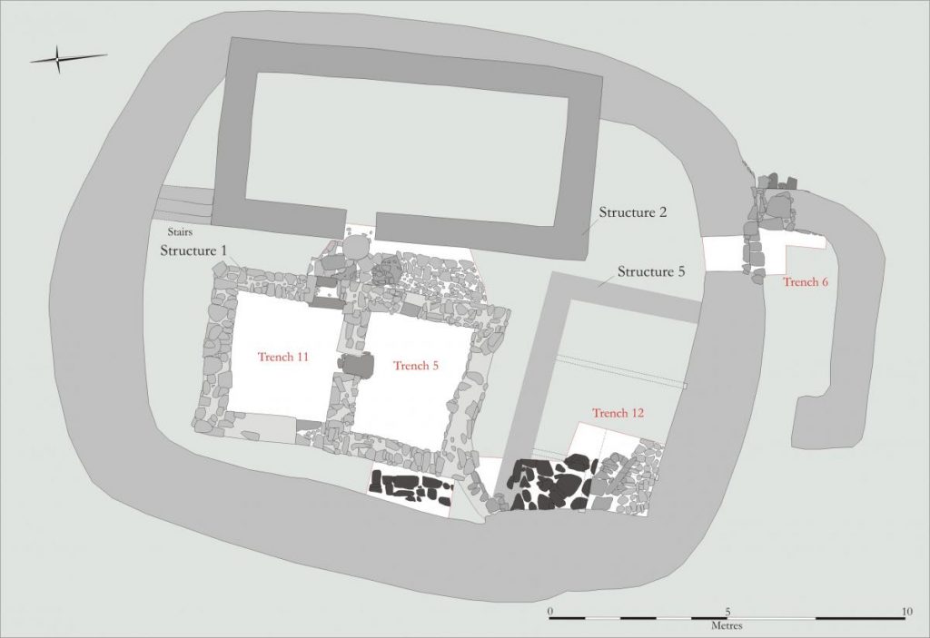
Figure 104: The Upper Enclosure © Kilmartin Museum
Structure 5 had evidence of three cruck-slots, the single cruck-slot in the W wall suggesting the building had a hipped roof. This structure had a series of earthen floors and associated burning /ash deposits. At some point the N wall of this building was demolished or realigned to incorporate the construction of Structures 1 and 2. Similar earthen floors continued to be laid within the modified building before a smaller structure, possibly a storehouse, was constructed in the SW corner prior to the abandonment and subsequent collapse of the building.
The earliest deposits within the northern part of the upper enclosure were not seen as Structure 1 had been being constructed over earlier occupation deposits which remained largely unexamined (Figure 105). The excavation also showed that Structure 1 had undergone many alterations and had been extensively rebuilt over time.
The excavation of the ‘corridor’ lying between Structures 1 and 2 revealed a well built cobbled surface with a drain running down one side (Figure 106). The drain itself appeared to be covered by a flag surface at its N end and the pottery and glass that had found their way into the drain again suggested the last occupation of the structures likely date to the mid 17th century.
The partial excavation of the entrance to the upper enclosure showed that extensive rubble collapse lay over occupation deposits.
The Lower Enclosure
Excavation within the northern part of the lower enclosure, revealed a complicated and deep stratigraphic sequence suggesting several occupation phases as evidenced within Trench 10 where natural bedrock was not encountered. The earliest deposit uncovered within this trench was a band of rubble that might represent the remains of a collapsed wall although the limited exposure of this deposit makes this far from certain. This putative wall was sealed by a series of levelling, dumps and middens that may originally have formed against the inner face of this wall. These deposits are then overlain by an early phase of the surviving enclosure wall, this in turn associated with a series of occupation deposits that included two hearth phases, suggesting structures occupying this part of the site (Figure 107).

(left) Figure 105: Early Dun? wall below Structure 1© Kilmartin Museum
(centre) Figure 106: The ‘corridor’ between Structures 1 and 2 ©Kilmartin Museum
(right) Figure 107: Hearth setting Trench 10 © Kilmartin Museum
Sealing the hearths and associated occupation deposits was a rough cobbled surface with associated post holes respecting the enclosure wall. The posts are indications of a wooden structure built against the wall and could either belong to a building or may be the supports for a platform running along the wall. The inner wall of the enclosure is then rebuilt and this rebuild may relate to the modification of the enclosure entrance. Respecting this later wall face were the last in a series of occupation deposits.
Within the lower enclosure at the south lay a badly denuded building, Structure 4, but the limited excavation here failed to produce any reliable dating evidence.
Extramural Activity
Outside the enclosure we explored a badly robbed rectangular stone building, Structure 3, confirming the size and shape of the building, although neither the associated internal floors nor the external deposits produced any readily datable artefacts.
We also investigated a suspected building lying to the N of Structure 3, Structure 6. The excavation showed that the building had stone footings, these probably overlain by a turf and stone superstructure. Two hearth positions were uncovered, belonging to the early phase of the building, indicating its use as a domestic structure, while post alignments suggested internal divisions or roof supports. At some point the building caught fire, the collapsed roofing material being particularly well preserved as carbonised remains of what on first inspection looks like heather thatch (although this needs to be confirmed by specialist analysis), which was overlain by turf, some of which had actually vitrified in the heat of the fire (Figure 108).

Figure 108: Burnt roof deposit in Structure 6 © Kilmartin Museum
The building however was not abandoned after the fire, with the walls being refaced and a new earth floor lain. Few datable artefacts were recovered from the excavated features of this building, although the one pottery sherd recovered is likely medieval.
The discovery of a canal coal bangle rough-out within a mole hill situated just above the shore and lying directly below the E end of the lower enclosure, led to the excavation of an extensive midden area as well as what may have been footings for rough steps leading up to the enclosures above. Tobacco pipe stems were recovered from the upper midden material, suggesting a post medieval date for its accumulation, although no readily datable artefacts were recovered from the lowest midden deposits.
Discussion
The excavation and survey of Dun Mhuirich has revealed a complex, well preserved site although difficult to pigeonhole into an architectural or archaeological context as few comparable sites have been excavated or dated.
The site likely originates in the Iron Age and was occupied or reoccupied in the 9th/10th century. The excavation also produced occupation evidence from the 12th to the 17th centuries, suggesting either continuous occupation or periodic use of the site between these dates. The longevity of occupation is reflected within the structural development of the site, with perhaps major reconstruction and modifications over time to the buildings and walls of the upper dun structure. The archaeological deposits within and around the structures are also well preserved, which will not only allow the understanding and interpretation of the structural sequence but, because bone survives well, will also allow the examination of diet, animal husbandry and the surrounding environment and how this may have developed from the medieval to the late medieval period. Potentially rich in artefacts and ecofacts, any future work at the site will afford a unique opportunity to understand their development and use in medieval Argyll and its cultural resonance with other sites in western Scotland, the Hebrides and Northern Ireland.
The recovery of probable Iron Age pottery along with other artefacts that may be ascribed to the period, suggest the site was occupied during this time although all the probable Iron Age artefacts came from later contexts. If occupied during the Iron Age then the site may be compared to other excavated examples including the recently excavated duns at Balure and Barnluasgan along with Druim an Duin all situated in North Knapdale.
Carbon dates obtained from bone within midden deposits from the lower enclosure indicate occupation in the 9th/10th century. This midden material may have accumulated against a now collapsed lower enclosure wall. These deposits however were not the basal occupation deposits within the lower enclosure and it remains likely that earlier deposits remain. If, as seems likely, the lower enclosure walls were constructed prior to the 9th/10th century then the site might perhaps be compared to other early historic sites such as Dunollie (CANMORE ID 23027) and Dunadd where a series of lower defensive outworks surround upper defences. The occupation of Dun Mhuirich at this period obviously asks questions to its position and status during the Viking and Norse incursions into Argyll from the 8th century and has the potential to substantially add to our scant knowledge of occupation evidence on mainland Argyll in this period.
Recovered pottery from the site indicates Dun Mhuirich was also occupied from the 12th/13th century through to the 17th/18th century, which has the potential to illuminate cultural and economic changes over this period such as more nuanced sequence of ceramic use over time in Argyll.
While perhaps not a castle in the strictest sense, by the 15th century at the latest, the site likely represents a type of house enclosure or enclosed residence as outlined by Caldwell as being present across the Lordship of the Isles in the medieval period (Caldwell 2005). As John Raven has outlined in his discussion of medieval period it can be demonstrated that many duns, brochs and crannogs in western Argyll are reoccupied in the medieval period. The most closely comparable site excavated in the region is perhaps MacEwan’s Castle (CANMORE ID 39861), a site, as the name suggests, associated with the family of the MacEwan’s of Otter. Similarly, this was a dun site with later internal structures, the recovered finds suggesting its use between the 13th and 18th century (Marshall 1979, 1982 and 1983). The excavated site of Ugdale Point in Kintyre also contains a later structure the finds suggesting an occupation in the 15th-16th century (NMRS No. NR72NE 9, Fairhurst 1956). Medieval evidence has also been found within excavations of other Dun and Fort sites in Argyll including Ardifuir (CANMORE ID 39410) (Christison 1905), Balloch Hill (CANMORE ID 38340) (Peltenburg 1982), Dun Chonallich (NMRS No. NM80SE 15), Eilean Righ 1 (CANMORE ID 22857) (Brown and Currie 1987), Kildalloig (Bigwood 1964), Kildonan (CANMORE ID 38708) (Fairhurst 1939), Dun an Fheurain (CANMORE ID 22954) (Anderson 1895, Ritchie 1974), Dun Fhinn (CANMORE ID 38467) (Bigwood 1964), Leccamore (CANMORE ID 22629) (MacNaughton, 1891, 1893) and Dun Cholla (CANMORE ID 37885) (Breen and Raven 2012). As indicated in the RCAHMS inventories for Argyll, 27 other dun sites within Lorne, Mid Argyll and Kintyre contain later buildings and it is possible many of these date to the medieval or late medieval periods. Many of these sites also have a personal or family name association which may also be a reflection of their relatively late occupation.
The status of such enclosed and defended sites has most also been outlined by Heather James in her unpublished PHD thesis, which associates such sites as being used by local middle ranking families (James 2009). The defensive nature of such sites was obviously important and a similar function might have been provided by island sites in the medieval and late medieval period such as the site on Loch Glashan (CANMORE ID 40063) (Fairhurst 1969). Several of these sites have associated traditions of being used as places of refuge by local families, such as Eilean na Crice (NMRS No. NR78NE 3) within a northern arm of Loch Sween (Coal Scotnish) which is associated with either the Campbells or MacIlvernocks of Oib. Similarly, the buildings on Loch an Daimh (NMRS No. MN81SE 2) in Craignish penninsula are associated with the MacIver Campbells of Asknish, with other island and crannog sites perhaps providing a similar function. Dun Mhuirich (CANMORE ID 39122) appears to fit this picture and appears to have been occupied by the MacNeil’s of Taynish and used as their place of residence and/or a place of temporary refuge and as such will bear cultural comparisons with medieval material recovered from more lordly sites excavated in Argyll such as Finlaggan (CANMORE ID 37708) (Caldwell 1990-1994, 1997 and 1998), Fraoch Eilean (CANMORE ID 23672) (RCAHMS 1975, Millar 1966), Breachacha (CANMORE ID 21576) (Turner and Dunbar 1970), Auchaduin (NM83NW 3, Turner 1998), Dunstaffnage (CANMORE ID 23036) (Lewis 1996, Breen et al 2010) or nearby Castle Sween (CANMORE ID 39028) (Ewart and Triscott 1996). The site might also afford the opportunity to examine the cultural aspects of the transition of landed families occupying defensible sites to more gentrified residences.
The MacNeil Connection in Brief
Prior to the 15th century we have little evidence or surviving documentation as to who may have occupied Dun Mhuirich. The name of the site has lead to speculation of an association with the MacMhuirich’s (whereby also the Curries) although while it can be demonstrated that the MacMhuirich’s had associations with Kintyre there are as yet no known extant historical records linking them with Knapdale. From the 12th century the proximity and control of the major stronghold of Castle Sween (CANMORE ID 39028) would have exerted a powerful influence over who resided nearby. The history of the castle somewhat reflects the familial and dynastic struggles that affected much of Argyll in the medieval period. The MacSween’s who likely constructed the castle in the 12th century had been replaced as the Lords of Knapdale by the Stewart Earls of Mentieth by the late 13th century using local Campbell magnates as keepers or constables of the castle.
Control of the castle would appear to have remained with the Mentieth family until Robert Stewart, as King Robert II granted the keepership to Alexander MacDonald, Lord of the Isles, who held the castle until the Lordships forfeiture in 1475. Closely associated with Castle Sween in the period of the Lordship were the MacNeil’s (of Gigha and Taynish) and it has previously been suggested that it was this family who had an association with the site and it is unclear where the Taynish branch of the family resided prior to the construction of Taynish House in the late 17th century (James 2009). The earliest origins of MacNeil’s of Taynish are somewhat obscure as no traditional pedigree survives, but as Sellar argues they are likely to have descended from the same family branch as the MacNeil’s of Barra (Sellar 1971). The family claimed the same line of descent as other prominent Cowal and Knapdale families such as the MacSweens, Lamonts and Gilchrists, their descent coming from Neil (from who they take their name) son of Muirchaidh who was a grandson of Suibhne (Sween, the builder of Castle Sween). It has not gone without notice that the name Muirchaidh (who was thought to be active in the earlier half of the 13th century (d. 1267) is not to dissimilar to ‘Mhuirich’ and it possible the later name associated with the site is a later corruption. Whether this or their claimed lineage for the MacNeil’s is true or not, it is likely that the MacNeil’s did have a foothold in the Knapdale by the early 15th century when in 1447 Torquil MacNeil became constable of Castle Sween, along with receiving the lands of Taynish and Gigha, from Alexander MacDonald, Lord of the Isles. Thereafter his sons assumed the hereditary role of constables of the castle. Neil MacNeil (of Gigha) was named as constable of Castle Sween in a charter of 1455, and his brother Hector (of Taynish) named as constable in a witness list of 1472.
As such for much of the 15th century the MacNeil’s were close adherents to the Lords of the Isles as Neil MacNeil of Gigha is named in a parliamentary summons of 1478 to John MacDonald Lord of the Isles as holding ‘Castelsone’ in rebellion against the crown. This was likely a reaction to the forfeiture of the Lord of the Isles when in 1475 the custody of the castle was given to the Earls of Argyll. The MacNeils of Gigha and Taynish seeing perhaps which way the political wind was blowing became vassals of the Earl of Argyll and by the mid 16th century the effective leadership of the family had passed to the Taynish MacNeil’s. One important document and the only one that directly associates the site with the MacNeil’s is a disposition of 1553 whereby ‘Neill McNeill McAychin of Dunworich’ (the grandson of Hector MacNeil of Taynish, constable of Castle Sween in 1472) is granted in ‘return for good service, …’the nonentries, maills, and profits of the merklands of Ardbeg and a merkland of Barbay with the mill thereof in the barony of Knapdale’. The MacNeil’s of Taynish along with the other branches of that family, including those of Arichonan and Gallachoille continued to hold and gain lands in North Knapdale. The family remained closely allied to the Campbells, the successive heads of the Taynish family marrying Campbell wives. Hector McNeil of Taynish was the Justice of the Peace for Argyll in 1629 and the family were also leading members of the church with Hector MacNeil becoming an elder of the Presbytery and in 1640 attended the Provincial Assembly of Argyll. As covenanting allies of the Campbells, the MacNeil lands in Knapdale may have been seen as legitimate targets by the royalist and MacDonald partisan Alistair MacColla who raided the area in 1647, burning nearby Castle Sween in the process. A coin recovered from the site (1642-50) dates to this civil war period and is entirely possible that during this time the site was occupied, either by MacColla’s men or locals seeking refuge in what was likely a still an easily defensible site. The site was possibly still utilised by the Taynish MacNeills until the 18th century when it is shown on Roy’s map of 1746, although by this time the family had likely moved to nearby Taynish House, likely built sometime in the late 17th century.
Dun Mhuirich Excavation Bibliography
- Anderson, J 1895a ‘Notes on the contents of a refuse-heap at the base of the fortified rock known as dun Fheurain at Gallanach, near Oban, recently excavated by Mr J. Patten MacDougall’, Proc Soc Antiq Scot, 29, 278-295.
- Bigwood, W F L 1964 ‘Dun at Glenramskill, Campbeltown’, Discovery and Excavation in Scotland, 18-19.
- Breen, C and Raven, J 2012 ‘Dun Cholla, Colonsay, Survey and Test Excavation’, Interim Report Available at < http://www.colonsay.info/text/Dun%20Cholla%202012.PDF> Accessed 20th February 2017
- Breen, C., Forsythe, W., Raven, J and Rhodes, D (2010) ‘Survey and Excavation at Dunstaffnage Castle, Argyll.’ Proceedings of the Society of Antiquaries of Scotland, 140: 165-78.
- Brown, M and Cowie, T 1987 ‘A Dun on Eilean Righ, Loch Craignish’, Glasgow Archaeological Journal, 14, 58-62.
- Caldwell, D 1990 ‘Finlaggan Medieval Residential Complex and Chapel’, Discovery and Excavation in Scotland: 31-32.
- Caldwell, D 1991 Eilean Mor, Loch Finlaggan, Islay, Discovery and Excavation in Scotland, 52.
- Caldwell, D 1992 Eilean Mor, Loch Finlaggan, Islay, Discovery and Excavation in Scotland, 55-56.
- Caldwell, D 1993 ‘Finlaggan, Medieval Residential Complex’, Discovery and Excavation in Scotland: 64-65.
- Caldwell, D 1994 ‘Eilean Mor, Loch Finlaggan, Islay’, Discovery and Excavation in Scotland, 51 – 52.
- Caldwell, D 1997 ‘The Finlaggan Project’, Discovery and Excavation in Scotland, 19.
- Caldwell, D 1998 ‘Eilean Mor, Finlaggan, Islay Chapel’, Discovery and Excavation in Scotland: 19
- Caldwell, D 2005 ‘Domestic Architecture in the Lordship of the Isles’, in R. Oram and G. Stell Lordship and Architecture in Medieval and Renaissance Scotland. Edinburgh.
- Caldwell, D. H. 1998 ‘Eilean Mor, Finlaggan’, Discovery and Excavation in Scotland, 19.
- Christison, D 1904 ‘The forts of Kilmartin, Kilmichael Glassery, and North Knapdale, Argyll’, Proceedings of the Society of Antiquaries of Scotland, 38.
- Christison, D., Anderson, J and Ross, T 1905 ‘Report on the Society’s Excavations of Forts on the Poltalloch Estate, Argyll, in 1904-5’, Proceedings of the Society of Antiquaries of Scotland, 39, 259 – 322.
- Currie, A 1830 A Description of the Antiquities and Scenery of the Parish of North Knapdale, Argyleshire, Glasgow.
- Ewart, G and Triscott, J 1996 ‘Archaeological Excavations at castle Sween, Knapdale, Argyll and Bute, 1989-90’, Proceedings of the Society of Antiquaries of Scotland, 126, 517 – 557.
- Fairhurst, A 1939 ‘The Galleried Dun at Kildonan Bay, Kintyre’, Proceedings of the Society of Antiquaries of Scotland., 83, 185 – 228
- Fairhurst, H 1956 ‘The Stack Fort on Ugadale Point, Kintyre’, Proceedings of the Society of Antiquaries of Scotland, 88, 15 – 21.
- James, H F 2009 Medieval rural settlement: A study of Mid-Argyll Scotland, Unpublished PHD thesis.
- Lewis, J 196) ‘Dunstaffnage Castle, Argyll and Bute: Excavations in the North Tower and East Range, 1987-94’, Proceedings of the Society of Antiquaries of Scotland, 126: 559 – 603.
- Marshall, D 1979 ‘The turf house, McEwen’s Castle, Kilfinan’, Vernacular Architect, 5, 1979, 33 – 5.
- Marshall, D N 1982 ‘Excavations at MacEwans’Castle, Argyll, in 1968-69’, Glasgow Arch Journal Vol 9, 131 – 142.
- Marshall, D N 1983 ‘Excavations at MacEwen’s Castle, Argyll’, Glasgow Archaeological Journal, 10, 131 – 142.
- MacNaughton, A 1891 ‘Notice of Excavations in the South Fort, Island of Luing, Argyleshire’, Proc Soc Antiq Scot, 25, 476 – 483.
- MacNaughton, A 1893 ‘Notes on further excavations of the South Fort, Luing, Argyllshire’, Proc Soc Antiq Scot, 27, 375 – 380
- Millar, H (1966) ‘The Castle of Fraoch Eilean, Loch Awe, Argyll’, Transactions of the Glasgow Archaeological Society, 15: 111 – 28.
- Peltenburg, E J 1982 ‘Excavations at Balloch Hill, Argyll’, Proceedings of the Society of Antiquaries of Scotland, 112, 142 – 214.
- Regan, R 2012 Dun Mhuirich North Knapdale, Community Excavation, Data Structure Report.
- Regan, R 2013 Dun Mhuirich North Knapdale, Excavation, Project Design II.
- Ritchie, J N G 1974 ‘Iron Age finds from Dun an Fheurain, Gallanach, Argyll’, Proc Soc Antiq Scot, 103, 100 – 12.
- RCAHMS 1988 The Royal Commission on the Ancient and Historical Monuments of Scotland. Argyll: an Inventory of the Monuments: Volume 6: Mid-Argyll and Cowal, Prehistoric and Early Historic Monuments No. 311, 189 – 190. Edinburgh.
- RCAHMS 1975 The Royal Commission on the Ancient and Historical Monuments of Scotland. Argyll: an Inventory of the Monuments: Volume 2: Lorn. Edinburgh.
- Roy, W 1747-1755 Military Survey of Scotland (original in the British Museum)
- Sellar, W D H 1971 ‘Family Origins in Cowal and Knapdale’, Scottish Studies Volume 15.
- Turner, D 1998 ‘The Bishops of Argyll and Achanduin Castle, Lismore, AD 1180 – 1343’, Proceedings of the Society of Antiquaries of Scotland, 128: 645 – 52.
- Turner, D and Dunbar, J 1970 ‘Breachacha Castle, Coll: Excavations and Field Survey, 1965-8’, Proceedings of the Society of Antiquaries of Scotland, 102: 155 – 187.
Return to Section 8.6: Recommendations for future work
Return to Section 8.3.11: Community Involvement