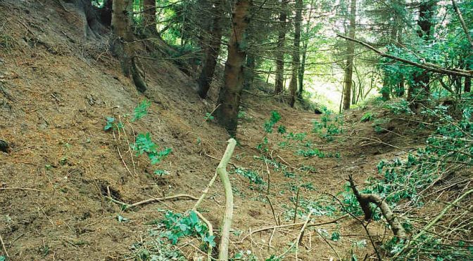
The known Roman road network in the area continues north from Stirlingshire and, with the exception of an enigmatic possible section at Reedie near Forfar, appears to end at the Woodhead (MPK3672) timber tower above Cargill where sections of the well-engineered road have been excavated (Woolliscroft and Hoffmann 2010). It is generally assumed that this forms part of one principal Roman road that essentially ran from Camelon / Watling Lodge on the Antonine Wall, through the Stirling local authority area towards Doune or Dunblane before entering Perth and Kinross and heading north to Ardoch. Crossing the River Earn around Innerpeffray, the route then takes a line along the Gask Ridge before dropping down to Bertha fort (MPK2048), just north of Perth. After crossing the River Tay the route and extent remained vague until the discovery and excavation at Woodhead. It is predicted that the road would have continued up the east side of the River Tay towards Inchtuthil fortress (MPK3639) before continuing towards Angus and the fort at Cardean (Woolliscroft and Hoffmann 2010, 158–64). In the main section, the Roman road is well engineered and includes, amongst others, a deep road cutting at Innerpeffray (MPK15365) allowing the Roman road to reach the Earn at Strageath (Woolliscroft 2004).
Archaeological work to identify sections of the road has been principally carried out by Crawford (1949) as well as Woolliscroft and Hoffmann (eg 2006). Excavations at Innerpeffray West (MPK1367) temporary camp suggested that the engineered road post-dates the marching camp and is thus likely to date to the 2nd century AD, reusing a 1st century AD track (Woolliscroft 2007). Exact dating of the road surfaces is complicated by the continued use of long stretches of the road into modern times. Historical accounts that record discoveries of Roman roads are frequently fragmented with Roman attribution suggested rather than proven. For example, Gordon (1726) refers to ‘The great Military Way…’, noting that it passes by Innerpeffray (Frere and Wilkes 1989, 3), but he assumes it is Roman purely because it is in the vicinity of the fort at Strageath. Using historical accounts that document post-medieval to modern road and bridge building offers potential for helping to address this issue. They could be employed to disentangle genuine ‘Roman roads’ from non-Roman roads as well as exploring ‘old roads’ for potential Roman origins.
Beyond the main section of road, aerial reconnaissance of the Flavian forts has identified short ‘stump roads’ leaving the gates but so far little incontrovertible evidence exists to suggest that these extended much further. In view of the frequency of these stump roads, questions remain as to how permanent or extensive road construction was. It is also unclear whether more routes existed and given the spread of fortifications which would have required supplies, more roads or at least routeways remain a possibility that requires further investigation.
With roads providing an essential corridor for the movement of military units, equipment and supplies between installations and beyond, points where the roads crossed the region’s many rivers remain an elusive yet key element requiring investigation. Roy’s map of ‘the military antiquities of the Romans in north Britain’ published in 1793 indicates a bridge (MPK2045) or crossing over the River Tay upstream of Derders Ford near the fort at Bertha (Roy 1793, Plate XII). Understanding this crossing would significantly help us to understand how Roman activity west of the river linked with that to the east and to sites further east in Angus. Similarly, there are suggestions from AD 208 and 209 dated coins for a bridge which may relate to the strategic riverside fortress at Carpow (MPK4624) and a possible bridgehead camp identified by aerial survey on the north bank near St Madoes (Reed 1976). From bridging points to consideration of the rivers and estuary as transportation routes in their own right, it is noteworthy that Carpow, Bertha (MPK2048), Strageath (MPK714), Cargill (MPK3570) and Inchtuthil (MPK3639) are all positioned along rivers which were navigable in the pre-modern period by flat bottomed craft. This raises the potential that the rivers were employed to supply major installations. The rock bars in the Tay at Stanley (now a weir) and at Campsie Linn should be considered in this discourse as they would have limited river use to downstream traffic only in these sections.