The 17th–18th centuries: early mapping and the first antiquarians
Some of the earliest descriptions of archaeological sites in the area are of the exceptionally well-preserved Roman military sites, such as Ardoch fort. While the earliest are from the 16th century, they are predominantly from the 18th century on. Fundamental to early study of the area was the establishment of the Perth Literary and Antiquarian Society in 1784, which operated until the early 20th century. Its members were particularly interested in history and antiquities, literature (especially Gaelic), natural sciences, foreign curiosities and fine arts. They compiled an archive of its antiquarian research, including an early research agenda, and a collection of mainly chance discoveries. That collection and the Society’s other endeavours formed the first iteration of what became the present-day Perth Museum and Art Gallery, where the surviving archives and collections remain (Taylor 1984; Allan 2002 and 2003).
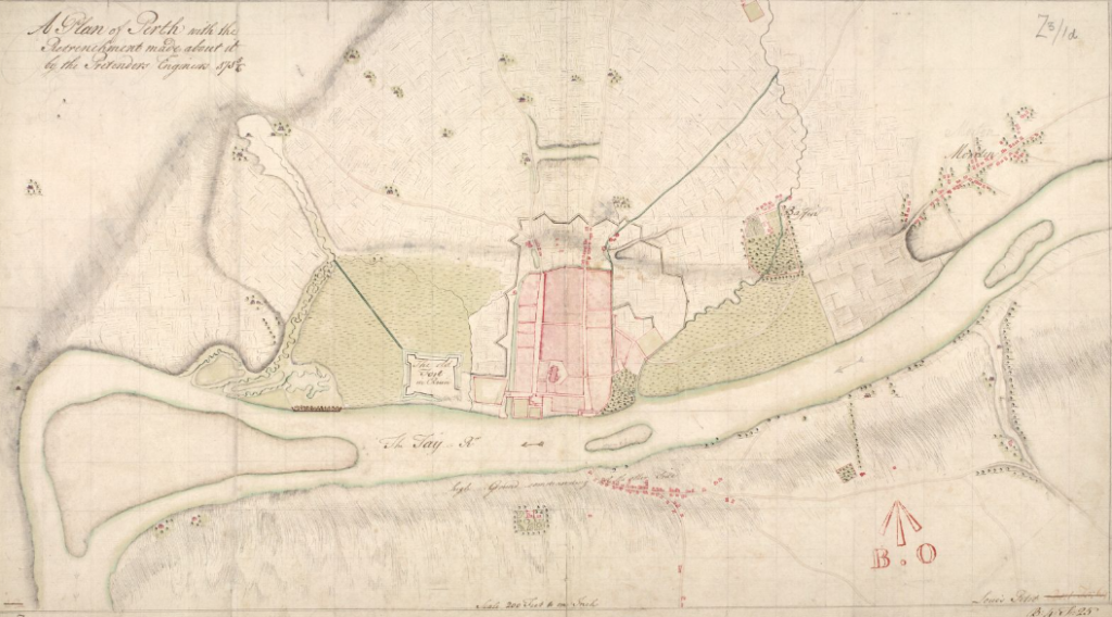
The development of increasingly accurate and detailed mapping over these centuries also played a key role in the early recording of sites, and in improving understanding of them. The surviving maps of the period are an invaluable resource today, offering insight into now-lost sites and to how sites have changed over time. The late 16th century maps by Timothy Pont are the earliest and while coverage of the area is not comprehensive, it does cover all landscape zones, while focusing on rivers, estuaries and lochs. John Slezer’s camera obscura derived ‘prospects’ published as his Theatrum Scotiae (1693) includes interesting and relatively accurate views of Perth, Scone and Dunkeld (John Slezer’s Engravings of Scotland). Soon after, the first Jacobite rebellion led to significant military mapping and provided very useful plans of Perth in about 1715–16 by Lewis Petit (Figure 3) and William Horneck. It was Major-General William Roy, as a military engineer, surveyor and antiquarian, who was uniquely qualified to contribute however. Through the use of new technology, he improved accuracy, while mapping comprehensively, in his Survey of Scotland 1747–55, and Military Antiquities of the Romans in Britain, published posthumously in 1793.
The later 18th century saw a flurry of work which provides invaluable early accounts of archaeological sites and traditions surrounding them. The Welsh naturalist and antiquary Thomas Pennant’s journeys in Scotland (1771; 1776) provide historical overviews of sites encountered. In addition to scenic views of Dunkeld and Taymouth, and plans of Roman sites, his 1772 tour included visits to several ancient ‘circular buildings’ with his local guide the Rev. John Stuart of Killin. His extensive discussion of these was an early example of landscape archaeology, and a systematic approach to enquiry, with carefully chosen local guides, that foreshadowed the Old Statistical Accounts.
The period also saw two important projects, one focusing on Perth and the other at county level. The first detailed map of Perth, by Archibald Rutherford (1774), captured the burgh much as it survived at the end of The Middle Ages, just before a period of significant expansion. Likewise, James Stobie’s map of The Counties of Perth and Clackmannan (1783) provides an important update to Roy’s systematic mapping 30 years earlier. New discovery and intensive mapping went hand in hand, as in the first record of the Cleaven Dyke, as a Roman military work between two camps on McOmie’s Plan of the Roman Wall and Camp near Mickleour (1784).
Equally significant, was the first, or Old Statistical Account (OSA), compiled by parish ministers between 1791 and 1799 and published by Sir John Sinclair of Ulbster. Irrespective of their accuracy, their accounts of ‘Antiquities’, often in notes embedded under ‘Miscellaneous observations’ or ‘Curiosities and Antiquities’, started the process of compiling lists of archaeological sites for an area. They are also important sources that capture local traditions relating to them.
The 19th century: Science and Societies
The 19th century saw a scientific resurgence with an emphasis on enquiry for enquiry’s sake. The momentum of mapping established in the 18th century continued with notable revisions of Perth plans by Robert Reid (1809 and 1818) and John Wood (1823). In addition, early reports of new finds appeared, such as that by William Jerdan of ‘Armlets found near Drummond Castle…’ in Archaeologia (1840), alongside the first detailed site histories, such as Cosmo Innes’ Liber ecclesiae de Scone (1843). In 1824, the Perth Literary and Antiquarian Society collection was made more accessible with the opening of a Rotunda Museum for both the Society and Perth Library. Modelled, in reduced form on the Pantheon in Rome, it also served as the Marshall Monument, a memorial to the late Provost Thomas Hay Marshall (Taylor 1984).
Arguably the most significant mid-19th-century developments were the publication of the New Statistical Accounts of Scotland (1845) and the Ordnance Survey (OS) first edition county series (1847–84). The former brought a more scientific approach than the Old accounts, while the detail provided by covering the entire county at 6” to the mile resulted in the discovery of many new sites. This was effectively the first comprehensive list of sites in the area. The survival of the OS Namebook for the area is also of considerable value. Amid the thriving Victorian interest in science and nature at this time, the Perthshire Society of Natural Science (PSNS) was founded in 1867. It produced a journal, in a variety of formats, from 1870 to 1991, and continues to publish a journal on an infrequent basis.
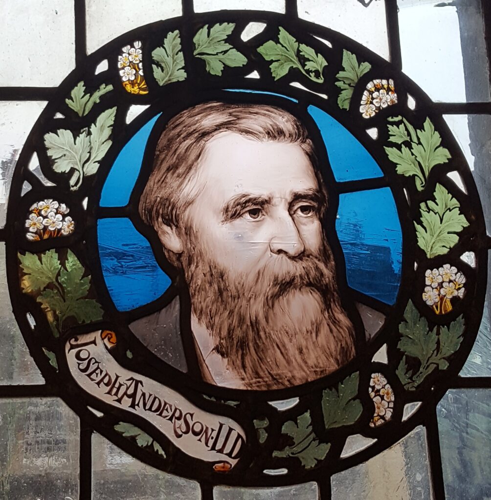
The impact of this mid-19th-century scientific resurgence is perhaps best illustrated through the Proceedings of the Society of Antiquaries of Scotland. Published over the second half of the 19th century, they show an emphasis of research on prehistory and early medieval remains in the area. In terms of prehistory, they focus on visible monuments such as standing stones (Allen 1881), cup marked stones (Hutcheson 1884; MacMillan 1884; Gow 1895; Baxter 1897) and Bronze Age mounds (Boston 1884) or sites uncovered by agriculture, such as cemeteries (Anderson 1885) and cists and urns (Stewart 1884). The importance of the area’s crannogs was also first identified (Stuart 1865; Begg 1888), while several forts were excavated (Wise 1856; Bell 1893 and Christison and Anderson 1899). The early medieval period was also well represented with papers on Pictish stones (Anderson 1877; Galloway 1877; Laing 1878), brooches (Anderson 1880), early bells (Anderson 1892; Forbes 1870), St Serfs on Loch Leven (Kerr 1881) and the coronation stone (Skene 1869). In addition, area studies were made of Aberfeldy (Hutcheson 1889), Kinross (Annan 1862) and Glen Shee (Smith 1895). Interestingly the only significant paper on the medieval period is Hutcheson’s study of Coupar Angus Abbey (Hutcheson 1888). Joseph Anderson (Figure 4), the editor of the Proceedings from 1869 to his death in 1916, also made a major contribution through his role as keeper of the National Museum of Antiquities of Scotland from 1869 to 1913 (Clarke 2002).
Significant developments were also made in the management of sites, when following previous attempts to introduce heritage protection acts, The Ancient Monuments Protection Act of 1882 recognised the need for government protection of sites. While none of the 21, predominantly prehistoric, sites on the initial Scottish schedule were within Perth and Kinross, the process of legal protection of nationally important sites, through government authority, was underway (Mynors 2006, 7–9).
1900–50: RCAHMS and the origins of synthesis
The establishment of the Royal Commission on the Ancient and Historical Monuments of Scotland (RCAHMS) in 1908 was without doubt the most important advancement in terms of recording sites. Created in response to the 1882 Act, and the wider-ranging Ancient Monuments Protection Act of 1900, it initially recorded pre-1707 buildings and monuments of note (later updated to 1805). These were published as a series of county inventories; however, the early examples included little, if any, survey in advance. Importantly for this framework, while Kinross was published with Fife and Clackmannanshire (RCAHMS 1933), Perthshire was never to see a full inventory in this style.
Research in the first half of the 20th century continued focus on prehistory, with several works of early regional synthesis. The first were F R Coles’ papers on the stone circles of north-east and south-east Perthshire (1908 and 1909), which he followed with Aberfeldy (1910) and Strathearn (1911). These were complemented by papers on standing stones (Calder 1951) and cup marked stones (Callander 1918; Dixon 1921a; Naismith 1927), including excellent work on the Strathtay examples (Dixon 1921b), and updated with discoveries by Mackey (1948). The importance of the region’s crannogs was further explored by Blundell in his pivotal paper on the Highland examples (1913, 258–65), while two other key works tackled ‘forts and camps’ (Christison 1900), and the ‘circular forts’ of ‘North Perthshire’ (Watson 1913). The latter was then updated in light of excavations at Borenich (Watson 1915).
Other notable excavations included the chambered long cairn at Kindrochat (Childe 1930 and 1931), Blairdrummond Bronze Age cairn (Callander 1929), and short cists at Meikleour (Ritchie and Dow 1935) and Abernethy (Stevenson 1948). The early 20th century also saw a resurgence in interest in Roman remains which focused on the key sites of the area. These included Inchtuthil fortress (Abercromby 1902; Anderson 1902; Ross 1902), other forts and roads (Christison 1900; Callander 1919; Richmond and MacIntyre 1936 and 1939) and the watchtowers of the Gask system (Abercromby 1904; Richmond 1940). Medieval and later periods were again less well represented (Davidson 1950; MacDonald 1921).
In 1902, the town council of Perth took over the care of the collections of the Perthshire Society for Natural Sciences, and in 1914 added to this the collections of the Perth Literary and Antiquarian Society and their Museum, which was dissolved. After many years of campaigning, the Rotunda was extended and the newly designated Perth Museum and Art Gallery was opened in 1935, giving the form seen today (Taylor 1984, 16). A new museum for Perth and Kinross is currently under development at the former Perth City Hall, set to open in 2024.
A year before the opening of Perth Museum and Art Gallery, a paper entitled ‘A New Analysis of the Early Bronze Age Beaker Pottery of Scotland’ was published by Margaret EC Mitchell (1934). Making a remarkable contribution, she would go on to have a leading role in archaeological research in the area until the 1980s, as Margaret EC Stewart (Figure 5). Pivotal to this was her influence in establishing the Archaeological and Historical Section special interest group of the Perthshire Society of Natural Science (PSNS) in 1948 and her role as its first President (Sherriff 2000, 26–7).
1950–75: Stewart, the PSNS and the local history societies
Stewart’s 30-year span of activity with the PSNS gained momentum from around 1950 (Sherriff 2000, 29). However, she also led projects with local groups such as the Abertay Historical Society and the Breadalbane Historical Society. Highlights of her excavations include Clach na Tiompan chambered long cairn (Henshall and Stewart 1954), Dalnaglar (Stewart 1962), the Lundin standing stones (Stewart 1965), her work on the ‘ring forts’ of Highland Perthshire (Stewart 1969) and Moncrieffe stone circle (1985). She also contributed through a review of Strathtay in the 2nd millennium BC (Stewart 1959), and posthumously to a review of Bronze Age burial in Tayside (Stewart and Barclay 1997). Piggott’s 1957 review of the Blair Drummond wheel, found in 1830, added greatly to our understanding of that remarkable find. 1965 saw both his excavations commence at Croft Moraig stone circle (Piggott and Simpson 1971) and the publication of the Pitnacree Neolithic round barrow (Coles and Simpson 1965).

The 1950s and 1960s also a renewed focus on Roman remains, commencing in 1952 with excavations at Inchtuthil Roman fortress, which would last 14 seasons (Pitts and Richmond 1985). This activity continued into the 1960s at the Roman forts at Carpow (Birley 1963; Wright 1964; Dore and Wilkes 1999), Ardoch (Breeze 1970) and new work at Fendoch from 1973–86 (Frere and Wilkes 1989). Much smaller in scale, but equally important, was the 1965 excavation of the watch/signal tower at Gask House by Anne Robertson, followed by work at other sites (1974).
While early medieval study continued to focus on carved stones (Calder 1951; Stevenson 1959; Henderson 1962), understanding of the period was enhanced considerably through excavation at Dundurn fort and Forteviot (Alcock et al 1989; Alcock and Alcock 1993). While the medieval period again remained rather understudied (Dagnall 1958; Stevenson and Henshall 1957; Laing 1971), medieval Perth was soon to be placed at the forefront of archaeological research in the area due to the nascent development of the High Street. It is significant that this period also saw a healthy broadening of interests into the post-medieval period with papers on cruck framed buildings (Dunbar 1957), Caulfeild’s military roads (Graham 1964) and iron bloomeries around Loch Rannoch (Aitken 1970).
1975–90: Rescue!
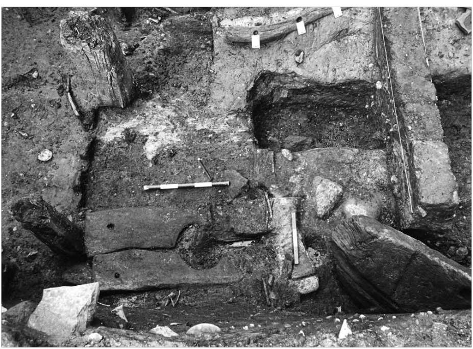
Before development management archaeology was introduced through National Planning Policy Guideline 5, there was no systematic check for the impact of new development on archaeological remains. As a result, local communities often resorted to protest in order to persuade developers to allow museum staff, university archaeologists and volunteers carry out ‘rescue’ work in advance of destruction. Again, Perth and Kinross was fortunate in having Margaret Stewart, who in 1974 formed the Perth Archaeological Survey in response to the threat of development to urban archaeology (Sherriff 2000, 35). Monitoring of development led to small-scale excavation in St Ann’s Lane (Thoms 1983), and ultimately the Scottish Development Department (SDD) funded excavations led by Nick Bogdan at 75 High Street (now Marks and Spencer) between 1975–77 (Figure 6). One of the largest urban medieval excavations carried out in Scotland, they remain unparalleled in terms of the depth, quality and quantity of deposits uncovered. Due to the waterlogged soils, a remarkable range of 29 timber buildings and rare organic small finds such as leather and textiles were recovered, and eventually published, in four fascicules between 2010–12.
In 1977, the SDD’s Ancient Monuments Directorate (which later became Historic Scotland) and the Society of Antiquaries of Scotland together founded the Urban Archaeology Unit. In 1982 this became The Scottish Urban Archaeological Trust (SUAT), based in Perth due to the amount of work being carried out in the burgh. SUAT’s urban expertise was much tested over the 1980s and 1990s, often funded through the Manpower Services Commission and the SDD, the results of which have been collated (Bowler 2004). After this, their remit broadened to more fully embrace developer-funded projects and research projects.
Developer-led, and funded, archaeology began in the 1970s as the first local government archaeologists brought specialist advice to local planning authorities. The aim was to manage development and mitigate the impact of new construction, following widespread unrecorded destruction during the 1960s. English local authorities had comprehensively secured this advice by the early 1980s along with the Sites and Monuments Records (SMRs), the key information base that underpinned the advice (Baker 1999). Local government in Scotland took longer to react, however. Partly in response to the variability in local authority services, the Tayside and Fife Archaeological Committee (TAFAC) formed in 1977 as a liaison group to promote and protect archaeology in Perth and Kinross, Angus, Dundee and Fife.
Forestry was another major issue of this period. In the 1960s, Scotland’s forest and woodland cover was around 6% and a drive for afforestation, initiated by the Forestry Commission, was followed in the 1970s and 1980s by private forestry schemes that saw tax liabilities diverted into woodland creation. A general lack of consultation and regulation saw large areas of the uplands ploughed and planted, and led to clashes with both nature conservation interests and the heritage sector. In response, the RCAHMS established the Afforestable Land Survey in 1989 to undertake strategic survey in areas where new planting was likely. The programme was the subject of consultation and agreement each year between the RCAHMS and Historic Scotland with the advice of the Forestry Commission. By the 1990s, the nascent commercial archaeological sector was beginning to provide walkover surveys in advance of planting, and local government archaeologists began to advise on forest plans.
Several significant research excavations also began in the late 1970s, including at North Mains burial mound and henge (Barclay 1983), Dundurn fort (Alcock et al 1989). Oakbank crannog on Loch Tay (Dixon and Andrian forthcoming), revealed organic remains from the Iron Age which were on a par with those from Perth High Street. Professional excavation in advance of development became more common outside the burgh from the 1980s (Barclay 1983; Watkins 1981; Hingley et al 1997). In addition, pre-afforestation excavation of hut-circles at Carn Dubh, Moulin, from 1987, significantly revealed early medieval use (Rideout 1995). Other major excavations included the Bronze Age cairn at Sketewan, Strathtay (Mercer and Midgely 1997) and the kerb cairn at Beech Hill, Coupar Angus (Stevenson 1995).
Another major source of new discoveries over this period was through the establishment of a programme of annual aerial survey by RCAHMS in 1976, building on the pioneering work by J K St Joseph of Cambridge University. The initial focus of this work was primarily on discovery and recording of cropmark sites but soon expanded to record known archaeological sites, monuments and historic buildings. The discovery of considerable numbers of cropmark sites has significantly changed our understanding of many periods. While aerial survey enhanced the national record of historic buildings, beyond standing building surveys of listed buildings, post-medieval archaeological survey remained somewhat fringe. A notable exception was a study of 18th-century and later roads and bridges from Dunkeld to Inverness (Curtis 1979).