From c 12000 BC to c 4000 BC, significant changes in landscape and environment took place. The broader history of environmental change and specific crisis points have been covered by several authors, most notably by Tipping et al (2012; 2017) in various papers relating to National ScARF and RARFA in particular. Some of these multi-period trends are discussed in Chapter 3.2. There is a need for further multi-proxy studies, drawing upon targeted locational evidence which can take account of site-specific idiosyncrasies.
The development of the coastal topography and landscape of Scotland is particularly complex, with much variation even across relatively short distances. At this point it is important to note the influence of local topography on relative sea-level change; broadscale models, such as those which seek to provide an idea of the changing relative sea-levels around the shores of the North Sea, are not suitable for an analysis of the impact of this change on individual human communities. For that it is necessary to undertake specific research targeted at particular lengths of coastline. In addition, while relative sea-level change is not, generally, an overnight disaster in human terms, the potential significance of individual events, such as the Storegga tsunami of 6200 BC, should not be forgotten. The effects of the tsunami can be seen at various coastal locations in Scotland including Inverness (Palaeolithic and Mesolithic section 3.4.2; Dawson et al 1990; Smith 2019); for coastal communities events like this would have been catastrophic (see Edwards 2004b, 67).
The coverage of the last Scottish ice sheet provides a useful tabula rasa from which to start and, though precise details are lacking, the initial warming of the north Atlantic area is generally taken to have begun around 12700 BC. It should be noted here that recent models push initial deglaciation of the last British Ice sheet to around 25000 BC (Shennan et al 2018). This early warming, together with favourable precipitation, encouraged the development of biological productivity seen in organic soils and vegetation, and – importantly – the sea (Schmitt 2018). In many parts of Scotland at the end of the Lateglacial, shorelines were higher than today despite the fact that the absolute sea-level was around 120m lower. This is due to the impact of isostatic recovery which means that the land, freed from the weight of ice upon it, had since risen faster than the rising sea-levels around it (Dawson 2018; Wickham-Jones 2018).
At this point in time, Britain was still attached to the continent by the landscape of Doggerland. This meant that people who wished to explore the northern landscape as it opened up from under the weight of ice could travel on foot, or along the coastal seaways (Ballin and Wickham-Jones 2017). It is worth noting, however, that research suggests that those who occupied the northwestern expanses of Europe at this time were more at home among a gentler, lower topography of plains and valleys. The emerging upland landscape of the Highlands would not only have provided scope for exploration, but also have taken people out of their comfort zone.
These favourable conditions were not to last; the onset of the Younger Dryas, around 10900 BC, which took place over a few decades included a sharp decline in temperature and a return to glacial ice cover in specific areas such as the Grampians, Cairngorms and the vicinity of Loch Lomond. While the presence of ice does not mean that we should rule out human activity, it would certainly have made life more difficult, and survival required adaption and flexibility. The current lack, though not absence, of well-dated evidence for human activity in much of Britain during the height of the Younger Dryas is telling. Perhaps it was the scale and speed of the environmental decline at this time, rather than the ability of the early community to survive harsh conditions, that mitigated against human occupation.
Around 9700 BC rapid amelioration of the environment occurred, and the Younger Dryas gave way to the period known as the Holocene. Despite a period of relative improvement (albeit with cooler oscillations for example around 9400 BC, 8350 BC, 7550 BC, and 7350 BC), a marked deterioration has been recorded around 6200 BC, known as the 8.2ka BP Event (Tipping et al 2012). Within a few years, temperatures and rainfall both decreased, and windiness increased. These poor conditions may have lasted for up to 400 years. Wicks and Mithen (2014) have recently examined this event by assessing both the environmental impact and possible knock-on impact on the human population. They note a disturbance to vegetation, including the loss of woodlands, as well as an increase in sand blows and dune formation. The event is associated with a weakening of the thermohaline circulation in the North Atlantic, including the Gulf Stream. This is important because it means that those who lived in the Highlands at the time would have been compromised on two fronts: terrestrial and marine.
In this period of deterioration did communities fail, or did everyone move away? Wicks and Mithen (2014) favour a scenario of population collapse due to falling birth rates and increased mortality as a result of the harsh conditions. They also suggest that, in the face of such abrupt change, low population density may well have reduced the inherent lifestyle flexibility. While there is too little evidence to identify a single scenario, it is still important to ask questions about population size. It is worth noting that recent research in Greenland and Iceland suggests that where population density is already low there are some circumstances where environmental stress will not always lead to further noticeable diminishment (Kevin Edwards pers comm, but see also Dugmore et al 2007). Targeted research could be constructed to examine individual elements (possible locations for displaced communities, potential evidence for mortality) of this question within the Highlands.
Information relating to the periods of stasis in between these crises is still missing from the archaeological record. It is also important to remember that, while large scale landscape and temporal models are useful, if dealing with individual human communities, then we need the specific data relating to their situations both geographically and chronologically.
In contrast to the tsunami, which is likely to have resulted in considerable distress and loss of life, the drowning of Doggerland took place over many centuries and is likely to have been much less of a threat to low density coastal populations with inbuilt flexibility of lifestyle (Weninger et al 2008; Wickham-Jones 2020c). It is also worth noting that current models suggest that the coastline of Doggerland lay many miles to the south of the current Highland region by the Early Holocene, further reducing the likely impact of the loss of this land surface on the early population of the Highlands (Boyd, pers com), though other studies suggest otherwise (Waddington 2015).
The transition from glacial landscape to the recolonisation of the landscape with plants and trees may have been swift, but it was not uniform. It is still only patchily understood for the Highland area, although there is an increasing amount of data (Tipping 2004, 46; Kelley et al 2017). For example, sampling on Skye has shown that tephra dating to c. 10257–10056 cal BP (c 8300–8100 BC), predates the arrival of hazel. At Glen Spean, Lochaber the area must have been deglaciated by 10,830 ± 37 cal BP (c 10876–10780 BC; Kelley et al 2017, 130–2).
In the past environmental reconstruction has relied heavily on palynology (the evidence of ancient pollen grains). However, a range of other data is now recognised (see Chapter 3.2), and more multi-proxy studies are needed. In general, birch and hazel were well established across most of Scotland at the start of the Mesolithic, with elm, oak, and pine colonising later (Tipping 1994; 2004; Bishop et al 2015). Some studies suggest that tree cover may have occurred later in parts of the Highlands, for example, at Loch of Winless and Aukhorn in Caithness (Peglar 1979); Robinson 1987); Tipping 1994, 17).
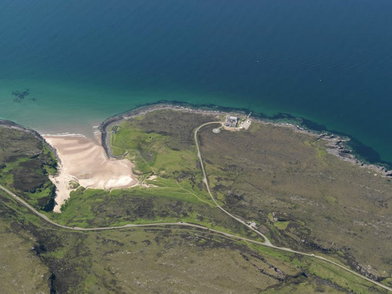
Information on the interaction of the human population with plants and woodland in the Highlands is rare (but see Bishop et al 2015) which focussed on three sites in the Highlands), though pollen information, and in some cases macrofossil data, is available from a number of sites showing Mesolithic activity. In a few cases this data has been combined with wider core sampling, including from Oliclett in Caithness (MHG29867; Tipping et al 2007a; Tipping 2008 2105–7) where peat formed over a Mesolithic lithic scatter, and at two sites on Skye: Camus Daraich (Cressey 2004a) and An Corran (Green and Edwards 2009; Case Study An Corran). Despite the numerous techniques employed at Oliclett, however, it was still not possible to determine whether peat formation was influenced in any way by human activity (Tipping 2008, 2100).
The information from An Corran (MHG35899; Case Study An Corran) is a salutary example of how localised archaeological information can be. Three coring sites were chosen near to An Corran. Evidence from the cores showed a transition in lake sediments from minerogenic silts and clays to more organic material at the beginning of Mesolithic. This indicates there was a typical pollen succession of grasses, crowberry, juniper, birch and hazel-type plants but with variations between sites. Typically, birch and hazel dominated (Green and Edwards 2009).
Identification of woodland management in the past has been found through analysis of large samples or by identifying palynological changes thought to be indicative of disturbance. It has been suggested that the sharp rise in hazel pollen in the Mesolithic reflected woodland manipulation. However, recent thinking suggests that this is more likely to derive from climatic factors (Tipping 1994, 9; Bishop et al 2015). Human intervention is difficult to determine (see Chapter 3.2). It is generally believed that Mesolithic hunter-gatherers managed their resources to some degree through systematically exploiting wild plants or managing woodlands for food and fuel (Bishop et al 2015). However, data to assess this remains sparse in the Highlands.
Evidence of burning is found at a number of sites, for example in the Flow Country, Caithness (Robinson 1987); Charman 1994) and on Skye (Green and Edwards 2009). In some cases, this has been attributed to human activity, though whether deliberate or not remains open to question. At Kinloch, Rùm, (Case Study Kinloch Rùm) a sudden decline in alder and hazel combined with an increase in charcoal and grasses in the late Mesolithic was interpreted as human clearance (Hirons and Edwards, 1990), but this was not necessarily a single event, given the lack of dating precision (Bishop et al 2015, 68).
There are, nevertheless, hints that Mesolithic communities selectively used native woodlands. Analysis of data from sites throughout Scotland concluded:
‘Overall, the present data suggest that birch, elm and alder were avoided for burning as fuels to some extent. Considering the good burning qualities of hazel, oak and ash, the prevalence of hazel and oak and the rarity of ash charcoal can be attributed to the relative abundance of hazel and oak and the scarcity of ash in the environment. Thus, current evidence suggests that species availability had a strong influence on the choice of fuels exploited by Mesolithic people, but that species with poor combustion qualities were deliberately avoided in favour of species with good burning properties’ (Bishop et al 2015, 66).
More detailed work on Highland sites is needed to see if the evidence supports this across the region.
The excavations at Sand, Wester Ross (Case Study Sand), included good environmental analyses, particularly relating to the substantial quantity of wood charcoal. Most Mesolithic sites from north-western Scotland focus on pollen. At Sand, however, information from pollen was less useful. Charcoal evidence showed the familiar birch and hazel dominance, but also included heather, apple and small quantities of alder, ivy, holly, honeysuckle, pine and cherry; oak and elm were lacking. The motives for choosing the different woods are impossible to determine, but the interpretation the excavators favoured was the opportunistic foraging of deadwood. Many species were good for burning, but some such as ivy, honeysuckle and heather were poor. These species were perhaps used for kindling, were the waste from woodworking or other manufacture or were even just an accidental by-catch (Austin 2009).
| Site | Sources |
| Oliclett, Caithness | MHG29867; Tipping et al 2007a; Tipping 2008, 2105–2107 |
| An Corran, Skye | MHG6497; Green and Edwards 2009; Saville et al 2012; Case Study An Corran |
| Camas Daraich, Skye | MHG29196; Cressey 2004a; 2004b; Wickham-Jones and Hardy 2004 |
| Kinloch, Rùm | MHG3987; Hirons and Edwards 1990; Wickham-Jones 1990; Case Study Kinloch Rùm |
| Sand, Wester Ross | MHG35892; Hardy and Wickham-Jones 2009; Austin 2009; Green and Edwards 2009; Case Study Sand |