‘Archaeologists, in the main, study settlement: palaeoecologists and environmental archaeologists usually study land use.’ (Tipping et al 2012, 16).
Human activity was both affected by environmental factors and caused environmental impacts. For example, iron smelting and smithing would have produced pollution, impacting on the surrounding environment and this evidence is perhaps available in chemical signatures (see Mighall et al 2017). It would also have had an impact on the health of those working or living nearby. The use of large timbers in buildings would have in some cases necessitated timber management; evidence for timber use can be found in charcoal analysis and combined with pollen data to assess the need for management. Demand for certain fuel types influenced landscape utilisation and management, which in turn affected biodiversity.
Settlement evidence for the Highlands is not uniform. Gaps exist in some periods, especially along the Great Glen and in Badenoch and Strathspey. It is likely that both areas were settled from an early date, and the Great Glen was surely a transport route then as now. Both areas, however, have seen significant forestry, with constant planting and re-felling from at least the 18th century. This practice, together with ploughing in the lowland areas, has limited the evidence base. Local surveys drawing on mapping and documentation may identify likely contenders for future work where the destruction may be less comprehensive.
The Highland topography and soils clearly affected archaeological site selection. Alluvial fans allowed soil nutrients to be replenished by river flooding that redeposited sediment. But such flooding frequency and intensity was affected by climate change, which in turn would have had an impact on farming. Well preserved sites on alluvial fans such as Suisgill, Sutherland (MHG9345; Barclay 1985), suggest that development such as road or pipeline construction which crosscuts the fan in particular merit investigation.
Human activity in turn influenced the soils, including use and reuse of peat and turf for construction and manuring. The legacy of extensive stripping is also under-recognised. The use of some geoarchaeology techniques in the Highlands can shed light on human impacts on soils (ScARF Science section 4.2), though it is worth noting that as of yet relatively little work has been undertaken in the Highlands (see 3.4). The SASSA website offers support and training for curators and field archaeologists on the application of soil science techniques to archaeological questions, providing a useful option for collaboration.
The issue of when uplands were first colonised has been explored in some studies, for example Lairg (McCullagh and Tipping 1998), the Garbh Allt catchment area near Rogart (Tipping et al 2008b) and Glen Affric (Davies et al 2004). Little settlement evidence survives from the Neolithic period (Chapter 5.3), but pollen evidence may help fill the gaps and indeed help target areas for this evidence. Can archaeologists shed light on lowland-upland contrasts in agriculture and settlement through the ages, linking to evidence of climate changes? The information about the introduction of agriculture in different areas and times throughout Highland needs to be gathered and the gaps then targeted.
What building materials were used would have been dependent on the local environment and cultural preferences. Available local woodland resources can be identified through environmental analyses (see 3.2.2). Turf was certainly widespread until modern times, but it is difficult to identify in the record. The fact that archaeologists sometimes find older finds over more recent construction details can be explained by people using turf blocks cut from earlier deposits, as at Seafield West near Inverness. Scientific analysis can be used to identify turf and needs to be more widespread when looking for settlement in rural areas (Romankiewicz 2019, 138–39). There is also potential to use thin-section work and phytolith analysis on floor samples to identify turf use in construction.
Experimental construction of structures as has been occurring for example, at the Highland Folk Museum (Noble 1983; 2003) and in projects by John Barber (2017) has much to offer, from information on practical limits to insights into local ecology and management.
The lifespan of these buildings needs further investigation. These investigations depend on fine tuning the dating to generational levels and require multiple dates from within structures. When a building was considered unrepairable, did people then build nearby (as can be demonstrated in crofting landscapes from the Modern period), or did they shift further afield, and how would archaeologists be able to demonstrate this? For example, evidence of fungal hyphae in charcoal fragments might suggest rot had set in at a certain date. Issues of resource demand and availability can also be explored where documentary evidence exists.
Field systems also need a landscape approach and benefit from good environmental sampling. They are elusive in most periods: numerous linear banks or dykes are known, but no convincing full enclosures or arrangements of enclosures (as in co-axial field system) of prehistoric date have been identified. Is this because physically enclosed parcels of land were not used or because the enclosures were completed with organic materials? Cairns and dykes in the landscape are often ignored; this is a problem for Scotland as a whole, not just the Highlands (ScARF Bronze Age sections 3.1, 3.4). There was some attention to this at Lairg. Indeed such large dykes running parallel to the contours but in the vicinity of round-houses proved to be the most reliable source of deep, undisturbed stratigraphy and thus of good information on land use and, surprisingly, human burial (McCullagh and Tipping 1998).
These ubiquitous monuments are perhaps Highland’s real treasure house of information for all periods up to the clearances. If wattle fencing was used, this would probably leave little evidence in the archaeological record. At Newton on Islay, however, extensive Neolithic fence lines were very obvious in an open area excavation (McCullagh 1989), showing that evidence may survive in some cases. A Young Archaeologists Club project investigated dykes near Dingwall in Easter Ross. The main dyke was primarily of turf, with clay laid the bottom. Only one radiocarbon date was obtained, yielding an Iron Age date, but this provided only a terminus post quem date as the burnt turf could have been redeposited (MHG58319; Lachlan McKeggie 2017). Optically stimulated luminescence techniques hold out potential for dating field systems even in multi-phased sites (ScARF Science section 1.4; Vervust et al 2020).
Multi-period Settlement Landscapes
A number of multi-period dune sites occur in the Highlands with a wealth of artefactual material. For example, see Culbin Sands near Nairn spanning the eastern border with the Highlands; Littleferry, Sutherland (MHG11663; Bradley et al 2017; Case Study Littleferry Links); Fendom Sands, Easter Ross (MHG60225); and Cul na Croise MHG356) and Sanna Bay (MHG14370), Lochaber. Other potentially similar sites need further investigation, including Cuthill Links, Sutherland (MHG11824; MHG17927; MHG18108); Achnahaird Sands, Wester Ross (MHG9129); South Cuidrach, Skye (MHG59071), and Loch Sunart, Lochaber (MHG148). There are also a number of recorded shell middens which might be single or multi-period, on both a small or large scale; some are also in dune areas. Some show very long intermittent use; the two Palaeolithic sites on Skye (MHG59071; MHG7704) have lithic material over thousands of years.
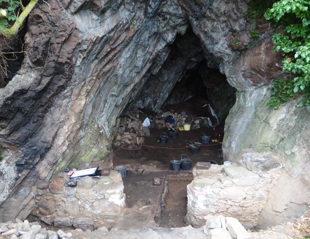
Rock shelters and caves on both the east and west coasts of the Highlands also show multi-period use. The Rosemarkie Caves project is providing detailed analysis and dating, but due to sea levels these sites are unlikely to have Bronze Age or earlier occupation (Steven Birch pers comm; Case Study Rosemarkie Caves Project). The Scotland’s First Settlers Project identified a number of cave sites in Wester Ross and Skye, with selected test pitting for dating and excavation in a few cases (Hardy and Wickham-Jones 2009; Case Study Scotland’s First Settlers Project). These sites often have good preservation and warrant further investigation, with attention being paid to beach sites.

Further work at these coastal sites assessing sea level changes and the local environment would be useful. Environmental evidence will help to assess the landscape changes and dating to determine if they were used seasonally or throughout the year.
Similarly, crannogs represent a long-lived settlement type. The Highlands lack any evidence thus far for Neolithic or Bronze Age use, but this may be down to lack of investigation and dating. The Iron Age was undoubtedly a major time for settlement on islands (see Chapter 7.3), but there is later reuse and in some cases new crannogs were built in the medieval and post-medieval periods. These sites hold great promise of good preservation.

Other potential long-lived multi-period sites are shielings, upland sites used in the summer for cattle grazing while the lowland farms were cultivated. Small structures of turf, stone or a combination of materials were built in locations with grazing and some cultivation nearby. The practice in the Highlands dates back to medieval times at least. Identification depends in part on location, placename evidence incorporating Gaelic Àirigh or English Shiel, and analogies to the few excavated examples (Foster 2017; Dixon 2018). Large numbers have been identified in surveys, often in clusters, and the Highland HER has hundreds of references. For example, over 300 shielings were located in a variety of upland locations during the comprehensive survey of Strathconon undertaken by NoSAS. These structures had a variety of construction methods, from dished grassy mounds to roughly constructed rectangular stone structures, and some had a number of special features such as outshots (Marshall 2011b). NoSAS also partially excavated two shielings in Glen Feshie, Badenoch and Strathspey (Marshall 2013a; Case Study Glen Feshie Survey and Shieling Excavation). However, few Highland shielings have been investigated and even fewer dated. Other excavated examples include Torrin on Skye (MHG5158) and Allt Mòraig, Inverness-shire (MacIver and Williamson 2016).
Shielings remain very much understudied in the Highlands (but see Miller 1967; Love 1981; Bil 1997; Davies 2016; Randall 2017 and Dixon 2018 for studies elsewhere in Scotland). The Highland Folk Museum, Badenoch has created two reconstructions based on Highland remains. The Shieling Project in Inverness-shire is exploring shieling life in a family-oriented educational project. Dating is crucial as the situation was not static, and sites would have evolved due to outside factors such as new access to markets, droving or conversion of estates to sheep farms in the 18th and 19th centuries (Dixon 2018).

Only with well-dated examples will we be able to address issues of construction, form and use over time. Do the clusters represent contemporary occupation by different families or chronological use, or both? Almost no environmental sampling has been done at these sites (see eg Aitken 2016), but elsewhere shows potential to shed more light on these structures and their uses, and perhaps regional differences (Davies 2016). The issue of seasonal versus full time occupation remains to be explored more fully, and will require multi-proxy environmental studies (see eg James 2009; Davies 2016). Gaelic sources also address shieling life.
For each of the periods discussed in the chronological chapters there is a plea for more landscape and multidisciplinary studies. Our main type site is Lairg, showing the benefits of such an approach (McCullagh and Tipping 1998). Other landscape surveys providing a useful starting point for further work include pre-windfarm surveys throughout the Highlands; Strathconon, Ross-shire, Glen Feshie, Badenoch and Strathspey, and Loch Hourn, Lochalsh by NoSAS; older surveys by Inverness Field Club from the 1980s (attached to various records in the Highland HER); areas in the northern Highlands by Roger Mercer (1980; 1985); the Inner Sound coastline by the Scotland’s First Settlers (SFS) Project (Hardy and Wickham-Jones 2009); sites on Skye by ACFA, Strath Suardal, Skye (Wildgoose 2016), Borralie, northwest Sutherland (Lelong and MacGregor 2003), and LiDAR surveys, including some by AOC in Caithness (see for example Cavers et al 2016) . We have benefitted from RCAHM forays in the region (eg RCAHMS 1993a; 1993b; 1997; 1999a; 2001; 2003a; 2003b; 2009), and Roger Mikat and Martin Wildgoose’s work on Skye. The National Trust for Scotland has commissioned or undertaken a number of surveys on its Highland properties, though most are unpublished (see references in Case Study Archaeological work by the NTS in the Highlands). A desk-based assessment of the heritage assets of Staffin Ecomuseum on Skye, is a good example of interdisciplinary involvement of museum, academic study and community engagement, focusing also on potential for environmental research (Boyd 2021).
The Strath Suardal, Skye surveys, WeDigs project investing roundhouses in Wester Ross, and SFS project on the west coast had some test/shovel pitting or limited excavation to obtain dating evidence (Wildgoose 2016; Wildgoose and Welti nd, Hardy and Wickham-Jones 2009). The Tarradale Through Time project focused on different sites within an area with good settlement evidence for millennia (Grant 2020), with limited excavation and dating. These projects have provided crucial evidence for multi-period use on many of these sites, and show the need for dating as well as surveys.
For much of prehistory, and even into the medieval period, the roundhouse was a common building, with many variations in materials and scale. Many of the large scale surveys discussed above record often large numbers of roundhouses, but without dating it is not possible to ascribe to individual periods.
The SFS project stressed the need to do surveys at different times of the year and in different conditions. At Scalpay there was local interest and intensive field walking over the years, resulting in far more sites than would have been discovered on a single survey. They note: ‘At no time were all of the sites visible and no sites were visible all the time’ (Hardy and Wickham-Jones 2009).
The surveys are then only the first step, and require further work to determine the nature of the sites, evidence on population density and changes through time. Steven Birch has noted that metalworking evidence at Rosemarkie caves was not picked up by the test pitting, but only after further work (Steven Birch pers comm). Nevertheless, the surveys allow us to know where to direct limited resources.
Similarly, the importance of large-scale excavation, with post-excavation analysis undertaken early on must be stressed. The example of Culduthel, one of the most important Iron Age sites in Scotland, is a case in point. Found by chance, with the only indication ahead of time a palisade visible in an aerial photograph, if the focus had only been on the palisade it would have missed the main workshop focus of the site (Hatherley and Murray 2021; Case Study Culduthel Iron Age Craftworking Site). Large-scale excavation with a suite of post-excavation analysis including environmental multi-proxy data should be the aim for all future work, but creates obvious financial issues.


 Case Study:

