Aerial view of Burnswark ©RCAHMS
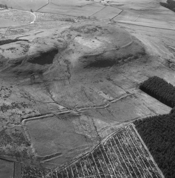
The earthwork complex at Burnswark consists of a Bronze Age cairn, Iron Age hill fort and settlement, Roman camps and a possible fortlet, medieval enclosures, Civil War battery and a triangulation station. The site was first recorded by antiquarians in the 18th century and surveyed by William Roy in the 1750s. The first excavations took place in 1898 and there have been three subsequent interventions, most notably by George Jobey from 1965 to 1970, as well as intensive aerial survey.
The earliest interpretation, in 1785, was that this was the site of a Roman siege. This was generally accepted until 1964 when Kenneth Steer suggested that the camps might have been practice works. The earlier interpretations included other earthworks, or even fugitive features, to propose a circumvallation of the whole hill: the existence or relevance of these elements has been challenged.
The Roman camps have several unusual features, including the different plans of the two camps, the strange layout of the north camp together with its clavicular style entrance, and the three massive traverses along the north side of the south camp, known as the Three Brethren.
Those proposing that Burnswark was used as a training ground by the Roman army cite the walling, paving and debris found in the 1898 excavation in the south camp together with some second century Roman pottery and the interpretation of paving laid at the abandoned west entrance to the hill fort as a target. They also point to the unusual nature of the traverses in front of the north gates of the south camp which also had two phases in its defences. The lead shot found at Burnswark were not generally used by the Roman army in the second century, its use being generally restricted to the time of the Republic. Furthermore, sited atop the relatively gentle slopes of Burnswark hill (particularly on the south side) the hill fort appears to have been abandoned by the time the Roman camps were constructed.
The evidence in favour of a siege includes the assertion that some form of circumvallation did exist (now generally discredited), and that the traverses at the south camp were large and therefore intended to confront a real threat. Jobey was not able to locate the walling recorded in 1898, however, he only sectioned one rampart of the two visible ramparts on the top of Burnswark. There is second century pottery from the hill top and a sling shot was found within a house that was apparently occupied at the time of its deposition.
The Roman activity at Burnswark is best dated to the second century on the basis of the retrieved pottery.
Return to Section 4.1 Landscapes of conquest and resistance
Comments 1
Burnswark: siege or no siege
A talk given by Dr John Reid and Andrew Nicholson 'Burnswark: siege or no siege' at Archaeological Research in Progress 2015 is available here