
The tendency in modern writing is to loosely refer to Scotland‘s regional structure employing labels that Piggott applied in 1962 (and published in 1966), though rarely paying any more than lip-service to the thinking that lay behind them. As he conceived them, the provinces of Tyne-Forth, Clyde-Solway, Atlantic and North-east (1956, 15-16) took their cue from Hawkes‘ scheme for England, which defined five natural provinces within which the structure of the English Iron Age was defined on a ceramic based framework. In recognising that the majority of Scottish Iron Age ceramics could not be used in this way, Piggott‘s four provinces had only the broadest of artefactual definitions and he championed the survey of the settlement record and selective excavation as the route forwards (Piggott 1966). The closer definition of the settlement record was left to Richard Feachem (1966) in the same volume. The modern generation working in the field have little acquaintance with his definitions, nor the culture of thought within which they were conceived. This latter is an important field of research in itself, for the scheme represents the high water mark of post-war culture/historical interpretation, constructed with a compressed chronology and a model for culture change largely limited to one encompassed by the word ‘invasion’. While this is now history, subtle facets of the thinking are still embedded in the way some types of monuments are defined, and it is some of these monuments that lie behind the regional definitions. Furthermore, the dataset upon which many of the regions were defined has expanded dramatically. To take eastern Scotland, for example, the huge numbers and range of structures revealed in the cropmark record was largely unsuspected and the present archaeological community is still trying to shoehorn them into existing categories designed for more limited numbers of upstanding monuments as they were perceived in the post-war years.
While some concept of a regional structure was seen to be useful at that time, the question remains whether the same holds true today, beyond the fact of mere geographical locators. Does a concept of regions based on distributions of types of artefact or site, which may represent differences in time rather than space, help or hinder research? And in any case, how does one expect the geography of culture to be manifested? For it is clear that even as Piggott conceived his provinces they were not impermeable and their edges were rarely tidy divisions between distinct groupings in the landscape. Some modern authors have argued for different definitions of ‘provinces’. For instance, Hingley (1992) separated the Atlantic north and west from the rest of the country, while Harding (2004) used a division of southern, central/eastern, and Atlantic/Argyll in his synthesis of the data, and subsequently suggested a six-fold structure of southern, eastern, central Highlands, north mainland / Northern Isles, Western Isles / Skye / Wester Ross, and Argyll / Inner Hebrides. None of these variants have seen sustained debate or justification. Modern research has tended to focus on ‘site‘, founded on the exploration of individual sites, and only given a wider geography by comparison to similarly explored sites within distributions based on older classifications. Nevertheless, there have been several studies for Doctoral Theses of types of architecture and material culture which have explored regionality (e.g. Pope 2003; Romankiewicz 2011). On the one hand, these studies have confirmed the existence of regional patterns that to some extent sustain Piggott‘s provinces, but, on the other, they have also revealed differences within these regions that blur their boundaries. Many of the variations that have been observed are based on what factors are given priority in the definitions underpinning classification. There is a pressing need for more researchers to explore and redefine the older categories, if only to stimulate the sort of debate that continues to range across brochs/duns and Atlantic round-houses. But there is an equally pressing need to define the limits of visibility and invisibility imposed by the nature of the archaeological record, by patterns of land-use, formation, destruction and recovery (e.g. as encountered in the RCAHMS survey of Eastern Dumfies ). Until this sort of research is begun there is little hope of understanding any distribution of monuments or artefacts, let al.one employing them systematically in any meaningful regional definition.
Underlying these maps is a question of the expectation of site and artefact distributions. Is there some hope that they will reveal socio-political groupings in the archaeological record? To take the much exploited ‘tribal‘ map provided by Ptolemy, it is necessary to be explicit as to intentions and objectives in using this (unrefereed) source to find some manifestation of this in the landscape, either within the archaeology or the later history of kingdoms, lordships, estates and parishes of the quasi-political structures of the Iron Age. Are the largest of the forts at the top of settlement hierarchies, and thus at some stages representing regional centres, which by implication have territories?
Almost the only attempt to carry the logic of the Hawkesian thinking down to the definition of districts within the provinces was carried through in 1962 by Richard Feachem who defined a series of local groups of monuments that bore resemblances to each other (published as Feachem 1966). In Teviotdale, for example, thirty out of the forty forts then known were elongated ridge forts. Such topographically defined categories are unfashionable today, and yet the integrity of the group has never been tested by excavation and nothing is known of their chronology. Other sub-groups are perhaps more convincing, such as the contrast between the stone-walled hut-circles that overlie the forts of Roxburgh and Berwick in the eastern Borders, as against those found within forts in Upper Tweeddale. These sorts of contrast are probably not restricted to the earthwork record of south-east Scotland, but they remain to be observed amongst the cropmarks that are generally subsumed into simple categories of enclosed and unenclosed settlement.
Definition of local ‘types‘ has the potential to play two roles: it defines both elements of local settlement patterns, and entities within the overall settlement pattern. This opens the possibility of identifying mutually interdependent groups of contemporary settlements and reconstructing single units within the settlement pattern made up perhaps of a series of settlements of different status. The physical definition of the landscape which such units occupy is an important field of research, in which there are two possible strands of approach: the first is the definition of areas by combinations of artificial and natural boundaries; the second by exploring the structure of the medieval and modern landscape (see below).
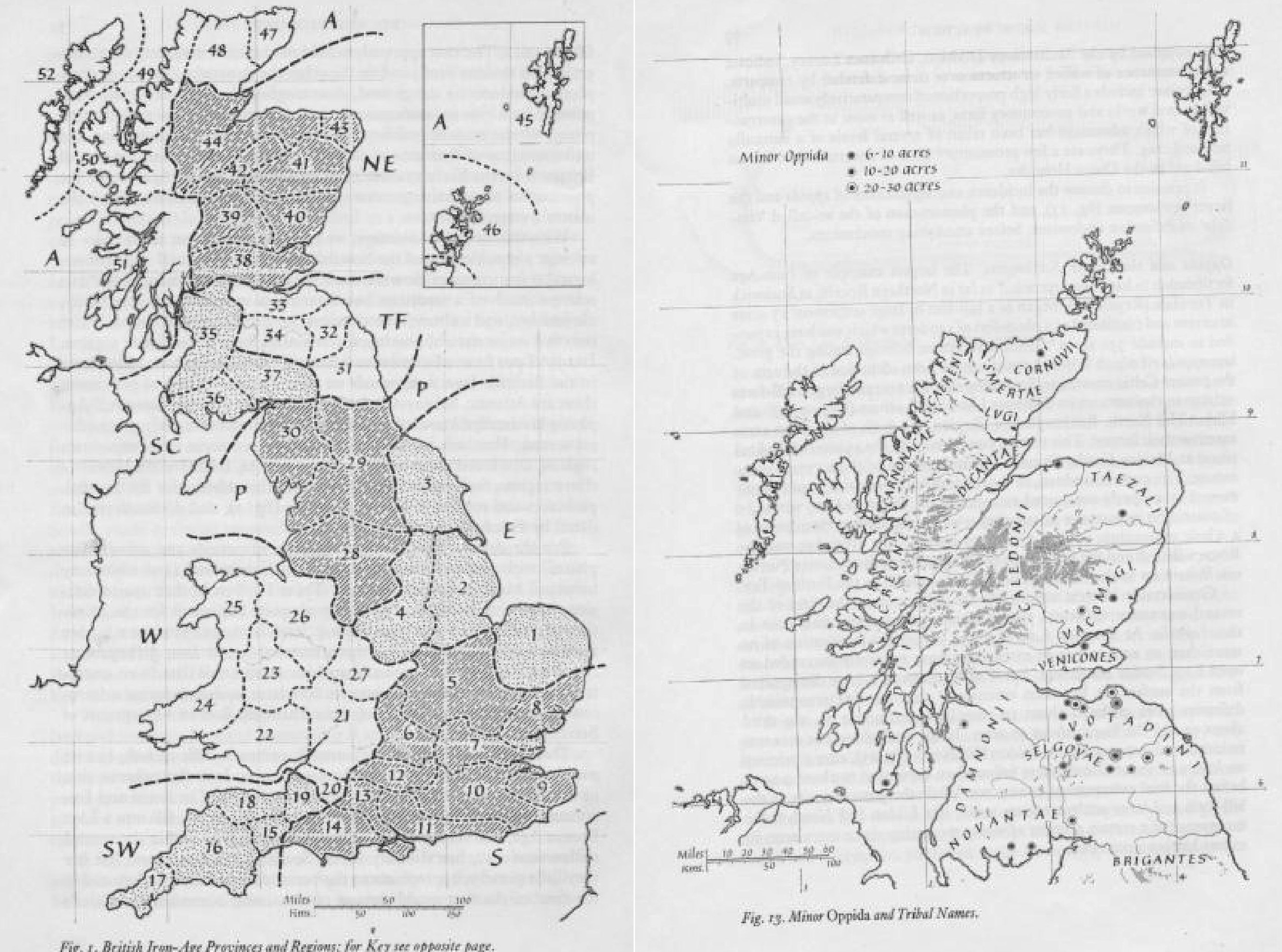
(left) British Iron Age provinces and regions, from Piggott 1966, 4 (right) Minor oppida and tribal names, from Feachem 1966, 79